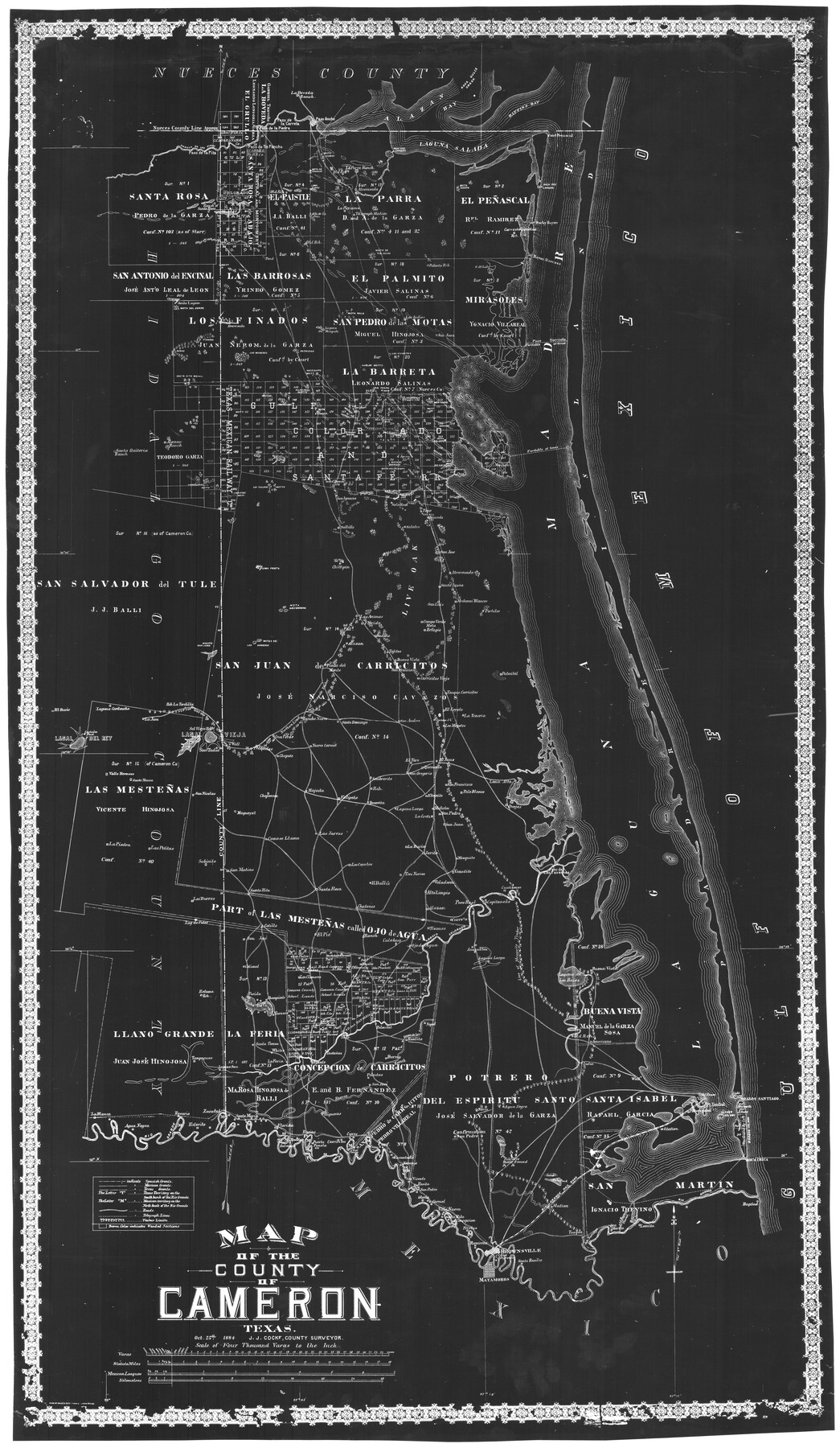
Map of the County of Cameron
-
Map/Doc
78646
-
Collection
General Map Collection
-
Object Dates
10/25/1884 (Creation Date)
-
People and Organizations
Rand, McNally, and Company, Engravers and Printer (Publisher)
Rand McNally and Company (Printer)
J.J. Cocke (Compiler)
J.J. Cocke (Surveyor/Engineer)
-
Counties
Cameron
-
Subjects
County
-
Height x Width
57.0 x 33.2 inches
144.8 x 84.3 cm
-
Comments
Paper print from scan of a mylar negative loaned by George Gause.
-
Features
La Boveda Ranch
Alazan Bay
Agua Dulce Creek
Baffin's Bay
Point Penascal
Laguna Salada
Paso D[]o Landing
La Parra Ranch
Mota Cobos
Mota de Trancas
Paso de la Carreta
Paso de la Piedra
Paso de Tio Pancho
Paso de la Pita
Arroyo de los Olmos
Loma Tunas
La Purisima [Ranch]
Atravesada [Ranch]
Mota Negra
Rock Pen Landing
Rocky Bayou
Bayou Atascosa
Salt Lake
Palmito Ranch
Mota de Tio Culas
Mota del Sierpe
Mota Rala
Los Indios
San Juan [Ranch]
Las Vivoritas [Ranch]
Laguna del Mezquite
Old San Pedro
New San Pedro
Round Mota
Mota del Nido
Mota del Gato
Mota de Oho de Agua
Mota de Borregos
Mota del Campo
Alazan Ranch
Santa Quiteria Ranch
Candelaria Motts
Los Tullidos Motts
Mota Mirion
San Ignacio
Soledad
Topo
Sauceda
Topo Viejo [Ranch]
Atravesada [Ranch]
San Jose [Ranch]
Salates [Ranch]
Saltillo [Ranch]
Chiltipin [Ranch]
Loma Prieta [Ranch]
Mota Devisadera
Las Animas [Ranch]
Florida
Santa Lucia [Ranch]
San Luis [Ranch]
Campo Verde Mota
Refugio
Medanos Blancos [Ranch]
Portales [Ranch]
Badeno [Ranch]
Tajitos [Ranch]
Buena Vista [Ranch]
Alazan [Ranch]
Motas de Los Arrieros
Mogote Don Juan
Punta del Monte
San Francisco
Carricitas Viejo [Ranch]
Palmital [Ranch]
El Coyote [Ranch]
La Teneria [Ranch]
Los Magotes [Ranch]
San Andres [Ranch]
Santo Domingo [Ranch]
Chata [Ranch]
Rancho Nuevo
Cruz Verde
Sal Viega Ranch
Ranch La Tordilla
La Jana [Ranch]
Laguna Cardena
Costales Pond
El Rucio [Ranch]
Valle Hermoso [Ranch]
Santa Monica
San Tadeo [Ranch]
Tresquilas [Ranch]
Chapote [Ranch]
Nuevo Carmel [Ranch]
Sombrerito [Ranch]
El Toro [Ranch]
San Gregorio [Ranch]
El Sauz [Ranch]
Quemada [Ranch]
Loma Alta
Ovejas [Ranch]
Mutatos [Ranch]
San Pedro [Ranch]
San Juan [Ranch]
La Cruz [Ranch]
La Rucia [Ranch]
Laguna Larga
Becerrita [Ranch]
Felipeño [Ranch]
Las Jarras [Ranch]
Como se Llamo [Ranch]
Chapaneca [Ranch]
Magueyal [Ranch]
San Nicolas [Ranch]
La Piedra [Ranch]
Las Petitas [Ranch]
Sabinito [Ranch]
San Matias [Ranch]
Los Coyotes [Ranch]
Tres Norias [Ranch]
Veladeros [Ranch]
Venadito [Ranch]
Jarita [Ranch]
Mezquite [Ranch]
Cuatizones [Ranch]
Paso de Las Tavernas
Capitaneño [Ranch]
Paso Real
Carreta [Ranch]
Arroyo Colorado
Alazon [Ranch]
Tizones [Ranch]
Calaboso [Ranch]
Chatones [Ranch]
Cotillo [Ranch]
El Pie [Ranch]
San Jose [Ranch]
Santa Rita [Ranch]
Los Burros [Ranch]
Lagoon de Palos
Retama Ranch
Colimal [Ranch]
Los Clemores [Ranch]
Laguna Larga
Anacuttas [Ranch]
India
Laguna Madre
Gulf of Mexico
Agua Negra
Noria [Ranch]
Higueras [Ranch]
Santa Maria [Ranch]
Zacatal [Ranch]
Esterito [Ranch]
Rosario [Ranch]
La Blanca [Ranch]
Rucias [Ranch]
Puerta Panola
Venados [Ranch]
Galveston [Ranch]
Carricitos [Ranch]
Barranco [Ranch]
Confirmation San Pedro [Ranch]
Palo Alto Battleground
Vicente [Ranch]
Rosita [Ranch]
San Pedro [Ranch]
Gloria [Ranch]
Carmel [Ranch]
Villa Nueva [Ranch]
Santa Rita [Ranch]
Concepcion [Ranch]
Prietas [Ranch]
Ramireno [Ranch]
Brownsville
Santa Rosalia [Ranch]
Tangue [Ranch]
Part of: General Map Collection
Live Oak County Sketch File 11a

Print $4.00
- Digital $50.00
Live Oak County Sketch File 11a
1876
Size 12.7 x 8.3 inches
Map/Doc 30265
Webb County Sketch File 2-1

Print $6.00
- Digital $50.00
Webb County Sketch File 2-1
1875
Size 9.9 x 8.0 inches
Map/Doc 39710
Pecos County Rolled Sketch 103

Print $20.00
- Digital $50.00
Pecos County Rolled Sketch 103
1940
Size 27.5 x 32.4 inches
Map/Doc 7251

Pecos County Sketch File 38

Print $4.00
- Digital $50.00
Pecos County Sketch File 38
1895
Size 11.3 x 8.8 inches
Map/Doc 33720

Hardin County Working Sketch 6

Print $20.00
- Digital $50.00
Hardin County Working Sketch 6
1922
Size 16.2 x 28.4 inches
Map/Doc 63404
Webb County Working Sketch 6

Print $20.00
- Digital $50.00
Webb County Working Sketch 6
1909
Size 27.8 x 28.3 inches
Map/Doc 72371
Harlem State Farm, East Tract

Print $3.00
- Digital $50.00
Harlem State Farm, East Tract
Size 15.6 x 11.9 inches
Map/Doc 62983
Amistad International Reservoir on Rio Grande 104

Print $20.00
- Digital $50.00
Amistad International Reservoir on Rio Grande 104
1950
Size 28.5 x 40.9 inches
Map/Doc 75535
DeWitt County Sketch File 1

Print $11.00
- Digital $50.00
DeWitt County Sketch File 1
1851
Size 8.4 x 8.2 inches
Map/Doc 20794
Nueces County

Print $20.00
- Digital $50.00
Nueces County
1913
Size 26.9 x 35.9 inches
Map/Doc 95602
You may also like
Rand McNally Standard Map of Texas

Rand McNally Standard Map of Texas
1930
Size 34.6 x 28.0 inches
Map/Doc 2147
Presidio County Working Sketch 9

Print $20.00
- Digital $50.00
Presidio County Working Sketch 9
1928
Size 40.7 x 18.5 inches
Map/Doc 71683
Marion County Working Sketch 37

Print $20.00
- Digital $50.00
Marion County Working Sketch 37
1986
Size 30.0 x 43.0 inches
Map/Doc 70813
Goliad County Working Sketch 3

Print $40.00
- Digital $50.00
Goliad County Working Sketch 3
1916
Size 42.8 x 76.4 inches
Map/Doc 63193
Hidalgo County Sketch File 9

Print $40.00
- Digital $50.00
Hidalgo County Sketch File 9
1904
Size 8.8 x 5.7 inches
Map/Doc 26409
Cameron County State Real Property Sketch 2

Print $20.00
- Digital $50.00
Cameron County State Real Property Sketch 2
1996
Size 25.4 x 39.1 inches
Map/Doc 80132
El Paso County Working Sketch 22

Print $20.00
- Digital $50.00
El Paso County Working Sketch 22
1961
Size 21.6 x 20.0 inches
Map/Doc 69044
Hardin County Sketch File 19

Print $6.00
- Digital $50.00
Hardin County Sketch File 19
Size 13.0 x 10.9 inches
Map/Doc 25135
Galveston County NRC Article 33.136 Sketch 99

Print $26.00
Galveston County NRC Article 33.136 Sketch 99
2024
Map/Doc 97422
Dallas County Rolled Sketch 4A
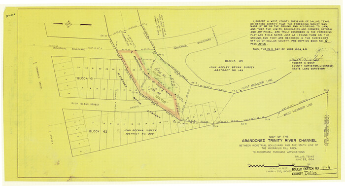
Print $20.00
- Digital $50.00
Dallas County Rolled Sketch 4A
1954
Size 12.5 x 23.1 inches
Map/Doc 5688
[Surveys in Austin's Colony along the San Antonio Road and the Navasota River]
![202, [Surveys in Austin's Colony along the San Antonio Road and the Navasota River], General Map Collection](https://historictexasmaps.com/wmedia_w700/maps/202.tif.jpg)
Print $20.00
- Digital $50.00
[Surveys in Austin's Colony along the San Antonio Road and the Navasota River]
1833
Size 16.1 x 34.7 inches
Map/Doc 202
General Highway Map, Milam County, Texas

Print $20.00
General Highway Map, Milam County, Texas
1961
Size 18.1 x 24.6 inches
Map/Doc 79597