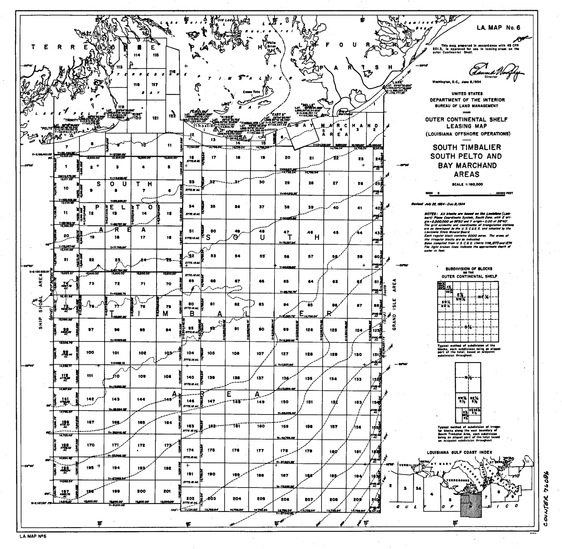
Outer Continental Shelf Leasing Maps (Louisiana Offshore Operations)
D-7-3; D-7-4
-
Map/Doc
76086
-
Collection
General Map Collection
-
Object Dates
1955/8/5 (Creation Date)
-
Subjects
Energy Offshore Submerged Area
-
Height x Width
12.4 x 12.7 inches
31.5 x 32.3 cm
Part of: General Map Collection
Flight Mission No. CGI-4N, Frame 20, Cameron County

Print $20.00
- Digital $50.00
Flight Mission No. CGI-4N, Frame 20, Cameron County
1954
Size 18.6 x 22.3 inches
Map/Doc 84653
Leon County Working Sketch 13

Print $20.00
- Digital $50.00
Leon County Working Sketch 13
1956
Size 23.0 x 22.7 inches
Map/Doc 70412
Map of Part of Texas Prison System, Blue Ridge State Farm, Fort Bend and Harris Counties

Print $20.00
- Digital $50.00
Map of Part of Texas Prison System, Blue Ridge State Farm, Fort Bend and Harris Counties
Size 24.1 x 26.3 inches
Map/Doc 62981
Webb County Sketch File 71

Print $44.00
- Digital $50.00
Webb County Sketch File 71
Size 14.4 x 7.6 inches
Map/Doc 39888
Jack County Sketch File 11

Print $4.00
- Digital $50.00
Jack County Sketch File 11
1858
Size 10.2 x 8.1 inches
Map/Doc 27531
Martin County Working Sketch Graphic Index

Print $20.00
- Digital $50.00
Martin County Working Sketch Graphic Index
1933
Size 44.1 x 37.8 inches
Map/Doc 76631
Hemphill County Working Sketch 19

Print $20.00
- Digital $50.00
Hemphill County Working Sketch 19
1972
Size 35.8 x 42.6 inches
Map/Doc 66114
Glasscock County Rolled Sketch 8

Print $20.00
- Digital $50.00
Glasscock County Rolled Sketch 8
1951
Size 37.3 x 31.1 inches
Map/Doc 9057
Midland County Rolled Sketch 1

Print $20.00
- Digital $50.00
Midland County Rolled Sketch 1
1940
Size 32.9 x 35.0 inches
Map/Doc 9512
Rockport Quadrangle

Print $20.00
- Digital $50.00
Rockport Quadrangle
1954
Size 21.3 x 18.3 inches
Map/Doc 73435
Bee County Working Sketch 31a

Print $20.00
- Digital $50.00
Bee County Working Sketch 31a
1988
Size 39.5 x 43.2 inches
Map/Doc 76052
Flight Mission No. DQN-1K, Frame 122, Calhoun County

Print $20.00
- Digital $50.00
Flight Mission No. DQN-1K, Frame 122, Calhoun County
1953
Size 18.5 x 22.2 inches
Map/Doc 84188
You may also like
Val Verde County Working Sketch 108

Print $20.00
- Digital $50.00
Val Verde County Working Sketch 108
1988
Size 31.1 x 41.3 inches
Map/Doc 72243
Flight Mission No. BQY-4M, Frame 114, Harris County

Print $20.00
- Digital $50.00
Flight Mission No. BQY-4M, Frame 114, Harris County
1953
Size 18.7 x 22.5 inches
Map/Doc 85281
Map of Bexar County

Print $40.00
- Digital $50.00
Map of Bexar County
1887
Size 46.1 x 48.6 inches
Map/Doc 16942
Index to Titles, Field Notes, and Plats in the Spanish Archives

Index to Titles, Field Notes, and Plats in the Spanish Archives
1942
Size 17.5 x 10.1 inches
Map/Doc 94524
Map exhibiting the lines of march passed over by the troops of the United States during the year ending June 30th, 1858 prepared by order of the Hon. J.B. Floyd, Sec. War.

Print $20.00
- Digital $50.00
Map exhibiting the lines of march passed over by the troops of the United States during the year ending June 30th, 1858 prepared by order of the Hon. J.B. Floyd, Sec. War.
1858
Size 20.0 x 20.3 inches
Map/Doc 94079
Mills County Boundary File 2

Print $6.00
- Digital $50.00
Mills County Boundary File 2
Size 14.1 x 8.7 inches
Map/Doc 57278
Upton County Boundary File 2

Print $6.00
- Digital $50.00
Upton County Boundary File 2
Size 14.4 x 8.9 inches
Map/Doc 59517
Travis County Sketch File 11a

Print $4.00
- Digital $50.00
Travis County Sketch File 11a
1873
Size 10.0 x 8.0 inches
Map/Doc 38302
Hays County Sketch File 2

Print $4.00
- Digital $50.00
Hays County Sketch File 2
1846
Size 6.3 x 8.1 inches
Map/Doc 26200
Shelby County Working Sketch 1

Print $20.00
- Digital $50.00
Shelby County Working Sketch 1
1917
Size 26.2 x 30.0 inches
Map/Doc 63854
Map of Clay County, Texas

Print $20.00
- Digital $50.00
Map of Clay County, Texas
1880
Size 33.0 x 23.2 inches
Map/Doc 699
Wheeler County Working Sketch 14

Print $20.00
- Digital $50.00
Wheeler County Working Sketch 14
1979
Size 20.1 x 37.2 inches
Map/Doc 72503