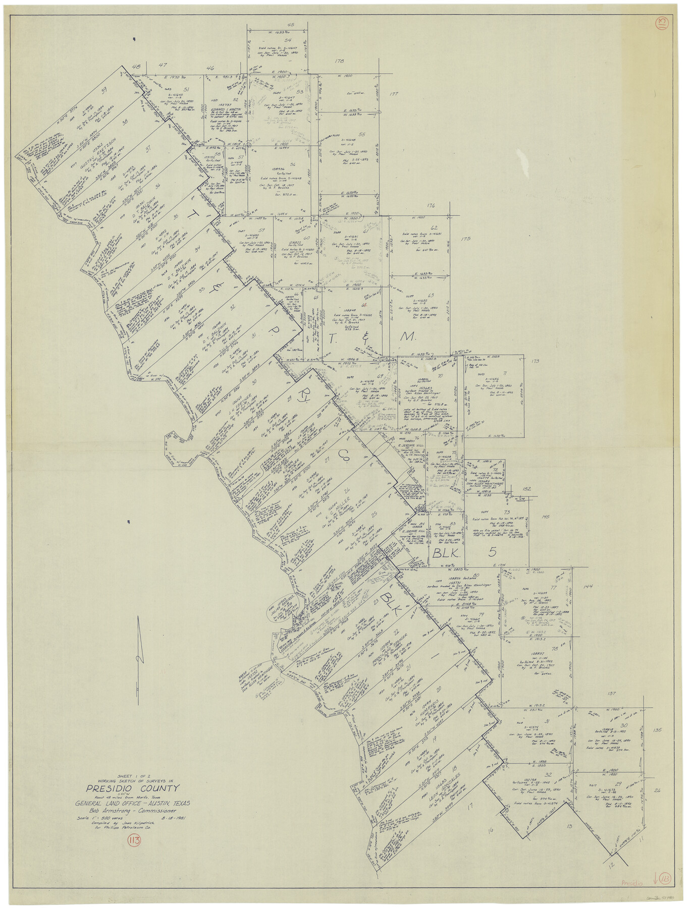
Presidio County Working Sketch 113
-
Map/Doc
71790
-
Collection
General Map Collection
-
Object Dates
8/18/1981 (Creation Date)
-
People and Organizations
Joan Kilpatrick (Compiler)
-
Counties
Presidio
-
Subjects
Surveying Working Sketch
-
Height x Width
48.9 x 37.1 inches
124.2 x 94.2 cm
-
Scale
1" = 500 varas
Part of: General Map Collection
Falls County Sketch File 27

Print $6.00
- Digital $50.00
Falls County Sketch File 27
Size 16.1 x 11.0 inches
Map/Doc 22436
Crane County Working Sketch 25

Print $20.00
- Digital $50.00
Crane County Working Sketch 25
1969
Size 33.0 x 26.3 inches
Map/Doc 68302
Cameron County Rolled Sketch 28

Print $40.00
- Digital $50.00
Cameron County Rolled Sketch 28
1986
Size 36.5 x 48.3 inches
Map/Doc 8575
Atascosa County Working Sketch 11

Print $20.00
- Digital $50.00
Atascosa County Working Sketch 11
1923
Size 13.9 x 17.1 inches
Map/Doc 67207
Tom Green County Working Sketch 11

Print $20.00
- Digital $50.00
Tom Green County Working Sketch 11
1968
Size 33.9 x 39.2 inches
Map/Doc 69380
Garza County Boundary File 2a

Print $8.00
- Digital $50.00
Garza County Boundary File 2a
Size 14.4 x 8.9 inches
Map/Doc 53675
Harris County Working Sketch 68

Print $20.00
- Digital $50.00
Harris County Working Sketch 68
1955
Size 29.3 x 24.3 inches
Map/Doc 65960
Hudspeth County Rolled Sketch 75

Print $40.00
- Digital $50.00
Hudspeth County Rolled Sketch 75
1992
Size 35.6 x 48.9 inches
Map/Doc 9238
United States - Gulf Coast Texas - Southern part of Laguna Madre

Print $20.00
- Digital $50.00
United States - Gulf Coast Texas - Southern part of Laguna Madre
1941
Size 27.1 x 18.3 inches
Map/Doc 72954
Medina County Sketch File 13

Print $20.00
- Digital $50.00
Medina County Sketch File 13
Size 18.1 x 22.7 inches
Map/Doc 12069
Medina County Working Sketch Graphic Index

Print $40.00
- Digital $50.00
Medina County Working Sketch Graphic Index
1976
Size 52.8 x 42.8 inches
Map/Doc 76639
[Caddo Lake & Subdivisions]
![2896, [Caddo Lake & Subdivisions], General Map Collection](https://historictexasmaps.com/wmedia_w700/maps/2896-1.tif.jpg)
Print $20.00
- Digital $50.00
[Caddo Lake & Subdivisions]
1918
Size 31.3 x 28.6 inches
Map/Doc 2896
You may also like
Map of Spearman Lands

Print $20.00
- Digital $50.00
Map of Spearman Lands
Size 20.4 x 15.6 inches
Map/Doc 90834
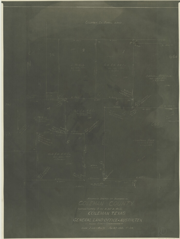
Coleman County Working Sketch 11
Print $20.00
- Digital $50.00
Coleman County Working Sketch 11
1950
Size 24.2 x 18.2 inches
Map/Doc 68077
Menard County Rolled Sketch 2

Print $20.00
- Digital $50.00
Menard County Rolled Sketch 2
1883
Size 25.0 x 19.9 inches
Map/Doc 6752
Bell County Working Sketch 20

Print $20.00
- Digital $50.00
Bell County Working Sketch 20
1996
Size 39.5 x 34.7 inches
Map/Doc 67360
A Plat of 23 Miles of the Colorado River
![65651, [Sketch for Mineral Application 1742], General Map Collection](https://historictexasmaps.com/wmedia_w700/maps/65651.tif.jpg)
Print $40.00
- Digital $50.00
A Plat of 23 Miles of the Colorado River
1918
Size 38.3 x 56.7 inches
Map/Doc 65651
Map of Shelby County

Print $20.00
- Digital $50.00
Map of Shelby County
1863
Size 18.6 x 22.3 inches
Map/Doc 4031
Big Lake Oil Field

Print $20.00
- Digital $50.00
Big Lake Oil Field
1924
Size 27.3 x 19.1 inches
Map/Doc 2420
Bell County Sketch File 25

Print $8.00
- Digital $50.00
Bell County Sketch File 25
Size 5.1 x 5.3 inches
Map/Doc 14420
Jefferson County Rolled Sketch 58

Print $40.00
- Digital $50.00
Jefferson County Rolled Sketch 58
1897
Size 21.4 x 60.3 inches
Map/Doc 9312
Parker County Sketch File 40

Print $4.00
- Digital $50.00
Parker County Sketch File 40
Size 8.1 x 12.7 inches
Map/Doc 33585
Flight Mission No. BRA-6M, Frame 94, Jefferson County

Print $20.00
- Digital $50.00
Flight Mission No. BRA-6M, Frame 94, Jefferson County
1953
Size 18.6 x 22.4 inches
Map/Doc 85437
Mapa original de Texas por el Ciudadano Estevan F. Austin Presentado al Excmo. Sr. Presidente, por su Autor

Mapa original de Texas por el Ciudadano Estevan F. Austin Presentado al Excmo. Sr. Presidente, por su Autor
1830
Size 31.6 x 25.4 inches
Map/Doc 94562