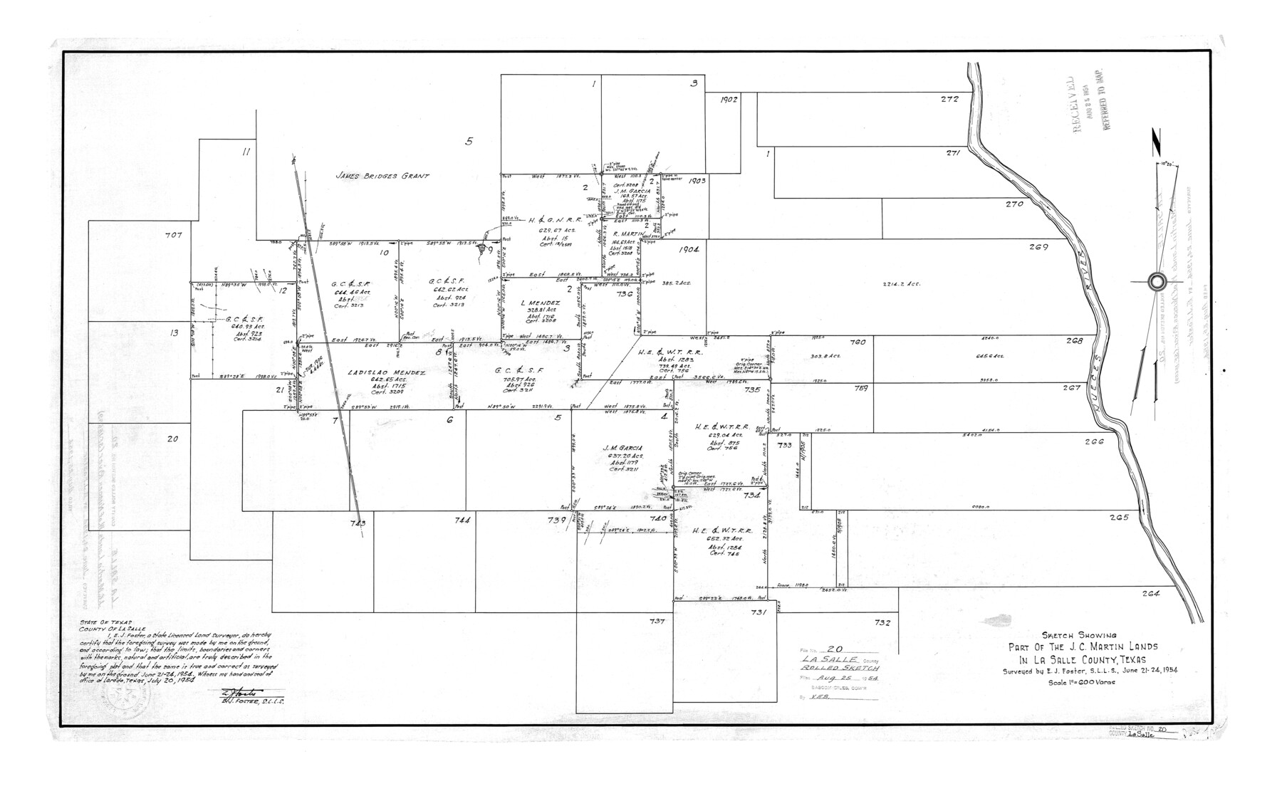
La Salle County Rolled Sketch 20
Sketch showing part of the J.C. Martin lands in La Salle County, Texas
-
Map/Doc
6584
-
Collection
General Map Collection
-
Object Dates
1954/6/24 (Survey Date)
1954/8/25 (File Date)
1954/7/20 (Creation Date)
-
People and Organizations
E.J. Foster (Surveyor/Engineer)
-
Counties
La Salle
-
Subjects
Surveying Rolled Sketch
-
Height x Width
24.6 x 40.1 inches
62.5 x 101.9 cm
-
Scale
1" = 600 varas
-
Comments
See SF-15659.
Part of: General Map Collection
Martin County

Print $20.00
- Digital $50.00
Martin County
1933
Size 38.9 x 34.0 inches
Map/Doc 77366
Houston County Working Sketch 37

Print $20.00
- Digital $50.00
Houston County Working Sketch 37
2006
Size 33.0 x 40.0 inches
Map/Doc 83627
Yoakum County

Print $20.00
- Digital $50.00
Yoakum County
1902
Size 46.1 x 36.6 inches
Map/Doc 63138
Pecos County Sketch File 28a

Print $14.00
- Digital $50.00
Pecos County Sketch File 28a
1911
Size 14.5 x 8.9 inches
Map/Doc 33683
McLennan County Sketch File 5

Print $9.00
- Digital $50.00
McLennan County Sketch File 5
Size 11.0 x 17.0 inches
Map/Doc 31240
Edwards County Sketch File 10b

Print $20.00
- Digital $50.00
Edwards County Sketch File 10b
1903
Size 17.0 x 18.9 inches
Map/Doc 11423
Reeves County Working Sketch 23

Print $40.00
- Digital $50.00
Reeves County Working Sketch 23
1966
Size 31.6 x 54.5 inches
Map/Doc 63466
Map showing the environs of Brazos Island, Texas

Print $20.00
- Digital $50.00
Map showing the environs of Brazos Island, Texas
Size 18.2 x 25.0 inches
Map/Doc 72925

Hansford County Boundary File 2b

Print $14.00
- Digital $50.00
Hansford County Boundary File 2b
Size 14.3 x 8.8 inches
Map/Doc 54263
Flight Mission No. DCL-6C, Frame 19, Kenedy County

Print $20.00
- Digital $50.00
Flight Mission No. DCL-6C, Frame 19, Kenedy County
1943
Size 18.6 x 22.4 inches
Map/Doc 85876
Ward County Working Sketch 51

Print $40.00
- Digital $50.00
Ward County Working Sketch 51
1980
Size 34.4 x 52.1 inches
Map/Doc 72357
You may also like
Leon County Working Sketch 1

Print $20.00
- Digital $50.00
Leon County Working Sketch 1
Size 16.1 x 18.7 inches
Map/Doc 70400
Pecos County Rolled Sketch 155

Print $40.00
- Digital $50.00
Pecos County Rolled Sketch 155
Size 65.1 x 44.8 inches
Map/Doc 9737
Presidio County Rolled Sketch T-5

Print $20.00
- Digital $50.00
Presidio County Rolled Sketch T-5
1917
Size 21.2 x 20.4 inches
Map/Doc 7419
[De Loches County School Land]
![91198, [De Loches County School Land], Twichell Survey Records](https://historictexasmaps.com/wmedia_w700/maps/91198-1.tif.jpg)
Print $20.00
- Digital $50.00
[De Loches County School Land]
Size 20.4 x 35.2 inches
Map/Doc 91198
Land grants from the state of Tamaulipas in the trans-Nueces

Land grants from the state of Tamaulipas in the trans-Nueces
2009
Size 11.0 x 8.5 inches
Map/Doc 94040
[Surveys along the Liberty and Hardin County line]
![295, [Surveys along the Liberty and Hardin County line], General Map Collection](https://historictexasmaps.com/wmedia_w700/maps/295.tif.jpg)
Print $2.00
- Digital $50.00
[Surveys along the Liberty and Hardin County line]
1847
Size 13.5 x 7.7 inches
Map/Doc 295
[Sketch of part of G. & M. Block 5]
![93073, [Sketch of part of G. & M. Block 5], Twichell Survey Records](https://historictexasmaps.com/wmedia_w700/maps/93073-1.tif.jpg)
Print $2.00
- Digital $50.00
[Sketch of part of G. & M. Block 5]
Size 6.7 x 8.7 inches
Map/Doc 93073

Controlled Mosaic by Jack Amman Photogrammetric Engineers, Inc - Sheet 50

Print $20.00
- Digital $50.00
Controlled Mosaic by Jack Amman Photogrammetric Engineers, Inc - Sheet 50
1954
Size 20.0 x 24.0 inches
Map/Doc 83509
The Peters Colony. July 26, 1842

Print $20.00
The Peters Colony. July 26, 1842
2020
Size 21.7 x 21.7 inches
Map/Doc 96364
[Travis District]
![88740, [Travis District], General Map Collection](https://historictexasmaps.com/wmedia_w700/maps/88740.tif.jpg)
Print $40.00
- Digital $50.00
[Travis District]
1840
Size 54.7 x 46.0 inches
Map/Doc 88740
Concho County Rolled Sketch 18

Print $20.00
- Digital $50.00
Concho County Rolled Sketch 18
1955
Size 11.4 x 18.3 inches
Map/Doc 5553