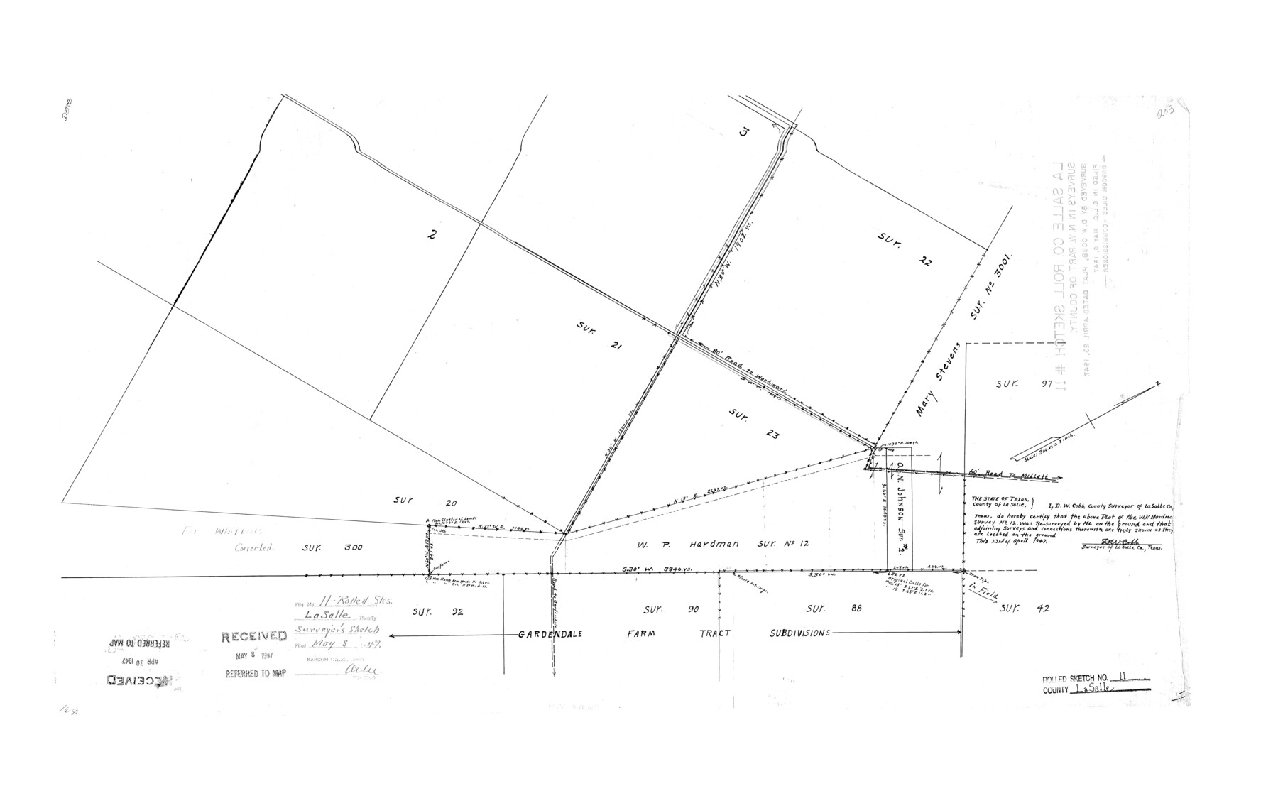
La Salle County Rolled Sketch 11
[Plat of W.P. Hardman survey no. 12 and surrounding area]
-
Map/Doc
6574
-
Collection
General Map Collection
-
Object Dates
1947/4/23 (Creation Date)
1947/5/8 (File Date)
-
People and Organizations
D.W. Cobb (Surveyor/Engineer)
-
Counties
La Salle
-
Subjects
Surveying Rolled Sketch
-
Height x Width
22.1 x 35.8 inches
56.1 x 90.9 cm
-
Scale
1" = 300 varas
Part of: General Map Collection
Flight Mission No. DQO-8K, Frame 14, Galveston County

Print $20.00
- Digital $50.00
Flight Mission No. DQO-8K, Frame 14, Galveston County
1952
Size 18.7 x 22.4 inches
Map/Doc 85137
Kimble County Working Sketch 29

Print $20.00
- Digital $50.00
Kimble County Working Sketch 29
1941
Size 24.7 x 15.3 inches
Map/Doc 70097
Flight Mission No. DQO-1K, Frame 113, Galveston County

Print $20.00
- Digital $50.00
Flight Mission No. DQO-1K, Frame 113, Galveston County
1952
Size 18.9 x 22.7 inches
Map/Doc 84991
Flight Mission No. DQO-7K, Frame 110, Galveston County

Print $20.00
- Digital $50.00
Flight Mission No. DQO-7K, Frame 110, Galveston County
1952
Size 18.7 x 22.3 inches
Map/Doc 85125
Schleicher County Sketch File 37

Print $20.00
- Digital $50.00
Schleicher County Sketch File 37
1952
Size 24.9 x 29.3 inches
Map/Doc 12310
Cameron County Rolled Sketch 7

Print $20.00
- Digital $50.00
Cameron County Rolled Sketch 7
1926
Size 27.4 x 31.8 inches
Map/Doc 8563
Kenedy County Aerial Photograph Index Sheet 2

Print $20.00
- Digital $50.00
Kenedy County Aerial Photograph Index Sheet 2
1943
Size 23.1 x 19.3 inches
Map/Doc 83714
Mitchell County Sketch File 16a

Print $12.00
- Digital $50.00
Mitchell County Sketch File 16a
1933
Size 11.3 x 8.8 inches
Map/Doc 31703
Crockett County Sketch File H

Print $26.00
- Digital $50.00
Crockett County Sketch File H
1920
Size 14.4 x 9.0 inches
Map/Doc 19638
Edwards County Sketch File 37

Print $4.00
- Digital $50.00
Edwards County Sketch File 37
1926
Size 11.3 x 9.0 inches
Map/Doc 21771
Bee County Sketch File 32

Print $4.00
- Digital $50.00
Bee County Sketch File 32
Size 7.9 x 12.6 inches
Map/Doc 14347
Flight Mission No. DQN-1K, Frame 78, Calhoun County

Print $20.00
- Digital $50.00
Flight Mission No. DQN-1K, Frame 78, Calhoun County
1953
Size 18.5 x 22.1 inches
Map/Doc 84163
You may also like
Bee County Boundary File 5

Print $12.00
- Digital $50.00
Bee County Boundary File 5
Size 9.1 x 9.0 inches
Map/Doc 50452
Edwards County Working Sketch 115

Print $20.00
- Digital $50.00
Edwards County Working Sketch 115
1973
Size 39.6 x 43.9 inches
Map/Doc 68991
[Surveys along the Red River and Capitol Lands]
![90738, [Surveys along the Red River and Capitol Lands], Twichell Survey Records](https://historictexasmaps.com/wmedia_w700/maps/90738-1.tif.jpg)
Print $20.00
- Digital $50.00
[Surveys along the Red River and Capitol Lands]
Size 24.8 x 39.7 inches
Map/Doc 90738
Knox County Working Sketch 6

Print $20.00
- Digital $50.00
Knox County Working Sketch 6
1937
Size 31.4 x 18.2 inches
Map/Doc 70248
Karnes County Sketch File 12

Print $14.00
- Digital $50.00
Karnes County Sketch File 12
1889
Size 12.7 x 8.0 inches
Map/Doc 28604
Hydrography of Sabine Pass and Lake, La. And Tex.

Print $40.00
- Digital $50.00
Hydrography of Sabine Pass and Lake, La. And Tex.
1885
Size 53.2 x 32.5 inches
Map/Doc 2085
Archer County Sketch File 26

Print $4.00
- Digital $50.00
Archer County Sketch File 26
1934
Size 9.7 x 4.4 inches
Map/Doc 13663
Real County Working Sketch Graphic Index, Sheet 2 (Sketches 43 to Most Recent)

Print $20.00
- Digital $50.00
Real County Working Sketch Graphic Index, Sheet 2 (Sketches 43 to Most Recent)
1972
Size 43.2 x 31.1 inches
Map/Doc 76679
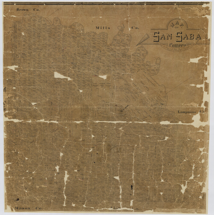
Map of San Saba County
Print $20.00
- Digital $50.00
Map of San Saba County
1887
Size 41.1 x 40.9 inches
Map/Doc 16809
Real County Working Sketch 12

Print $20.00
- Digital $50.00
Real County Working Sketch 12
1931
Size 19.1 x 18.6 inches
Map/Doc 71904
Val Verde County Working Sketch 62

Print $40.00
- Digital $50.00
Val Verde County Working Sketch 62
1959
Size 38.3 x 56.6 inches
Map/Doc 72197
Karte von Indian Point od Indianola / Karte der Stadt Neu Braunfels / Karte der Stadt Friedrichsburg / Hafen von Indian Point oder Indianola (Carlshafen) [Four map insets]
![79297, Karte von Indian Point od Indianola / Karte der Stadt Neu Braunfels / Karte der Stadt Friedrichsburg / Hafen von Indian Point oder Indianola (Carlshafen) [Four map insets], Texas State Library and Archives](https://historictexasmaps.com/wmedia_w700/maps/79297.tif.jpg)
Print $20.00
Karte von Indian Point od Indianola / Karte der Stadt Neu Braunfels / Karte der Stadt Friedrichsburg / Hafen von Indian Point oder Indianola (Carlshafen) [Four map insets]
1850
Size 13.3 x 19.4 inches
Map/Doc 79297