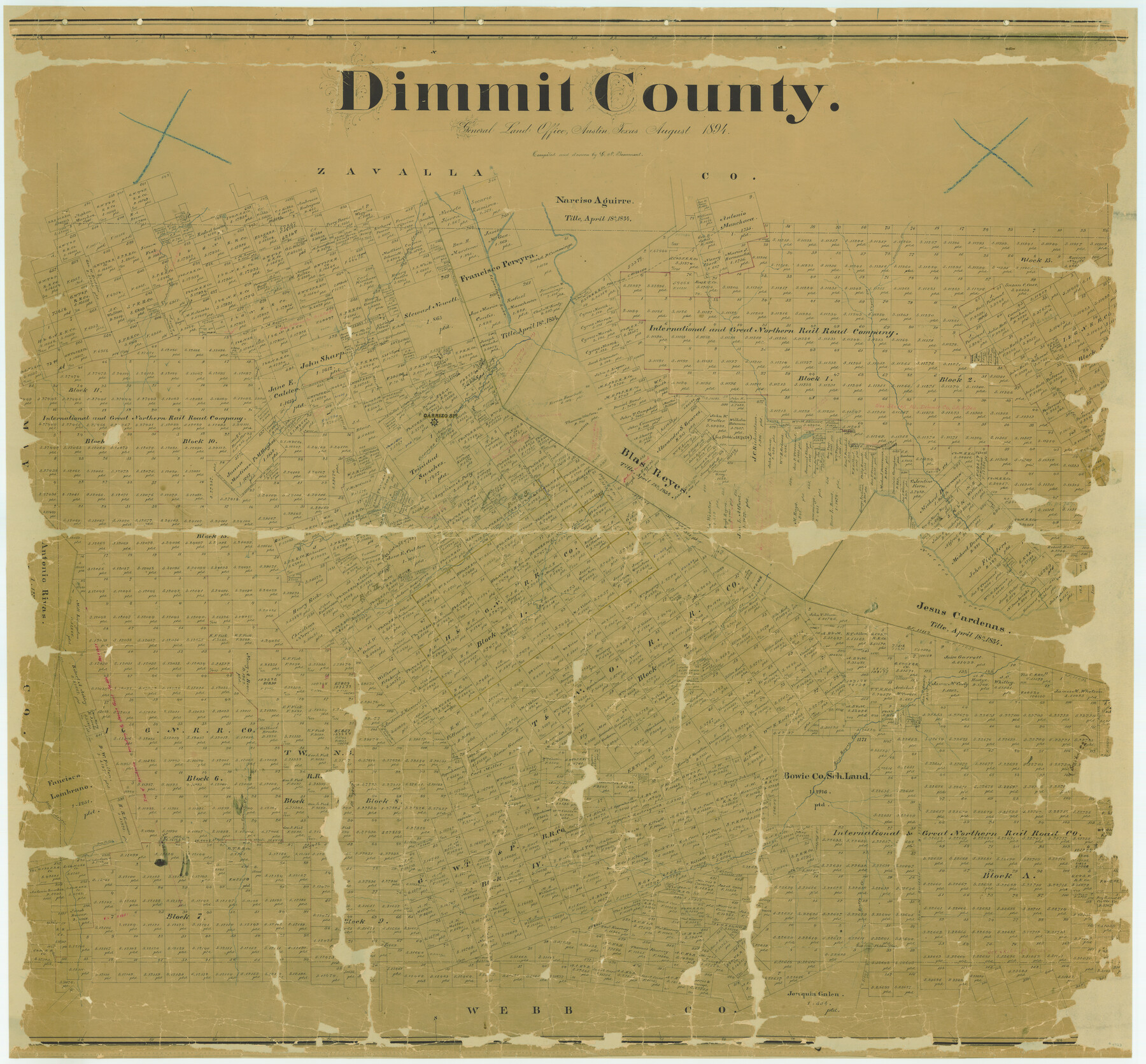
Dimmit County
-
Map/Doc
4723
-
Collection
General Map Collection
-
Object Dates
1894 (Creation Date)
-
People and Organizations
Texas General Land Office (Publisher)
G.N. Beaumont (Draftsman)
G.N. Beaumont (Compiler)
-
Counties
Dimmit
-
Subjects
County
-
Height x Width
41.7 x 44.9 inches
105.9 x 114.0 cm
-
Comments
Conservation funded in 2004 with donation from Union State Bank.
-
Features
Carrizo Creek
Los Piloncillos
Burro Creek
San Lorenzo Creek
San Pedro Creek
San Ambrosio Creek
San Rogue Creek
Apuracion Creek
Barroso Creek
El Moro Creek
Nueces River
West Fork of Carrizo Creek
Carrizo Springs
Anderson Creek
Negro Creek
Tortugas Creek
Presidio Crossing
Espio Creek
Espantoso Lake
Pena Creek
Pendencia Creek
Part of: General Map Collection
Uvalde County Working Sketch 61

Print $20.00
- Digital $50.00
Uvalde County Working Sketch 61
1978
Size 40.4 x 37.4 inches
Map/Doc 72131
Harris County Working Sketch 71

Print $20.00
- Digital $50.00
Harris County Working Sketch 71
1957
Size 26.8 x 42.3 inches
Map/Doc 65963
Starr County Sketch File 7

Print $20.00
- Digital $50.00
Starr County Sketch File 7
Size 25.4 x 20.8 inches
Map/Doc 12326
Intracoastal Waterway, Houma, LA to Corpus Christi, TX

Print $5.00
- Digital $50.00
Intracoastal Waterway, Houma, LA to Corpus Christi, TX
Size 22.0 x 30.0 inches
Map/Doc 61912
Gaines County Rolled Sketch 20

Print $20.00
- Digital $50.00
Gaines County Rolled Sketch 20
1955
Size 30.1 x 37.2 inches
Map/Doc 5936
San Saba County Sketch File 16

Print $20.00
- Digital $50.00
San Saba County Sketch File 16
1902
Size 16.9 x 18.8 inches
Map/Doc 12294
Flight Mission No. DQN-2K, Frame 138, Calhoun County

Print $20.00
- Digital $50.00
Flight Mission No. DQN-2K, Frame 138, Calhoun County
1953
Size 16.1 x 16.0 inches
Map/Doc 84307
Wheeler County Working Sketch 11

Print $40.00
- Digital $50.00
Wheeler County Working Sketch 11
1973
Size 77.4 x 44.0 inches
Map/Doc 72500

Reagan County Working Sketch 20

Print $40.00
- Digital $50.00
Reagan County Working Sketch 20
1954
Size 37.5 x 68.2 inches
Map/Doc 71862
Bexar County Sketch File 36c

Print $20.00
- Digital $50.00
Bexar County Sketch File 36c
1874
Size 19.3 x 26.4 inches
Map/Doc 10922
Montgomery County Working Sketch Graphic Index, Sheet 2 (Sketches 36 to Most Recent)

Print $40.00
- Digital $50.00
Montgomery County Working Sketch Graphic Index, Sheet 2 (Sketches 36 to Most Recent)
1943
Size 42.9 x 51.9 inches
Map/Doc 76647
You may also like
Mitchell County Working Sketch 1

Print $20.00
- Digital $50.00
Mitchell County Working Sketch 1
1905
Size 24.2 x 20.7 inches
Map/Doc 71058
Railroad Track Map, H&TCRRCo., Falls County, Texas

Print $4.00
- Digital $50.00
Railroad Track Map, H&TCRRCo., Falls County, Texas
1918
Size 11.7 x 18.5 inches
Map/Doc 62833
Blanco County Sketch File 31a

Print $4.00
- Digital $50.00
Blanco County Sketch File 31a
1889
Size 8.6 x 14.1 inches
Map/Doc 14631
Williamson County Working Sketch 7

Print $20.00
- Digital $50.00
Williamson County Working Sketch 7
1949
Size 30.2 x 37.3 inches
Map/Doc 72567
Archer County Working Sketch 12

Print $20.00
- Digital $50.00
Archer County Working Sketch 12
1939
Size 11.2 x 18.7 inches
Map/Doc 67153
[Z. C. Collier survey owned by Pease Estate, Hutchinson County]
![4472, [Z. C. Collier survey owned by Pease Estate, Hutchinson County], Maddox Collection](https://historictexasmaps.com/wmedia_w700/maps/4472-1.tif.jpg)
Print $20.00
- Digital $50.00
[Z. C. Collier survey owned by Pease Estate, Hutchinson County]
Size 19.0 x 20.8 inches
Map/Doc 4472
Glasscock County Sketch File 12

Print $5.00
- Digital $50.00
Glasscock County Sketch File 12
1935
Size 14.1 x 9.2 inches
Map/Doc 24176
Williamson County Sketch File 11

Print $4.00
- Digital $50.00
Williamson County Sketch File 11
Size 8.2 x 9.2 inches
Map/Doc 40324
Brewster County Working Sketch 9

Print $20.00
- Digital $50.00
Brewster County Working Sketch 9
1910
Size 14.3 x 14.4 inches
Map/Doc 67542
Palo Pinto County Working Sketch 20

Print $20.00
- Digital $50.00
Palo Pinto County Working Sketch 20
1977
Size 30.2 x 38.1 inches
Map/Doc 71403
Flight Mission No. BRA-16M, Frame 182, Jefferson County

Print $20.00
- Digital $50.00
Flight Mission No. BRA-16M, Frame 182, Jefferson County
1953
Size 18.6 x 22.4 inches
Map/Doc 85780
Cherokee County Sketch File 31

Print $6.00
- Digital $50.00
Cherokee County Sketch File 31
1934
Size 14.0 x 8.9 inches
Map/Doc 18184