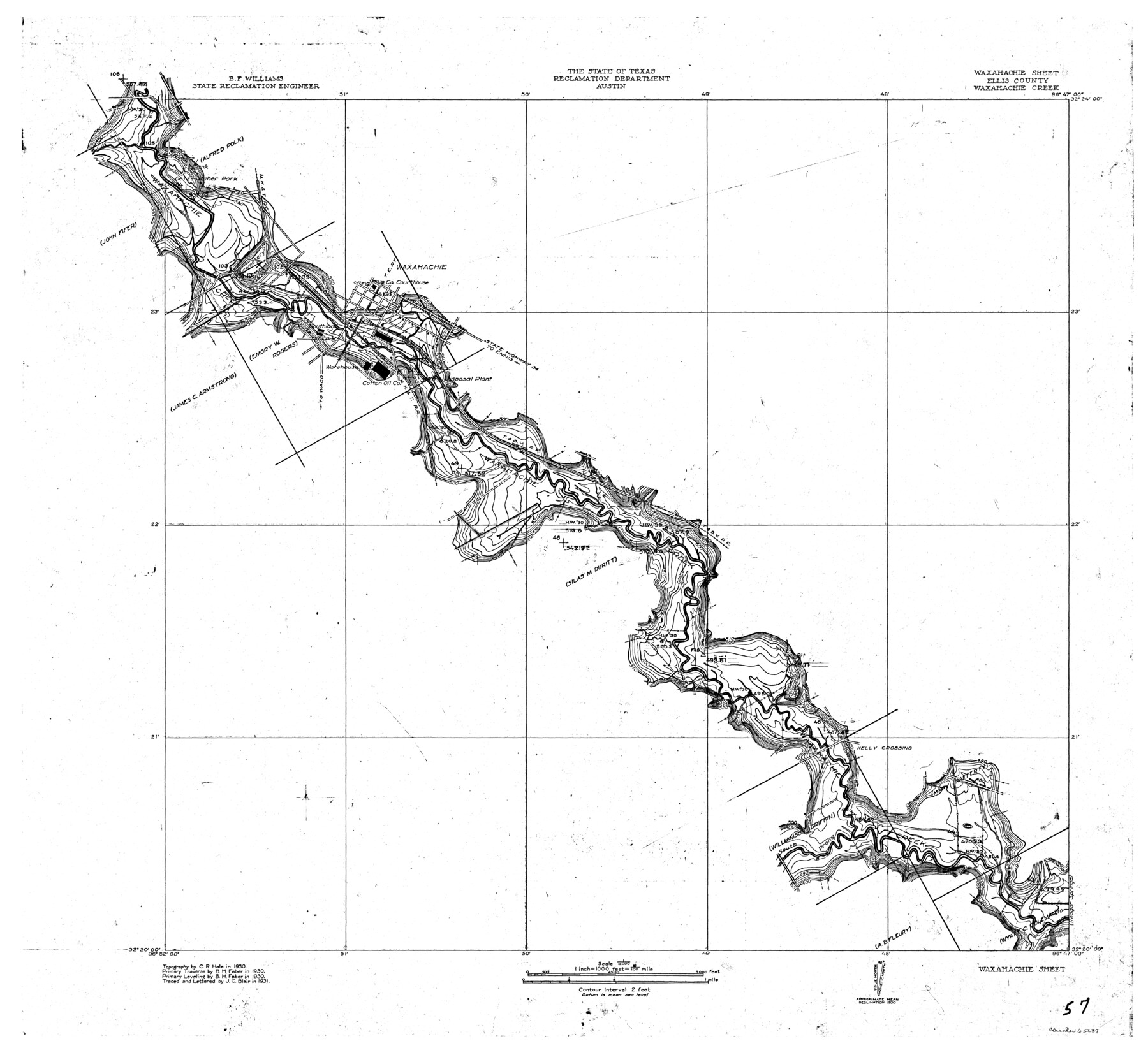
Trinity River, Waxahachie Sheet/Waxahachie Creek
-
Map/Doc
65237
-
Collection
General Map Collection
-
Object Dates
1931 (Creation Date)
-
People and Organizations
Texas State Reclamation Department (Publisher)
Curtis R. Hale (Surveyor/Engineer)
J.C. Blair (Draftsman)
J.C. Blair (Compiler)
B.H. Faber (Surveyor/Engineer)
-
Counties
Ellis
-
Subjects
River Surveys Topographic
-
Height x Width
30.1 x 32.8 inches
76.5 x 83.3 cm
-
Comments
Waxahachie Sheet located west of the Reagor Springs Sheet.
Part of: General Map Collection
San Patricio County Sketch File 24

Print $10.00
San Patricio County Sketch File 24
1918
Size 10.0 x 4.3 inches
Map/Doc 36078
Crane County Sketch File 19

Print $4.00
- Digital $50.00
Crane County Sketch File 19
1927
Size 11.4 x 8.8 inches
Map/Doc 19584
Flight Mission No. BQY-14M, Frame 184, Harris County

Print $20.00
- Digital $50.00
Flight Mission No. BQY-14M, Frame 184, Harris County
1953
Size 18.6 x 22.4 inches
Map/Doc 85300
Collingsworth County Working Sketch 2

Print $20.00
- Digital $50.00
Collingsworth County Working Sketch 2
1957
Size 42.5 x 20.1 inches
Map/Doc 63761
Flight Mission No. BQR-7K, Frame 27, Brazoria County

Print $20.00
- Digital $50.00
Flight Mission No. BQR-7K, Frame 27, Brazoria County
1952
Size 18.6 x 22.3 inches
Map/Doc 84025
Uvalde County Working Sketch 37

Print $20.00
- Digital $50.00
Uvalde County Working Sketch 37
1969
Size 26.7 x 34.0 inches
Map/Doc 72107
Travis County Rolled Sketch 29

Print $20.00
- Digital $50.00
Travis County Rolled Sketch 29
1946
Size 25.1 x 37.8 inches
Map/Doc 8031
Jim Wells County Working Sketch Graphic Index

Print $20.00
- Digital $50.00
Jim Wells County Working Sketch Graphic Index
1966
Size 41.7 x 29.5 inches
Map/Doc 76597
Hemphill County Working Sketch 26

Print $40.00
- Digital $50.00
Hemphill County Working Sketch 26
1974
Size 57.2 x 48.3 inches
Map/Doc 66121
Harrison County Working Sketch 17

Print $20.00
- Digital $50.00
Harrison County Working Sketch 17
1969
Size 38.1 x 38.0 inches
Map/Doc 66037
Fort Bend County Working Sketch 5

Print $20.00
- Digital $50.00
Fort Bend County Working Sketch 5
1915
Size 14.5 x 20.9 inches
Map/Doc 69211
Upton County Boundary File 1b

Print $28.00
- Digital $50.00
Upton County Boundary File 1b
Size 13.5 x 9.1 inches
Map/Doc 59512
You may also like
Stephens County Sketch File 5

Print $6.00
- Digital $50.00
Stephens County Sketch File 5
Size 10.0 x 13.3 inches
Map/Doc 37019
Crockett County Working Sketch 61

Print $20.00
- Digital $50.00
Crockett County Working Sketch 61
1955
Size 36.5 x 33.2 inches
Map/Doc 68394
Austin County Working Sketch 3

Print $20.00
- Digital $50.00
Austin County Working Sketch 3
1950
Size 33.3 x 40.1 inches
Map/Doc 67244
Hall County Sketch File B2

Print $20.00
- Digital $50.00
Hall County Sketch File B2
1904
Size 21.7 x 35.1 inches
Map/Doc 11613
Armstrong County Sketch File 9

Print $12.00
- Digital $50.00
Armstrong County Sketch File 9
1904
Size 11.6 x 9.1 inches
Map/Doc 41460
Map of Texas with population and location of principal towns and cities according to latest reliable statistics

Print $20.00
- Digital $50.00
Map of Texas with population and location of principal towns and cities according to latest reliable statistics
1921
Size 19.0 x 22.2 inches
Map/Doc 94066
Map Showing the Distribution of the Slave Population of the Southern States of the United States

Map Showing the Distribution of the Slave Population of the Southern States of the United States
2022
Size 8.5 x 11.0 inches
Map/Doc 96677

Hood County Working Sketch 2

Print $20.00
- Digital $50.00
Hood County Working Sketch 2
1956
Size 20.5 x 25.5 inches
Map/Doc 66196
Matagorda County Working Sketch 10

Print $20.00
- Digital $50.00
Matagorda County Working Sketch 10
1958
Size 27.8 x 33.3 inches
Map/Doc 70868
Reagan County Rolled Sketch 17

Print $20.00
- Digital $50.00
Reagan County Rolled Sketch 17
Size 33.9 x 32.6 inches
Map/Doc 10623
Map of Part of Espiritu Santo and San Antonio Bays and Vicinity, Texas

Print $40.00
- Digital $50.00
Map of Part of Espiritu Santo and San Antonio Bays and Vicinity, Texas
1859
Size 31.6 x 53.1 inches
Map/Doc 69983