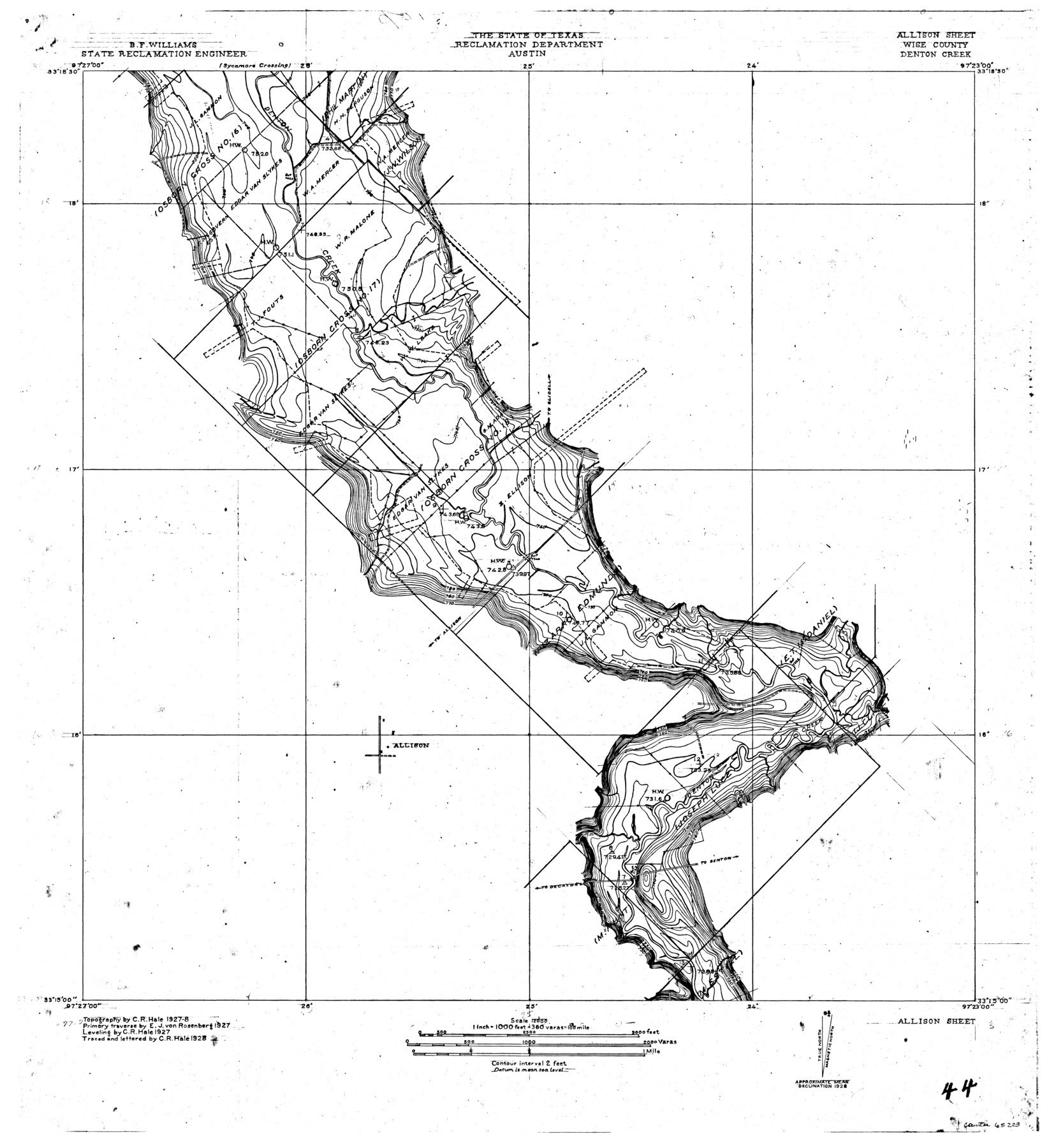
Trinity River, Allison Sheet/Denton Creek
-
Map/Doc
65223
-
Collection
General Map Collection
-
Object Dates
1928 (Creation Date)
-
People and Organizations
Texas State Reclamation Department (Publisher)
Curtis R. Hale (Compiler)
Curtis R. Hale (Draftsman)
Curtis R. Hale (Surveyor/Engineer)
E.J. von Rosenberg (Surveyor/Engineer)
-
Counties
Wise
-
Subjects
River Surveys Topographic
-
Height x Width
26.3 x 24.2 inches
66.8 x 61.5 cm
-
Comments
Allison Sheet located south of Sycamore Crossing Sheet.
Part of: General Map Collection
McMullen County Rolled Sketch 5

Print $20.00
- Digital $50.00
McMullen County Rolled Sketch 5
Size 46.4 x 26.8 inches
Map/Doc 6723
Calhoun County Rolled Sketch 14

Print $20.00
- Digital $50.00
Calhoun County Rolled Sketch 14
Size 22.2 x 40.7 inches
Map/Doc 5455
Flight Mission No. CGI-3N, Frame 133, Cameron County

Print $20.00
- Digital $50.00
Flight Mission No. CGI-3N, Frame 133, Cameron County
1954
Size 18.5 x 22.1 inches
Map/Doc 84606
Bowie County Sketch File 9

Print $10.00
- Digital $50.00
Bowie County Sketch File 9
Size 8.1 x 3.9 inches
Map/Doc 14907
Zavala County Working Sketch 3

Print $20.00
- Digital $50.00
Zavala County Working Sketch 3
1912
Size 37.1 x 46.9 inches
Map/Doc 62078
Dickens County Sketch File H3

Print $10.00
- Digital $50.00
Dickens County Sketch File H3
1904
Size 10.9 x 8.5 inches
Map/Doc 20876

San Patricio County Sketch File 52

Print $14.00
- Digital $50.00
San Patricio County Sketch File 52
1917
Size 11.3 x 8.7 inches
Map/Doc 36381
Cooke County Sketch File 33

Print $44.00
- Digital $50.00
Cooke County Sketch File 33
1873
Size 13.4 x 26.5 inches
Map/Doc 11174
Sutton County Boundary File 2a

Print $20.00
- Digital $50.00
Sutton County Boundary File 2a
Size 8.6 x 6.3 inches
Map/Doc 59014
Flight Mission No. DIX-5P, Frame 117, Aransas County

Print $20.00
- Digital $50.00
Flight Mission No. DIX-5P, Frame 117, Aransas County
1956
Size 18.0 x 17.7 inches
Map/Doc 83796
Zavalla County

Print $20.00
- Digital $50.00
Zavalla County
1879
Size 21.3 x 25.0 inches
Map/Doc 4645
You may also like
Harrison County Sketch File 14

Print $32.00
- Digital $50.00
Harrison County Sketch File 14
1880
Size 11.2 x 8.8 inches
Map/Doc 26053
Real County Working Sketch 54

Print $20.00
- Digital $50.00
Real County Working Sketch 54
1960
Size 31.0 x 39.5 inches
Map/Doc 71946
Navigation Maps of Gulf Intracoastal Waterway, Port Arthur to Brownsville, Texas

Print $4.00
- Digital $50.00
Navigation Maps of Gulf Intracoastal Waterway, Port Arthur to Brownsville, Texas
1951
Size 16.7 x 21.5 inches
Map/Doc 65441
Map of Texas and Parts of Adjoining Territories

Print $20.00
Map of Texas and Parts of Adjoining Territories
1899
Size 33.7 x 36.0 inches
Map/Doc 79304
Presidio County Working Sketch 114

Print $40.00
- Digital $50.00
Presidio County Working Sketch 114
1981
Size 63.9 x 37.9 inches
Map/Doc 71791
Jeff Davis County Rolled Sketch 33

Print $20.00
- Digital $50.00
Jeff Davis County Rolled Sketch 33
1986
Size 39.8 x 30.6 inches
Map/Doc 6379
San Saba County Sketch File 6

Print $6.00
- Digital $50.00
San Saba County Sketch File 6
1881
Size 10.9 x 8.4 inches
Map/Doc 36414
[Leagues 615, 616, and vicinity]
![91004, [Leagues 615, 616, and vicinity], Twichell Survey Records](https://historictexasmaps.com/wmedia_w700/maps/91004-1.tif.jpg)
Print $20.00
- Digital $50.00
[Leagues 615, 616, and vicinity]
Size 12.9 x 12.3 inches
Map/Doc 91004
Nacogdoches County Sketch File 20

Print $26.00
- Digital $50.00
Nacogdoches County Sketch File 20
Size 12.6 x 7.9 inches
Map/Doc 32275
Jack County Working Sketch 3

Print $20.00
- Digital $50.00
Jack County Working Sketch 3
1940
Size 18.8 x 26.0 inches
Map/Doc 66429
Webb County Working Sketch 45

Print $20.00
- Digital $50.00
Webb County Working Sketch 45
1944
Size 28.1 x 28.9 inches
Map/Doc 72410
Uvalde County Working Sketch 42

Print $20.00
- Digital $50.00
Uvalde County Working Sketch 42
1978
Size 34.5 x 27.9 inches
Map/Doc 72112