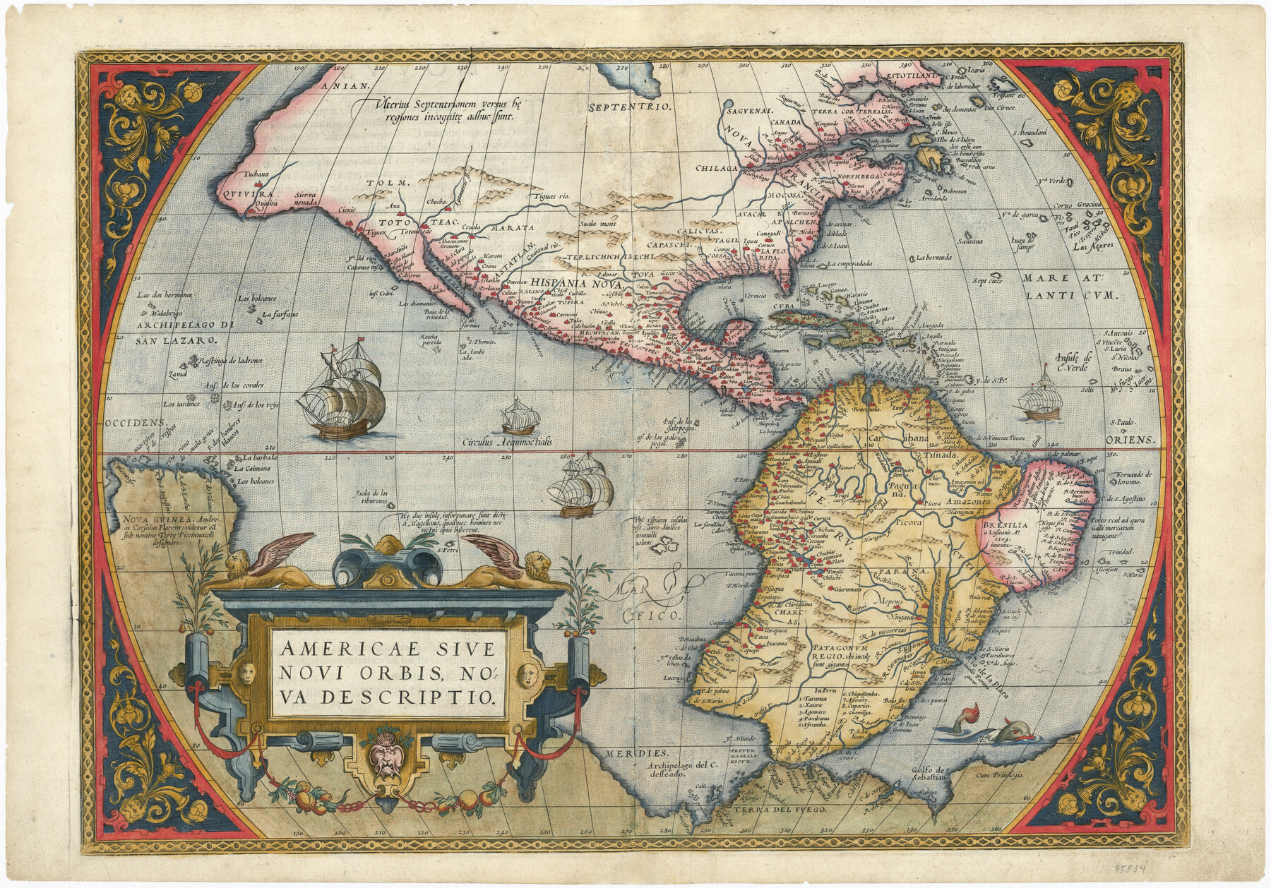
Americae Sive Novi Orbis, Nova Descriptio
-
Map/Doc
95834
-
Collection
General Map Collection
-
Object Dates
[1573] (Creation Date)
-
People and Organizations
Abraham Ortelius (Cartographer)
-
Subjects
North America South America
-
Height x Width
15.6 x 22.3 inches
39.6 x 56.6 cm
-
Medium
paper, etching/engraving/lithograph
-
Comments
From Ortelius' "Theatrum Orbis Terrarum". To view content on verso, click "Download PDF" link above.
Part of: General Map Collection
Pecos County Sketch File 85

Print $19.00
- Digital $50.00
Pecos County Sketch File 85
1948
Size 14.6 x 9.2 inches
Map/Doc 33955
Moore County Working Sketch 1

Print $20.00
- Digital $50.00
Moore County Working Sketch 1
1909
Size 32.0 x 32.4 inches
Map/Doc 71183
Medina County Working Sketch 32

Print $20.00
- Digital $50.00
Medina County Working Sketch 32
1994
Size 30.4 x 42.4 inches
Map/Doc 70947
[Capitol League Surveys in Hartley County, Texas]
![1766, [Capitol League Surveys in Hartley County, Texas], General Map Collection](https://historictexasmaps.com/wmedia_w700/maps/1766.tif.jpg)
Print $20.00
- Digital $50.00
[Capitol League Surveys in Hartley County, Texas]
1910
Size 19.6 x 27.9 inches
Map/Doc 1766

Jackson County

Print $40.00
- Digital $50.00
Jackson County
1920
Size 49.5 x 41.8 inches
Map/Doc 66878
Runnels County Sketch File 19 and 22

Print $48.00
Runnels County Sketch File 19 and 22
1887
Size 14.0 x 21.2 inches
Map/Doc 12254
Orange County Sketch File 9a

Print $4.00
- Digital $50.00
Orange County Sketch File 9a
1873
Size 8.1 x 7.5 inches
Map/Doc 33313
Gulf Coast of the United States, Key West to Rio Grande

Print $20.00
- Digital $50.00
Gulf Coast of the United States, Key West to Rio Grande
1863
Size 27.4 x 18.3 inches
Map/Doc 72666
Flight Mission No. BRA-3M, Frame 123, Jefferson County

Print $20.00
- Digital $50.00
Flight Mission No. BRA-3M, Frame 123, Jefferson County
1953
Size 18.5 x 21.7 inches
Map/Doc 85397
Aransas County Rolled Sketch 1

Print $40.00
- Digital $50.00
Aransas County Rolled Sketch 1
1930
Size 11.5 x 49.5 inches
Map/Doc 10685
El Paso County Sketch File 35 (2)

Print $18.00
- Digital $50.00
El Paso County Sketch File 35 (2)
1886
Size 12.9 x 8.3 inches
Map/Doc 22170
You may also like
Morris County Rolled Sketch 2A

Print $20.00
- Digital $50.00
Morris County Rolled Sketch 2A
Size 13.4 x 19.1 inches
Map/Doc 10231
Dickens County Sketch File D

Print $20.00
- Digital $50.00
Dickens County Sketch File D
1883
Size 15.7 x 14.8 inches
Map/Doc 11330
Brewster County Rolled Sketch 6

Print $40.00
- Digital $50.00
Brewster County Rolled Sketch 6
Size 43.0 x 66.2 inches
Map/Doc 75944
[H. &GN Blk. 2, HGN Blk. 1, I, S]
![93212, [H. &GN Blk. 2, HGN Blk. 1, I, S], Twichell Survey Records](https://historictexasmaps.com/wmedia_w700/maps/93212-1.tif.jpg)
Print $40.00
- Digital $50.00
[H. &GN Blk. 2, HGN Blk. 1, I, S]
Size 84.0 x 53.3 inches
Map/Doc 93212
Coryell County Working Sketch 1

Print $20.00
- Digital $50.00
Coryell County Working Sketch 1
1906
Size 14.7 x 12.9 inches
Map/Doc 68208
[Sketch for Mineral Application 24072, San Jacinto River]
![65586, [Sketch for Mineral Application 24072, San Jacinto River], General Map Collection](https://historictexasmaps.com/wmedia_w700/maps/65586.tif.jpg)
Print $20.00
- Digital $50.00
[Sketch for Mineral Application 24072, San Jacinto River]
1929
Size 18.0 x 20.3 inches
Map/Doc 65586
Williamson County Rolled Sketch 8

Print $20.00
- Digital $50.00
Williamson County Rolled Sketch 8
Size 15.1 x 18.0 inches
Map/Doc 8265
The Yellow Rose Compass

Price $20.00
The Yellow Rose Compass
2025
Size 3.5 x 2.8 inches
Map/Doc 97508
Roberts County Working Sketch 39

Print $20.00
- Digital $50.00
Roberts County Working Sketch 39
1978
Size 26.6 x 22.7 inches
Map/Doc 63565

Dawson County Sketch File 10

Print $4.00
- Digital $50.00
Dawson County Sketch File 10
1927
Size 11.4 x 8.8 inches
Map/Doc 20544
Township 2 South Range 11 West, South Western District, Louisiana

Print $20.00
- Digital $50.00
Township 2 South Range 11 West, South Western District, Louisiana
1882
Size 19.6 x 24.6 inches
Map/Doc 65881