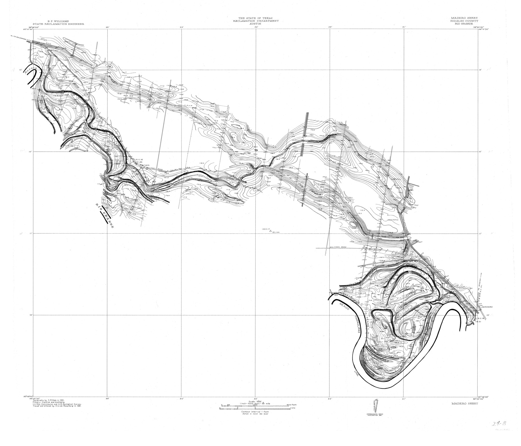
Rio Grande, Madero Sheet
-
Map/Doc
65124
-
Collection
General Map Collection
-
Object Dates
1931 (Creation Date)
-
People and Organizations
Texas State Reclamation Department (Publisher)
H.U. von Rosenberg (Draftsman)
H.U. von Rosenberg (Compiler)
C.R. Hale (Surveyor/Engineer)
-
Counties
Hidalgo
-
Subjects
River Surveys Topographic
-
Height x Width
33.0 x 38.5 inches
83.8 x 97.8 cm
Part of: General Map Collection
Williamson County Sketch File 7

Print $4.00
- Digital $50.00
Williamson County Sketch File 7
1847
Size 12.7 x 7.7 inches
Map/Doc 40316
Young Land District

Print $20.00
- Digital $50.00
Young Land District
1857
Size 21.7 x 29.7 inches
Map/Doc 1974
Anderson County Sketch File 13

Print $10.00
- Digital $50.00
Anderson County Sketch File 13
1856
Size 8.1 x 8.3 inches
Map/Doc 12774

Hall County Sketch File 6

Print $20.00
- Digital $50.00
Hall County Sketch File 6
1885
Size 28.2 x 37.9 inches
Map/Doc 10473
University Lands, Blocks 1-13 & Block 58, Crockett, Reagan & Upton Counties

Print $20.00
- Digital $50.00
University Lands, Blocks 1-13 & Block 58, Crockett, Reagan & Upton Counties
1936
Size 36.9 x 42.0 inches
Map/Doc 2409
Lamb County Sketch File C1

Print $20.00
- Digital $50.00
Lamb County Sketch File C1
1904
Size 26.5 x 21.7 inches
Map/Doc 11974
Sutton County Sketch File 33a-b

Print $7.00
- Digital $50.00
Sutton County Sketch File 33a-b
1934
Size 8.4 x 8.4 inches
Map/Doc 37469
Brewster County Rolled Sketch 9

Print $40.00
- Digital $50.00
Brewster County Rolled Sketch 9
Size 38.7 x 67.5 inches
Map/Doc 8468
Burnet County Rolled Sketch 5

Print $40.00
- Digital $50.00
Burnet County Rolled Sketch 5
1971
Size 36.5 x 49.6 inches
Map/Doc 8542
Shackelford County Working Sketch 9

Print $20.00
- Digital $50.00
Shackelford County Working Sketch 9
1974
Size 30.1 x 22.2 inches
Map/Doc 63849
Flight Mission No. BRA-8M, Frame 23, Jefferson County

Print $20.00
- Digital $50.00
Flight Mission No. BRA-8M, Frame 23, Jefferson County
1953
Size 18.7 x 22.3 inches
Map/Doc 85578
You may also like
[Sketch for Mineral Application 26546 - Sabine River between Hawkins Creek and east boundary line of BBB&C RR Co. Surveys, R. S. Rathke]
![65665, [Sketch for Mineral Application 26546 - Sabine River between Hawkins Creek and east boundary line of BBB&C RR Co. Surveys, R. S. Rathke], General Map Collection](https://historictexasmaps.com/wmedia_w700/maps/65665.tif.jpg)
Print $40.00
- Digital $50.00
[Sketch for Mineral Application 26546 - Sabine River between Hawkins Creek and east boundary line of BBB&C RR Co. Surveys, R. S. Rathke]
1931
Size 25.5 x 75.1 inches
Map/Doc 65665
Upton County Rolled Sketch 55

Print $40.00
- Digital $50.00
Upton County Rolled Sketch 55
Size 192.5 x 25.4 inches
Map/Doc 10060
Hemphill County, State of Texas

Print $20.00
- Digital $50.00
Hemphill County, State of Texas
1888
Size 22.0 x 17.4 inches
Map/Doc 6187
Flight Mission No. BRE-1P, Frame 33, Nueces County

Print $20.00
- Digital $50.00
Flight Mission No. BRE-1P, Frame 33, Nueces County
1956
Size 18.5 x 22.2 inches
Map/Doc 86629
National Map Company's Ohio showing Counties, Townships, Cities, Villages, Post Offices, Steam and Electric Railways, With Stations and Distances Between Stations

Print $20.00
- Digital $50.00
National Map Company's Ohio showing Counties, Townships, Cities, Villages, Post Offices, Steam and Electric Railways, With Stations and Distances Between Stations
1920
Size 38.7 x 32.3 inches
Map/Doc 97109
Flight Mission No. BRA-6M, Frame 83, Jefferson County

Print $20.00
- Digital $50.00
Flight Mission No. BRA-6M, Frame 83, Jefferson County
1953
Size 18.6 x 22.3 inches
Map/Doc 85427
Pecos County Working Sketch 78

Print $20.00
- Digital $50.00
Pecos County Working Sketch 78
1960
Size 29.4 x 34.4 inches
Map/Doc 71550
Map of Block 1, H. & G. N. Railroad Company

Print $20.00
- Digital $50.00
Map of Block 1, H. & G. N. Railroad Company
1909
Size 24.0 x 30.1 inches
Map/Doc 91017
Winkler County

Print $20.00
- Digital $50.00
Winkler County
1890
Size 22.8 x 18.5 inches
Map/Doc 4160
Flight Mission No. BRA-7M, Frame 148, Jefferson County

Print $20.00
- Digital $50.00
Flight Mission No. BRA-7M, Frame 148, Jefferson County
1953
Size 18.6 x 22.4 inches
Map/Doc 85542
Zapata County Boundary File 1

Print $2.00
- Digital $50.00
Zapata County Boundary File 1
Size 11.4 x 9.0 inches
Map/Doc 60227
Bell County Working Sketch 12

Print $20.00
- Digital $50.00
Bell County Working Sketch 12
1956
Size 17.2 x 22.0 inches
Map/Doc 67352