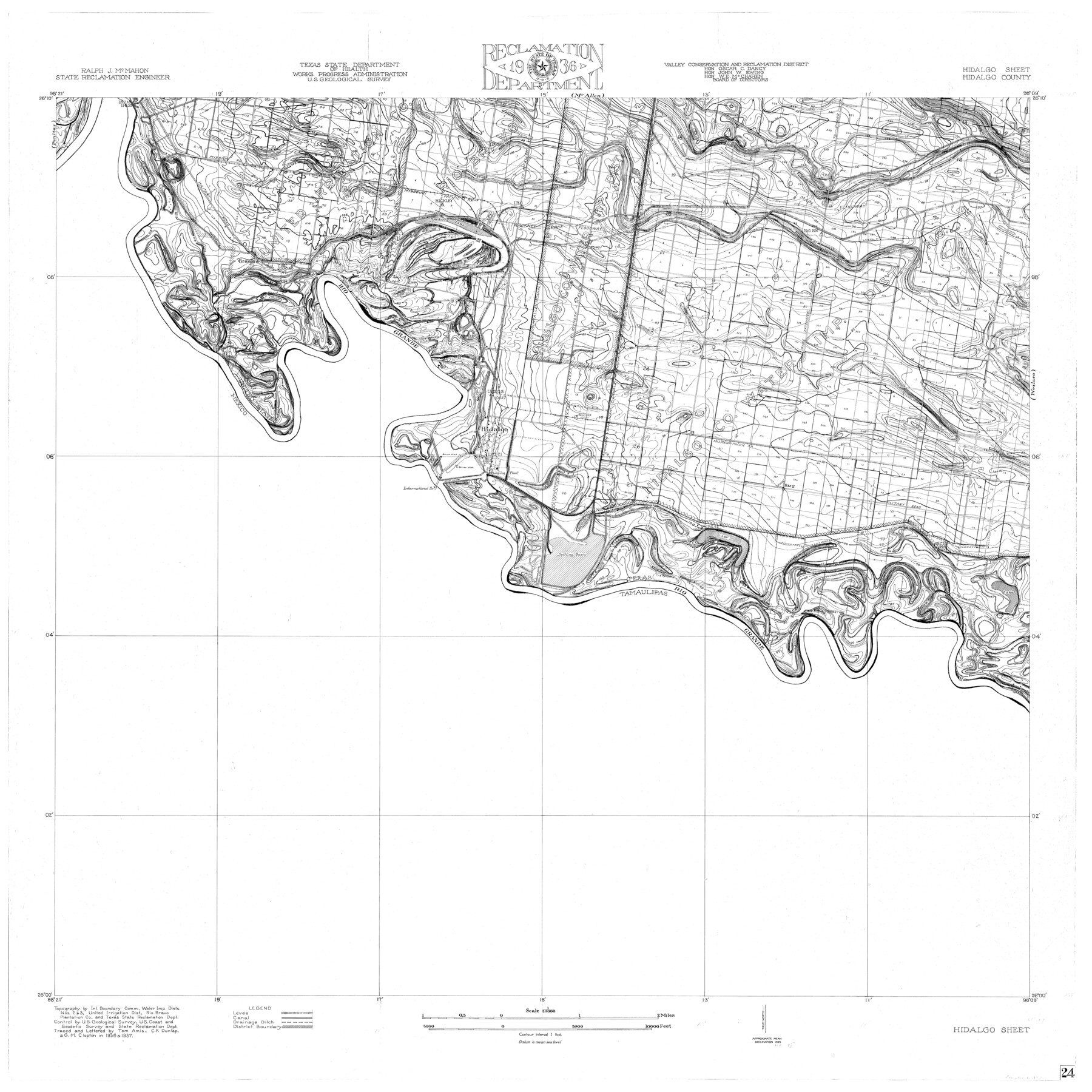
Rio Grande, Hidalgo Sheet
-
Map/Doc
65122
-
Collection
General Map Collection
-
Object Dates
1937 (Creation Date)
-
People and Organizations
Texas State Reclamation Department (Publisher)
Tom Amis (Draftsman)
Tom Amis (Compiler)
G.M. Clopton (Draftsman)
G.M. Clopton (Compiler)
C.F. Dunlap (Draftsman)
C.F. Dunlap (Compiler)
-
Counties
Hidalgo
-
Subjects
City River Surveys Topographic
-
Height x Width
36.8 x 36.8 inches
93.5 x 93.5 cm
Part of: General Map Collection
Flight Mission No. CRK-8P, Frame 102, Refugio County

Print $20.00
- Digital $50.00
Flight Mission No. CRK-8P, Frame 102, Refugio County
1956
Size 18.2 x 22.0 inches
Map/Doc 86963
Sketch A Shewing the progress of the Survey in Section No. 1 From 1844 to 1851

Print $20.00
- Digital $50.00
Sketch A Shewing the progress of the Survey in Section No. 1 From 1844 to 1851
1851
Size 37.1 x 24.5 inches
Map/Doc 97202
Jasper County Sketch File 24

Print $4.00
- Digital $50.00
Jasper County Sketch File 24
1925
Size 10.9 x 8.3 inches
Map/Doc 27824
Glasscock County Sketch File 17

Print $44.00
- Digital $50.00
Glasscock County Sketch File 17
1936
Size 11.4 x 8.8 inches
Map/Doc 24188
Jeff Davis County Rolled Sketch 21

Print $20.00
- Digital $50.00
Jeff Davis County Rolled Sketch 21
1946
Size 46.5 x 38.7 inches
Map/Doc 9267
Donley County Sketch File B6

Print $20.00
- Digital $50.00
Donley County Sketch File B6
1919
Size 16.5 x 14.6 inches
Map/Doc 11376
Map of Chicago, Rock Island & Texas Railway through Wise and Tarrant County, Texas

Print $40.00
- Digital $50.00
Map of Chicago, Rock Island & Texas Railway through Wise and Tarrant County, Texas
1893
Size 19.4 x 121.0 inches
Map/Doc 64428
Andrews County Rolled Sketch 19

Print $20.00
- Digital $50.00
Andrews County Rolled Sketch 19
1945
Size 23.3 x 28.1 inches
Map/Doc 77167
Wise County Sketch File 7

Print $4.00
- Digital $50.00
Wise County Sketch File 7
1857
Size 8.1 x 14.0 inches
Map/Doc 40535
Sabine Bank to East Bay including Heald Bank

Print $20.00
- Digital $50.00
Sabine Bank to East Bay including Heald Bank
1960
Size 45.1 x 34.3 inches
Map/Doc 69847
Flight Mission No. DQO-2K, Frame 134, Galveston County

Print $20.00
- Digital $50.00
Flight Mission No. DQO-2K, Frame 134, Galveston County
1952
Size 18.7 x 22.4 inches
Map/Doc 85031
Pecos County Rolled Sketch 165

Print $20.00
- Digital $50.00
Pecos County Rolled Sketch 165
1966
Size 23.4 x 19.6 inches
Map/Doc 7290
You may also like
Nueces County Sketch File 66

Print $18.00
- Digital $50.00
Nueces County Sketch File 66
1981
Size 14.3 x 8.8 inches
Map/Doc 32989
Flight Mission No. DAG-21K, Frame 125, Matagorda County

Print $20.00
- Digital $50.00
Flight Mission No. DAG-21K, Frame 125, Matagorda County
1952
Size 18.5 x 22.4 inches
Map/Doc 86451
Crockett County Sketch File 94

Print $6.00
- Digital $50.00
Crockett County Sketch File 94
1940
Size 9.2 x 12.3 inches
Map/Doc 19950
Jack County Sketch File 37

Print $4.00
- Digital $50.00
Jack County Sketch File 37
1963
Size 3.5 x 7.6 inches
Map/Doc 27615
Map of Concho County

Print $20.00
- Digital $50.00
Map of Concho County
1862
Size 21.7 x 18.2 inches
Map/Doc 3435
Baylor County Sketch File 7

Print $4.00
- Digital $50.00
Baylor County Sketch File 7
Size 6.7 x 10.2 inches
Map/Doc 14135
Roberts County Working Sketch 30

Print $20.00
- Digital $50.00
Roberts County Working Sketch 30
1983
Size 47.4 x 38.5 inches
Map/Doc 63556
Flight Mission No. CGI-4N, Frame 179, Cameron County

Print $20.00
- Digital $50.00
Flight Mission No. CGI-4N, Frame 179, Cameron County
1955
Size 18.5 x 22.2 inches
Map/Doc 84682

Flight Mission No. BRA-16M, Frame 171, Jefferson County

Print $20.00
- Digital $50.00
Flight Mission No. BRA-16M, Frame 171, Jefferson County
1953
Size 18.6 x 22.3 inches
Map/Doc 85769
Borden County Working Sketch 2

Print $20.00
- Digital $50.00
Borden County Working Sketch 2
1913
Size 24.6 x 18.4 inches
Map/Doc 67462
Sutton County Rolled Sketch 62

Print $40.00
- Digital $50.00
Sutton County Rolled Sketch 62
Size 69.8 x 45.2 inches
Map/Doc 9978