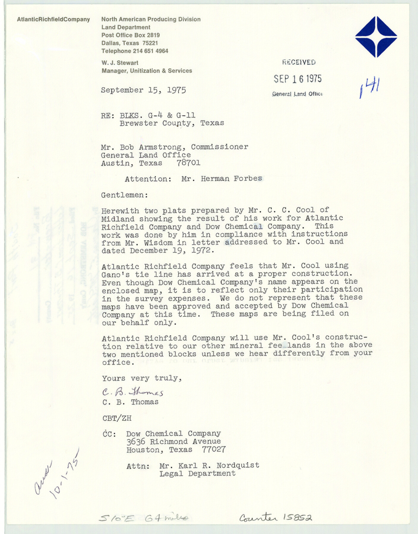
Brewster County Sketch File FN-31
[Letter from C.B. Thomas]
-
Map/Doc
15852
-
Collection
General Map Collection
-
Object Dates
1975/9/15 (Creation Date)
1975/9/16 (File Date)
-
People and Organizations
C.B. Thomas (Author)
-
Counties
Brewster
-
Subjects
Surveying Sketch File
-
Height x Width
11.3 x 8.8 inches
28.7 x 22.4 cm
-
Medium
paper, print
Part of: General Map Collection
Hill County Boundary File 45b

Print $60.00
- Digital $50.00
Hill County Boundary File 45b
Size 7.8 x 3.7 inches
Map/Doc 54772
Flight Mission No. BRE-2P, Frame 37, Nueces County

Print $20.00
- Digital $50.00
Flight Mission No. BRE-2P, Frame 37, Nueces County
1956
Size 18.4 x 22.4 inches
Map/Doc 86739
Nueces County NRC Article 33.136 Sketch 15

Print $40.00
- Digital $50.00
Nueces County NRC Article 33.136 Sketch 15
2012
Size 18.0 x 24.0 inches
Map/Doc 93357
Flight Mission No. DQN-5K, Frame 148, Calhoun County

Print $20.00
- Digital $50.00
Flight Mission No. DQN-5K, Frame 148, Calhoun County
1953
Size 18.6 x 21.9 inches
Map/Doc 84423
Crockett County Rolled Sketch 59

Print $20.00
- Digital $50.00
Crockett County Rolled Sketch 59
1946
Size 30.1 x 20.9 inches
Map/Doc 5602
Flight Mission No. CUG-1P, Frame 79, Kleberg County

Print $20.00
- Digital $50.00
Flight Mission No. CUG-1P, Frame 79, Kleberg County
1956
Size 18.7 x 22.2 inches
Map/Doc 86144
Intracoastal Waterway - Port Arthur to Galveston Bay

Print $20.00
- Digital $50.00
Intracoastal Waterway - Port Arthur to Galveston Bay
1961
Size 26.7 x 38.8 inches
Map/Doc 69834
Real County Rolled Sketch 5

Print $20.00
- Digital $50.00
Real County Rolled Sketch 5
Size 26.2 x 23.7 inches
Map/Doc 7455
Duval County Rolled Sketch 42

Print $20.00
- Digital $50.00
Duval County Rolled Sketch 42
1973
Size 23.6 x 29.8 inches
Map/Doc 5759
Morris County Rolled Sketch 2A

Print $20.00
- Digital $50.00
Morris County Rolled Sketch 2A
Size 24.1 x 19.0 inches
Map/Doc 10279
Duval County Sketch File 7

Print $4.00
- Digital $50.00
Duval County Sketch File 7
1875
Size 10.9 x 8.6 inches
Map/Doc 21294
Houston County Sketch File 1a

Print $4.00
- Digital $50.00
Houston County Sketch File 1a
Size 9.2 x 7.8 inches
Map/Doc 26742
You may also like
Erath County Working Sketch 16

Print $20.00
- Digital $50.00
Erath County Working Sketch 16
1961
Size 20.9 x 26.5 inches
Map/Doc 69097
Swisher County Working Sketch 6

Print $20.00
- Digital $50.00
Swisher County Working Sketch 6
1979
Size 23.2 x 19.7 inches
Map/Doc 62417
Brown County Sketch File 29

Print $6.00
- Digital $50.00
Brown County Sketch File 29
1924
Size 14.3 x 8.9 inches
Map/Doc 16628
Harris County Rolled Sketch 88

Print $20.00
- Digital $50.00
Harris County Rolled Sketch 88
1935
Size 34.4 x 22.7 inches
Map/Doc 6122
Map Showing Proposed System of State Highways as Adopted June 1917

Print $20.00
Map Showing Proposed System of State Highways as Adopted June 1917
1917
Size 20.9 x 22.4 inches
Map/Doc 76294
Brewster County Sketch File 50

Print $32.00
- Digital $50.00
Brewster County Sketch File 50
1995
Size 14.8 x 8.5 inches
Map/Doc 16336
Flight Mission No. BRA-9M, Frame 78, Jefferson County

Print $20.00
- Digital $50.00
Flight Mission No. BRA-9M, Frame 78, Jefferson County
1953
Size 18.5 x 22.5 inches
Map/Doc 85661
Martin County Working Sketch 3

Print $20.00
- Digital $50.00
Martin County Working Sketch 3
1950
Size 40.9 x 46.2 inches
Map/Doc 70821

Texas State Boundary Line 2

Print $116.00
- Digital $50.00
Texas State Boundary Line 2
1913
Size 11.2 x 8.8 inches
Map/Doc 73644
Aransas County Rolled Sketch 25

Print $20.00
- Digital $50.00
Aransas County Rolled Sketch 25
1983
Size 18.4 x 24.5 inches
Map/Doc 5061
Map of Capitol Syndicate Subdivisions of Capitol Land Reservation Leagues

Print $40.00
- Digital $50.00
Map of Capitol Syndicate Subdivisions of Capitol Land Reservation Leagues
1906
Size 44.6 x 72.6 inches
Map/Doc 93131