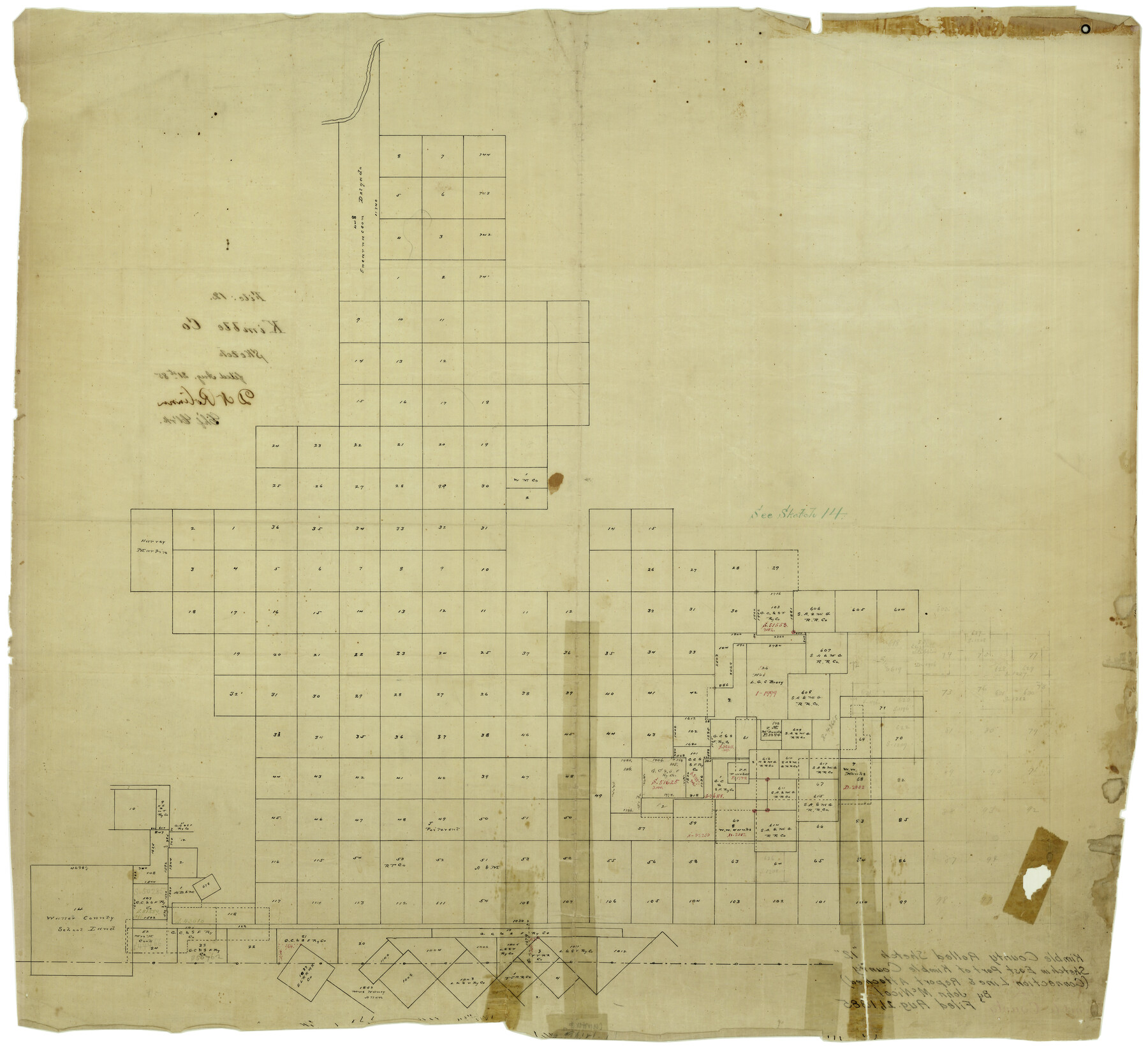
Kimble County Rolled Sketch 12
[Sketch in east part of Kimble County]
-
Map/Doc
6507
-
Collection
General Map Collection
-
Object Dates
8/21/1885 (File Date)
-
People and Organizations
John McNicol (Surveyor/Engineer)
-
Counties
Kimble
-
Subjects
Surveying Rolled Sketch
-
Height x Width
24.6 x 26.2 inches
62.5 x 66.6 cm
-
Medium
linen, manuscript
-
Comments
See Kimble County Sketch File 39 (28997) for connection line and report.
Related maps
Kimble County Sketch File 39

Print $12.00
- Digital $50.00
Kimble County Sketch File 39
1885
Size 14.1 x 8.6 inches
Map/Doc 28997
Part of: General Map Collection
Val Verde County Boundary File 104

Print $32.00
- Digital $50.00
Val Verde County Boundary File 104
Size 5.8 x 4.6 inches
Map/Doc 59604
Camp County Working Sketch 4

Print $20.00
- Digital $50.00
Camp County Working Sketch 4
2003
Size 31.6 x 25.3 inches
Map/Doc 82432
Wilson County Sketch File 8

Print $8.00
- Digital $50.00
Wilson County Sketch File 8
1879
Size 10.4 x 8.2 inches
Map/Doc 40413
Denton County Working Sketch 8

Print $20.00
- Digital $50.00
Denton County Working Sketch 8
1959
Size 37.4 x 30.8 inches
Map/Doc 68613
Bailey County Working Sketch 2

Print $20.00
- Digital $50.00
Bailey County Working Sketch 2
1920
Size 17.8 x 16.2 inches
Map/Doc 67589
Gulf of Mexico

Print $20.00
- Digital $50.00
Gulf of Mexico
1900
Size 18.2 x 28.1 inches
Map/Doc 72647
Hays County Sketch File A

Print $6.00
- Digital $50.00
Hays County Sketch File A
1881
Size 10.8 x 8.4 inches
Map/Doc 26186
Map of Bowie County

Print $20.00
- Digital $50.00
Map of Bowie County
1884
Size 19.4 x 23.7 inches
Map/Doc 3319
Jim Hogg County Working Sketch Graphic Index

Print $20.00
- Digital $50.00
Jim Hogg County Working Sketch Graphic Index
1962
Size 40.0 x 28.7 inches
Map/Doc 76596
Crockett County Working Sketch 87

Print $20.00
- Digital $50.00
Crockett County Working Sketch 87
1976
Size 35.5 x 43.8 inches
Map/Doc 68420
Brewster County Sketch File N-3c

Print $4.00
- Digital $50.00
Brewster County Sketch File N-3c
Size 12.7 x 8.4 inches
Map/Doc 15594
Flight Mission No. CRC-3R, Frame 14, Chambers County

Print $20.00
- Digital $50.00
Flight Mission No. CRC-3R, Frame 14, Chambers County
1956
Size 18.6 x 22.3 inches
Map/Doc 84788
You may also like
Trinity River, Clear Lake Sheet/East Fork of Trinity River and Pilot Grove Creek

Print $6.00
- Digital $50.00
Trinity River, Clear Lake Sheet/East Fork of Trinity River and Pilot Grove Creek
1923
Size 33.0 x 31.1 inches
Map/Doc 65194

Connected Map of Austin's Colony

Print $40.00
- Digital $50.00
Connected Map of Austin's Colony
1837
Size 93.2 x 43.7 inches
Map/Doc 93377
Borden County Working Sketch of Geo. Spiller's Resurvey of Block 97 made in 1887

Print $3.00
- Digital $50.00
Borden County Working Sketch of Geo. Spiller's Resurvey of Block 97 made in 1887
1903
Size 10.1 x 16.6 inches
Map/Doc 90211
McMullen County, Texas

Print $20.00
- Digital $50.00
McMullen County, Texas
1889
Size 28.7 x 22.1 inches
Map/Doc 575
Flight Mission No. BRA-7M, Frame 84, Jefferson County

Print $20.00
- Digital $50.00
Flight Mission No. BRA-7M, Frame 84, Jefferson County
1953
Size 18.6 x 22.3 inches
Map/Doc 85506
Kleberg County Rolled Sketch 10-38

Print $20.00
- Digital $50.00
Kleberg County Rolled Sketch 10-38
1952
Size 36.5 x 30.8 inches
Map/Doc 9372
School District No. 5, Armstrong County, Texas

Print $20.00
- Digital $50.00
School District No. 5, Armstrong County, Texas
1908
Size 15.5 x 20.2 inches
Map/Doc 90271
The Republic County of Washington. January 15, 1842

Print $20.00
The Republic County of Washington. January 15, 1842
2020
Size 11.8 x 21.7 inches
Map/Doc 96306

Railroad Track Map, H&TCRRCo., Falls County, Texas

Print $4.00
- Digital $50.00
Railroad Track Map, H&TCRRCo., Falls County, Texas
1918
Size 11.8 x 18.5 inches
Map/Doc 62837
Map of Encinal County

Print $20.00
- Digital $50.00
Map of Encinal County
1872
Size 30.5 x 20.3 inches
Map/Doc 3513