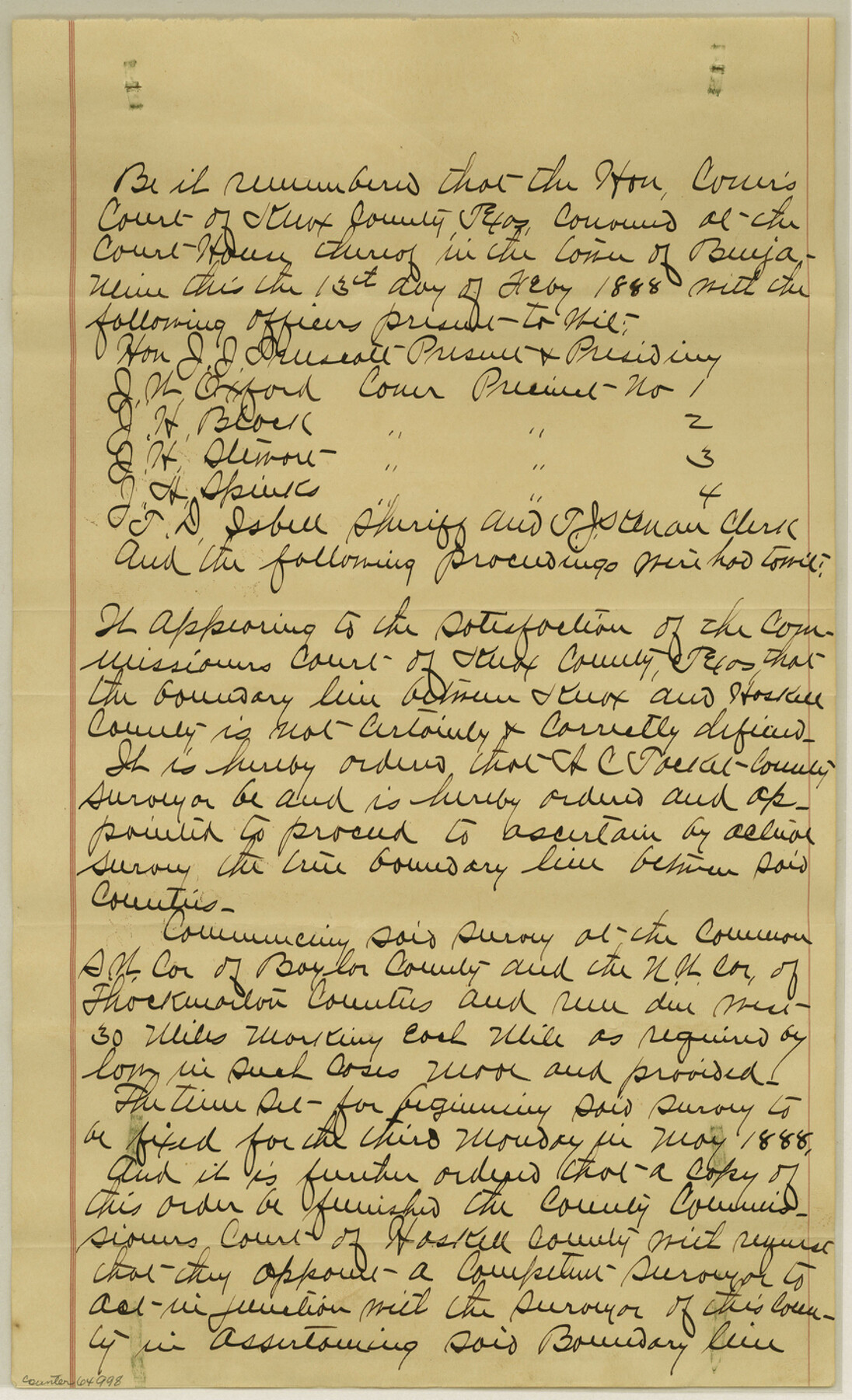
Knox County Boundary File 1
[Court Order and Fieldnotes of the south Boundary line of Knox County]
-
Map/Doc
64998
-
Collection
General Map Collection
-
Counties
Knox
-
Subjects
County Boundaries
-
Height x Width
14.2 x 8.6 inches
36.1 x 21.8 cm
Part of: General Map Collection
Newton County Sketch File 37

Print $6.00
- Digital $50.00
Newton County Sketch File 37
Size 16.2 x 10.7 inches
Map/Doc 32415
Culberson County Sketch File 17

Print $10.00
- Digital $50.00
Culberson County Sketch File 17
1932
Size 11.2 x 8.8 inches
Map/Doc 20180
Matagorda County Aerial Photograph Index Sheet 5

Print $20.00
- Digital $50.00
Matagorda County Aerial Photograph Index Sheet 5
1953
Size 23.6 x 19.5 inches
Map/Doc 83726

Val Verde County Working Sketch 110

Print $20.00
- Digital $50.00
Val Verde County Working Sketch 110
1990
Size 46.3 x 42.9 inches
Map/Doc 72245
Houston County Rolled Sketch 5

Print $20.00
- Digital $50.00
Houston County Rolled Sketch 5
1960
Size 28.3 x 40.8 inches
Map/Doc 6227
Nolan County Boundary File 2

Print $52.00
- Digital $50.00
Nolan County Boundary File 2
Size 8.7 x 8.1 inches
Map/Doc 57649
Upton County Working Sketch 39

Print $20.00
- Digital $50.00
Upton County Working Sketch 39
1958
Size 25.4 x 30.1 inches
Map/Doc 69535
Bandera County Sketch File 24

Print $4.00
- Digital $50.00
Bandera County Sketch File 24
Size 9.3 x 8.3 inches
Map/Doc 14014
Ector County Boundary File 4

Print $4.00
- Digital $50.00
Ector County Boundary File 4
Size 13.3 x 8.2 inches
Map/Doc 52845
Palo Pinto County Working Sketch 4

Print $20.00
- Digital $50.00
Palo Pinto County Working Sketch 4
1913
Map/Doc 71387
Childress County Sketch File 17

Print $8.00
- Digital $50.00
Childress County Sketch File 17
Size 13.0 x 8.2 inches
Map/Doc 18286
You may also like
Kaufman County Boundary File 6

Print $14.00
- Digital $50.00
Kaufman County Boundary File 6
Size 11.2 x 8.7 inches
Map/Doc 55956
General Land Office Reference Book: Burnet's, Vehlein's, Zavala's, Robertson's Colonies in Texas

General Land Office Reference Book: Burnet's, Vehlein's, Zavala's, Robertson's Colonies in Texas
Map/Doc 94555
Matagorda County Working Sketch 7

Print $20.00
- Digital $50.00
Matagorda County Working Sketch 7
1953
Size 41.0 x 31.8 inches
Map/Doc 70865

Revised Sectional Map Number 2, Lands in Texas and Pacific Railway Reservation From Westbrook Station in Mitchell County to Metz Station in Ector County

Print $20.00
- Digital $50.00
Revised Sectional Map Number 2, Lands in Texas and Pacific Railway Reservation From Westbrook Station in Mitchell County to Metz Station in Ector County
Size 25.1 x 19.6 inches
Map/Doc 91366
Schleicher County Rolled Sketch 14

Print $20.00
- Digital $50.00
Schleicher County Rolled Sketch 14
1952
Size 37.3 x 34.0 inches
Map/Doc 9905
Concho County Sketch File 44

Print $6.00
- Digital $50.00
Concho County Sketch File 44
1952
Size 14.3 x 8.8 inches
Map/Doc 19207
United States Population Distribution by County and Territory, per the U.S. Census of 1900

United States Population Distribution by County and Territory, per the U.S. Census of 1900
2025
Size 8.5 x 11.0 inches
Map/Doc 97481
Webb County Sketch File 11b-1

Print $20.00
- Digital $50.00
Webb County Sketch File 11b-1
1880
Size 21.7 x 19.3 inches
Map/Doc 12627
Lubbock County Working Sketch 9

Print $40.00
- Digital $50.00
Lubbock County Working Sketch 9
1990
Size 28.5 x 57.3 inches
Map/Doc 70669
Map of Hopkins County

Print $20.00
- Digital $50.00
Map of Hopkins County
1872
Size 16.3 x 18.1 inches
Map/Doc 3678
Map of Jasper County

Print $40.00
- Digital $50.00
Map of Jasper County
1898
Size 48.6 x 39.2 inches
Map/Doc 4990