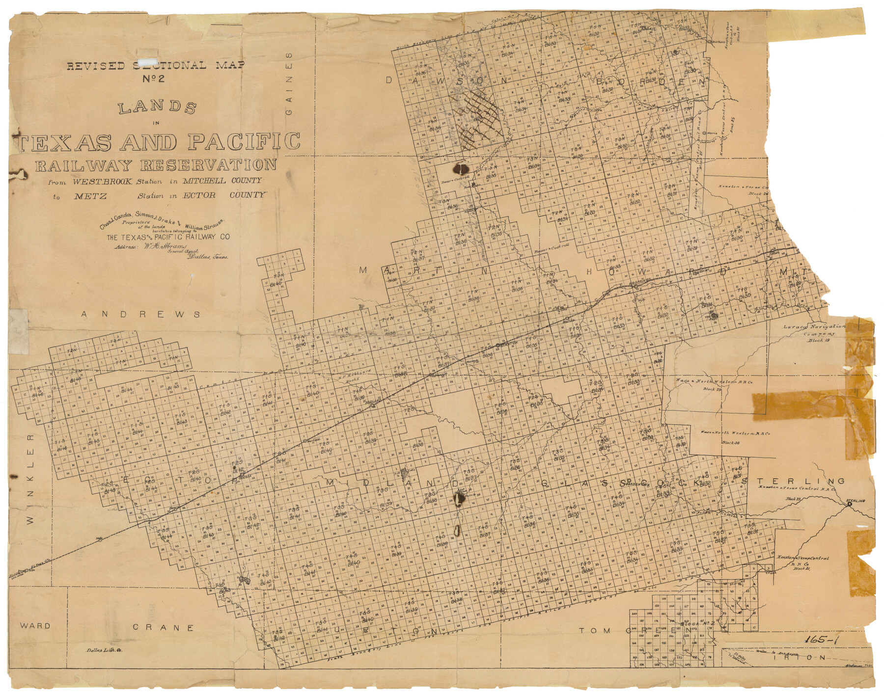
Revised Sectional Map Number 2, Lands in Texas and Pacific Railway Reservation From Westbrook Station in Mitchell County to Metz Station in Ector County
165-1
Part of: Twichell Survey Records
Subdivision Map of Childress County School Land situated in Bailey and Cochran Counties, Tex.

Print $20.00
- Digital $50.00
Subdivision Map of Childress County School Land situated in Bailey and Cochran Counties, Tex.
Size 22.8 x 26.2 inches
Map/Doc 90200
[Section 2, Block S]
![92860, [Section 2, Block S], Twichell Survey Records](https://historictexasmaps.com/wmedia_w700/maps/92860-1.tif.jpg)
Print $20.00
- Digital $50.00
[Section 2, Block S]
1958
Size 22.2 x 6.8 inches
Map/Doc 92860
[T. & N. O. RR. Block 1T]
![91902, [T. & N. O. RR. Block 1T], Twichell Survey Records](https://historictexasmaps.com/wmedia_w700/maps/91902-1.tif.jpg)
Print $20.00
- Digital $50.00
[T. & N. O. RR. Block 1T]
Size 14.9 x 20.0 inches
Map/Doc 91902
J. E. and J. W. Rhea's Ranch situated in Parmer Co., Texas

Print $20.00
- Digital $50.00
J. E. and J. W. Rhea's Ranch situated in Parmer Co., Texas
Size 23.2 x 24.3 inches
Map/Doc 91607
Working Sketch in Bastrop County

Print $20.00
- Digital $50.00
Working Sketch in Bastrop County
1923
Size 32.6 x 37.9 inches
Map/Doc 90147

[T. & P. Blocks 31-33, Township 5N]
![90568, [T. & P. Blocks 31-33, Township 5N], Twichell Survey Records](https://historictexasmaps.com/wmedia_w700/maps/90568-1.tif.jpg)
Print $20.00
- Digital $50.00
[T. & P. Blocks 31-33, Township 5N]
Size 14.6 x 17.7 inches
Map/Doc 90568
Reagan County Working Sketch

Print $20.00
- Digital $50.00
Reagan County Working Sketch
1923
Size 27.0 x 17.5 inches
Map/Doc 92971
[In Northwest 1/4 of County in the vicinity of the John Walker Survey]
![90910, [In Northwest 1/4 of County in the vicinity of the John Walker Survey], Twichell Survey Records](https://historictexasmaps.com/wmedia_w700/maps/90910-1.tif.jpg)
Print $20.00
- Digital $50.00
[In Northwest 1/4 of County in the vicinity of the John Walker Survey]
Size 15.2 x 23.9 inches
Map/Doc 90910
Scurry County North Snyder Area

Print $20.00
- Digital $50.00
Scurry County North Snyder Area
1949
Size 32.7 x 23.6 inches
Map/Doc 92920
[Portion of R. M. Thompson Blocks 1 and 2]
![91122, [Portion of R. M. Thompson Blocks 1 and 2], Twichell Survey Records](https://historictexasmaps.com/wmedia_w700/maps/91122-1.tif.jpg)
Print $3.00
- Digital $50.00
[Portion of R. M. Thompson Blocks 1 and 2]
Size 9.5 x 11.7 inches
Map/Doc 91122
[Map of Texas Panhandle Counties and Adjacent New Mexico Counties]
![89906, [Map of Texas Panhandle Counties and Adjacent New Mexico Counties], Twichell Survey Records](https://historictexasmaps.com/wmedia_w700/maps/89906-2.tif.jpg)
Print $40.00
- Digital $50.00
[Map of Texas Panhandle Counties and Adjacent New Mexico Counties]
Size 44.5 x 63.8 inches
Map/Doc 89906
You may also like
University Land Field Notes for Blocks 27 and 28 in Pecos County

University Land Field Notes for Blocks 27 and 28 in Pecos County
Map/Doc 81723
The Republic County of Jackson. December 29, 1845

Print $20.00
The Republic County of Jackson. December 29, 1845
2020
Size 15.6 x 21.8 inches
Map/Doc 96192
Flight Mission No. DQN-5K, Frame 30, Calhoun County

Print $20.00
- Digital $50.00
Flight Mission No. DQN-5K, Frame 30, Calhoun County
1953
Size 16.7 x 16.5 inches
Map/Doc 84381
Upshur County

Print $20.00
- Digital $50.00
Upshur County
1945
Size 37.7 x 33.5 inches
Map/Doc 77442
Brazos County Working Sketch Graphic Index

Print $20.00
- Digital $50.00
Brazos County Working Sketch Graphic Index
1922
Size 46.7 x 30.9 inches
Map/Doc 76472
La Salle County Boundary File 1

Print $24.00
- Digital $50.00
La Salle County Boundary File 1
Size 8.7 x 14.2 inches
Map/Doc 56239
Austin Empresario Colony. April 27, 1825

Print $20.00
Austin Empresario Colony. April 27, 1825
2020
Size 18.1 x 21.6 inches
Map/Doc 95979
McLean, Texas Section 22, Block R

Print $20.00
- Digital $50.00
McLean, Texas Section 22, Block R
Size 16.0 x 16.1 inches
Map/Doc 90721
Schleicher County Working Sketch 14

Print $20.00
- Digital $50.00
Schleicher County Working Sketch 14
1928
Size 32.6 x 22.4 inches
Map/Doc 63816
[Points along west and north lines of county]
![90401, [Points along west and north lines of county], Twichell Survey Records](https://historictexasmaps.com/wmedia_w700/maps/90401-1.tif.jpg)
Print $20.00
- Digital $50.00
[Points along west and north lines of county]
Size 14.7 x 19.3 inches
Map/Doc 90401
Montgomery County Sketch File 19

Print $24.00
- Digital $50.00
Montgomery County Sketch File 19
1931
Size 9.0 x 7.0 inches
Map/Doc 31835
Menard County Boundary File 12a

Print $14.00
- Digital $50.00
Menard County Boundary File 12a
Size 14.2 x 8.8 inches
Map/Doc 57114