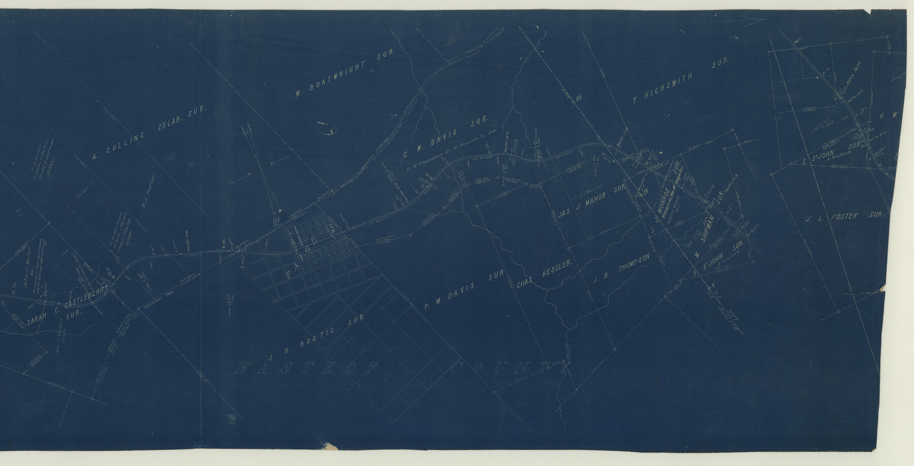
Houston & Texas Central Railway Through Bastrop County
Z-2-108
-
Map/Doc
64419
-
Collection
General Map Collection
-
Object Dates
1916 (Creation Date)
-
Counties
Bastrop Lee
-
Subjects
Railroads
-
Height x Width
21.3 x 41.6 inches
54.1 x 105.7 cm
-
Medium
blueprint/diazo
-
Scale
1"=1000 ft.
-
Comments
Segment 1; see counter no. 64419 for segment 2 and counter no. 64420 for label on reverse side of map.
-
Features
H&TC
San Antonio Road
Paige
Pin Oak Creek
Part of: General Map Collection
[Right of Way Map, Belton Branch of the M.K.&T. RR.]
![64221, [Right of Way Map, Belton Branch of the M.K.&T. RR.], General Map Collection](https://historictexasmaps.com/wmedia_w700/maps/64221.tif.jpg)
Print $20.00
- Digital $50.00
[Right of Way Map, Belton Branch of the M.K.&T. RR.]
1896
Size 22.0 x 7.1 inches
Map/Doc 64221
Coke County Rolled Sketch 3

Print $20.00
- Digital $50.00
Coke County Rolled Sketch 3
1947
Size 40.6 x 40.3 inches
Map/Doc 8623
Leon County Working Sketch 23

Print $20.00
- Digital $50.00
Leon County Working Sketch 23
1965
Size 14.2 x 29.7 inches
Map/Doc 70422
Map of Hamilton County

Print $20.00
- Digital $50.00
Map of Hamilton County
1872
Size 14.6 x 21.7 inches
Map/Doc 3620
Hansford County Working Sketch 9

Print $20.00
- Digital $50.00
Hansford County Working Sketch 9
1984
Size 31.5 x 38.2 inches
Map/Doc 63381
Coryell County Boundary File 1b

Print $68.00
- Digital $50.00
Coryell County Boundary File 1b
Size 18.1 x 16.1 inches
Map/Doc 51894
Presidio de San Antonio de Bejar

Presidio de San Antonio de Bejar
2006
Size 10.8 x 16.9 inches
Map/Doc 87385
Map of Cameron County

Print $20.00
- Digital $50.00
Map of Cameron County
1873
Size 42.9 x 24.3 inches
Map/Doc 66744
Real County Working Sketch 59

Print $20.00
- Digital $50.00
Real County Working Sketch 59
1962
Size 27.4 x 40.7 inches
Map/Doc 71951

Shelby County Working Sketch 24

Print $20.00
- Digital $50.00
Shelby County Working Sketch 24
1985
Size 38.3 x 39.0 inches
Map/Doc 63878
Montague County Working Sketch 30

Print $20.00
- Digital $50.00
Montague County Working Sketch 30
1974
Size 22.7 x 23.3 inches
Map/Doc 71096
You may also like
[East Half of Hutchinson County South of the Canadian River]
![91180, [East Half of Hutchinson County South of the Canadian River], Twichell Survey Records](https://historictexasmaps.com/wmedia_w700/maps/91180-1.tif.jpg)
Print $20.00
- Digital $50.00
[East Half of Hutchinson County South of the Canadian River]
Size 18.1 x 15.7 inches
Map/Doc 91180
Kent County Rolled Sketch 4

Print $20.00
- Digital $50.00
Kent County Rolled Sketch 4
1950
Size 22.1 x 31.1 inches
Map/Doc 6475
Hale County Rolled Sketch 6

Print $20.00
- Digital $50.00
Hale County Rolled Sketch 6
1903
Size 35.0 x 28.9 inches
Map/Doc 6045
Foard County Sketch File 30

Print $6.00
- Digital $50.00
Foard County Sketch File 30
Size 9.1 x 8.2 inches
Map/Doc 22858
Collingsworth County Working Sketch 2

Print $20.00
- Digital $50.00
Collingsworth County Working Sketch 2
1957
Size 10.2 x 32.6 inches
Map/Doc 63762
Schleicher County Sketch File 30

Print $4.00
- Digital $50.00
Schleicher County Sketch File 30
1940
Size 11.3 x 8.8 inches
Map/Doc 36528
Webb County Working Sketch 81

Print $40.00
- Digital $50.00
Webb County Working Sketch 81
1979
Size 69.0 x 43.6 inches
Map/Doc 72448
New Mexico and Adjacent Lands

New Mexico and Adjacent Lands
2022
Size 8.5 x 11.0 inches
Map/Doc 96977
Smith County Sketch File 4

Print $4.00
- Digital $50.00
Smith County Sketch File 4
1853
Size 10.3 x 8.1 inches
Map/Doc 36752
East Part of Brewster Co.

Print $40.00
- Digital $50.00
East Part of Brewster Co.
1952
Size 48.5 x 30.7 inches
Map/Doc 73087
Collin County Sketch File 3
Print $20.00
- Digital $50.00
Collin County Sketch File 3
1852
Size 19.5 x 21.4 inches
Map/Doc 11126
Map of Tascosa, Oldham County, Texas

Print $40.00
- Digital $50.00
Map of Tascosa, Oldham County, Texas
Size 34.8 x 66.8 inches
Map/Doc 89711