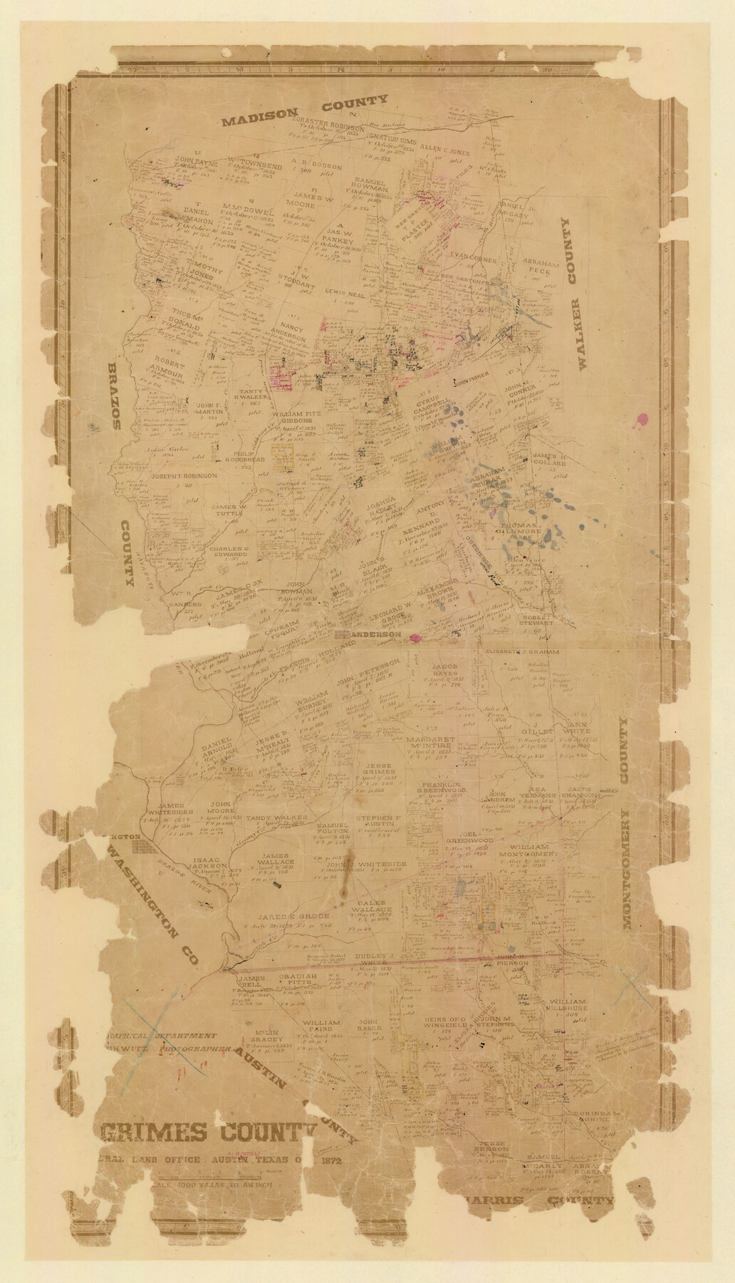
Grimes County
-
Map/Doc
4693
-
Collection
General Map Collection
-
Object Dates
10/1872 (Creation Date)
-
People and Organizations
Texas General Land Office (Publisher)
Herman Lungkwitz (Draftsman)
-
Counties
Grimes
-
Subjects
County
-
Height x Width
29.2 x 16.1 inches
74.2 x 40.9 cm
-
Scale
1" = 4000 varas
-
Comments
Early large-scale photos done in the General Land Office before lithographs or blueprints were used by the Land Office.
Conservation funded in 2012 by the Anderson-Shiro Junior/Senior High School Junior Historians, Anderson, Texas. -
Features
Spring Creek
Dry Creek
Lake Creek
Smith Creek
Big Bidais [Creek]
South Bidais Creek
San Jacinto Creek
San Jacinto River
Garrett's Creek
Indian Creek
Cedar Creek
Hurican [sic] Creek
Birch Creek
Walnut Creek
Brushy Creek
Pond Creek
Rio Bidais
Beason's Creek
Stephens Creek
Washington
Grassy Creek
Brazos River
Navasota River
Anderson
Hollands Creek
Rock Creek
Kinnard Road
Ben Fort Creek
Peach Creek
Walker Creek
Gibbons Creek
La Bahia Road
Part of: General Map Collection
Hudspeth County Working Sketch 51

Print $20.00
- Digital $50.00
Hudspeth County Working Sketch 51
Size 32.8 x 24.5 inches
Map/Doc 66336
Fort Bend County Sketch File 15

Print $5.00
- Digital $50.00
Fort Bend County Sketch File 15
Size 11.9 x 12.8 inches
Map/Doc 22925
Denton County

Print $20.00
- Digital $50.00
Denton County
1947
Size 42.5 x 39.7 inches
Map/Doc 73130
Hall County Working Sketch 9

Print $20.00
- Digital $50.00
Hall County Working Sketch 9
1972
Size 36.9 x 39.4 inches
Map/Doc 63337
Childress County Rolled Sketch 11

Print $20.00
- Digital $50.00
Childress County Rolled Sketch 11
1940
Size 45.3 x 12.0 inches
Map/Doc 8602
Childress County

Print $20.00
- Digital $50.00
Childress County
1892
Size 24.7 x 19.6 inches
Map/Doc 3391
Colorado County Sketch File 11

Print $6.00
- Digital $50.00
Colorado County Sketch File 11
Size 12.7 x 11.0 inches
Map/Doc 18935
Flight Mission No. DQN-1K, Frame 118, Calhoun County

Print $20.00
- Digital $50.00
Flight Mission No. DQN-1K, Frame 118, Calhoun County
1953
Size 18.5 x 22.2 inches
Map/Doc 84184
Newton County Sketch File 19

Print $20.00
- Digital $50.00
Newton County Sketch File 19
Size 22.8 x 9.4 inches
Map/Doc 42158
Map of Hidalgo County

Print $20.00
- Digital $50.00
Map of Hidalgo County
1896
Size 44.7 x 26.7 inches
Map/Doc 4978
McLennan County Sketch File 13a

Print $6.00
- Digital $50.00
McLennan County Sketch File 13a
Size 8.1 x 7.8 inches
Map/Doc 31269
Padre Island National Seashore

Print $4.00
- Digital $50.00
Padre Island National Seashore
Size 16.0 x 21.9 inches
Map/Doc 60526
You may also like
Menard County Boundary File 9

Print $4.00
- Digital $50.00
Menard County Boundary File 9
Size 9.9 x 8.1 inches
Map/Doc 57094
Orange County Working Sketch 11

Print $20.00
- Digital $50.00
Orange County Working Sketch 11
1922
Size 11.9 x 14.7 inches
Map/Doc 71343
Culberson County Rolled Sketch 51

Print $20.00
- Digital $50.00
Culberson County Rolled Sketch 51
1966
Size 35.2 x 27.0 inches
Map/Doc 5670
Maverick County Rolled Sketch 17

Print $20.00
- Digital $50.00
Maverick County Rolled Sketch 17
1910
Size 20.2 x 31.7 inches
Map/Doc 6710
Flight Mission No. DCL-7C, Frame 48, Kenedy County

Print $20.00
- Digital $50.00
Flight Mission No. DCL-7C, Frame 48, Kenedy County
1943
Size 16.6 x 16.5 inches
Map/Doc 86036
Map of the Houston & Great Northern Railroad

Print $40.00
- Digital $50.00
Map of the Houston & Great Northern Railroad
1871
Size 26.6 x 48.4 inches
Map/Doc 64472

North Sulphur River, Sims Crossing Sheet

Print $20.00
- Digital $50.00
North Sulphur River, Sims Crossing Sheet
1924
Size 23.4 x 39.9 inches
Map/Doc 65167
Dallam County

Print $40.00
- Digital $50.00
Dallam County
1926
Size 40.1 x 48.6 inches
Map/Doc 73125
Goliad County

Print $20.00
- Digital $50.00
Goliad County
1946
Size 44.0 x 46.1 inches
Map/Doc 95509
Flight Mission No. CGI-3N, Frame 103, Cameron County

Print $20.00
- Digital $50.00
Flight Mission No. CGI-3N, Frame 103, Cameron County
1954
Size 18.4 x 22.2 inches
Map/Doc 84583
Oldham County Working Sketch 2

Print $20.00
- Digital $50.00
Oldham County Working Sketch 2
1906
Size 16.1 x 15.1 inches
Map/Doc 71324