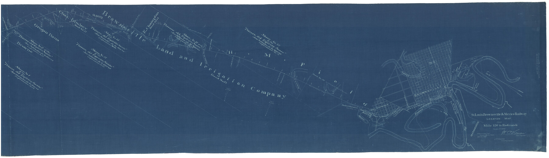
St. Louis, Brownsville & Mexico Railway Location Map from Mile 120 to Rio Grande
Z-2-47
-
Map/Doc
64170
-
Collection
General Map Collection
-
Object Dates
10/20/1905 (Creation Date)
-
People and Organizations
W.O. Homan (Surveyor/Engineer)
J.F. Hinckley (Surveyor/Engineer)
-
Counties
Cameron
-
Subjects
Railroads
-
Height x Width
19.6 x 67.7 inches
49.8 x 172.0 cm
-
Medium
blueprint/diazo
-
Scale
1" = 1000'
-
Comments
See counters 64165 through 64170 for all sheets.
-
Features
Resaca de Rancho Viejo
San Pedro Ranch
Topaqueje Ranch
San Pedro and Olmito Road
Olmito
Brownsville Road
Alice and Brownsville Road
Puente de Los Negros
Resaca de la Guerra
Brownsville
Rio Grande
Matamoros
Old Fort Brown
Fort Brown
Part of: General Map Collection
Flight Mission No. DCL-7C, Frame 58, Kenedy County

Print $20.00
- Digital $50.00
Flight Mission No. DCL-7C, Frame 58, Kenedy County
1943
Size 15.3 x 15.1 inches
Map/Doc 86046
Duval County Rolled Sketch OS

Print $20.00
- Digital $50.00
Duval County Rolled Sketch OS
1903
Size 36.0 x 31.9 inches
Map/Doc 8803
Montague County Working Sketch 29

Print $20.00
- Digital $50.00
Montague County Working Sketch 29
1972
Size 27.8 x 22.1 inches
Map/Doc 71095
Chambers County Rolled Sketch CL

Print $40.00
- Digital $50.00
Chambers County Rolled Sketch CL
1909
Size 56.2 x 21.0 inches
Map/Doc 8610
Hidalgo County Working Sketch 4

Print $20.00
- Digital $50.00
Hidalgo County Working Sketch 4
1938
Size 43.1 x 39.6 inches
Map/Doc 66181
Chambers County Rolled Sketch 32

Print $20.00
- Digital $50.00
Chambers County Rolled Sketch 32
1951
Size 26.7 x 37.8 inches
Map/Doc 5432
Pecos County Working Sketch 70

Print $20.00
- Digital $50.00
Pecos County Working Sketch 70
1957
Size 31.4 x 27.0 inches
Map/Doc 71542
Bastrop County Working Sketch 9

Print $20.00
- Digital $50.00
Bastrop County Working Sketch 9
1981
Size 44.9 x 43.7 inches
Map/Doc 67309
Flight Mission No. CGI-1N, Frame 180, Cameron County

Print $20.00
- Digital $50.00
Flight Mission No. CGI-1N, Frame 180, Cameron County
1955
Size 18.5 x 22.2 inches
Map/Doc 84515
Flight Mission No. CRC-4R, Frame 71, Chambers County

Print $20.00
- Digital $50.00
Flight Mission No. CRC-4R, Frame 71, Chambers County
1956
Size 18.7 x 22.5 inches
Map/Doc 84875
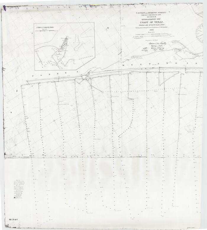
Corpus Christi Pass
Print $20.00
- Digital $50.00
Corpus Christi Pass
1880
Size 45.5 x 41.0 inches
Map/Doc 2694
Dickens County Sketch File 37

Print $8.00
- Digital $50.00
Dickens County Sketch File 37
Size 10.3 x 8.3 inches
Map/Doc 21044
You may also like
Parkland Place

Print $20.00
- Digital $50.00
Parkland Place
1928
Size 15.9 x 13.0 inches
Map/Doc 92278
Map of the Texas & Pacific Railway Company Reserve west of the Colorado River

Print $40.00
- Digital $50.00
Map of the Texas & Pacific Railway Company Reserve west of the Colorado River
1877
Size 48.9 x 59.2 inches
Map/Doc 2233
[Surveys along Bray's Bayou]
![157, [Surveys along Bray's Bayou], General Map Collection](https://historictexasmaps.com/wmedia_w700/maps/157.tif.jpg)
Print $2.00
- Digital $50.00
[Surveys along Bray's Bayou]
Size 7.6 x 4.9 inches
Map/Doc 157
Aransas County Sketch File 12

Print $8.00
- Digital $50.00
Aransas County Sketch File 12
Size 14.0 x 8.7 inches
Map/Doc 13118
Presidio County Rolled Sketch 33

Print $40.00
- Digital $50.00
Presidio County Rolled Sketch 33
Size 57.7 x 42.3 inches
Map/Doc 9772
Dawson County Rolled Sketch 13

Print $20.00
- Digital $50.00
Dawson County Rolled Sketch 13
1951
Size 18.9 x 25.4 inches
Map/Doc 5696
Duval County Boundary File 3e

Print $4.00
- Digital $50.00
Duval County Boundary File 3e
Size 10.0 x 7.9 inches
Map/Doc 52742
Angelina County

Print $40.00
- Digital $50.00
Angelina County
1899
Size 38.9 x 49.9 inches
Map/Doc 4873

[Sketch showing School Lands]
![90449, [Sketch showing School Lands], Twichell Survey Records](https://historictexasmaps.com/wmedia_w700/maps/90449-1.tif.jpg)
Print $20.00
- Digital $50.00
[Sketch showing School Lands]
Size 25.4 x 12.5 inches
Map/Doc 90449
Plan of the Battle of Buena-Vista fought February 22nd and 23rd, 1847

Print $20.00
- Digital $50.00
Plan of the Battle of Buena-Vista fought February 22nd and 23rd, 1847
1847
Size 17.6 x 21.6 inches
Map/Doc 95829
Robertson County Working Sketch 11

Print $20.00
- Digital $50.00
Robertson County Working Sketch 11
1984
Size 20.2 x 21.4 inches
Map/Doc 63584