Marion County Rolled Sketch 2
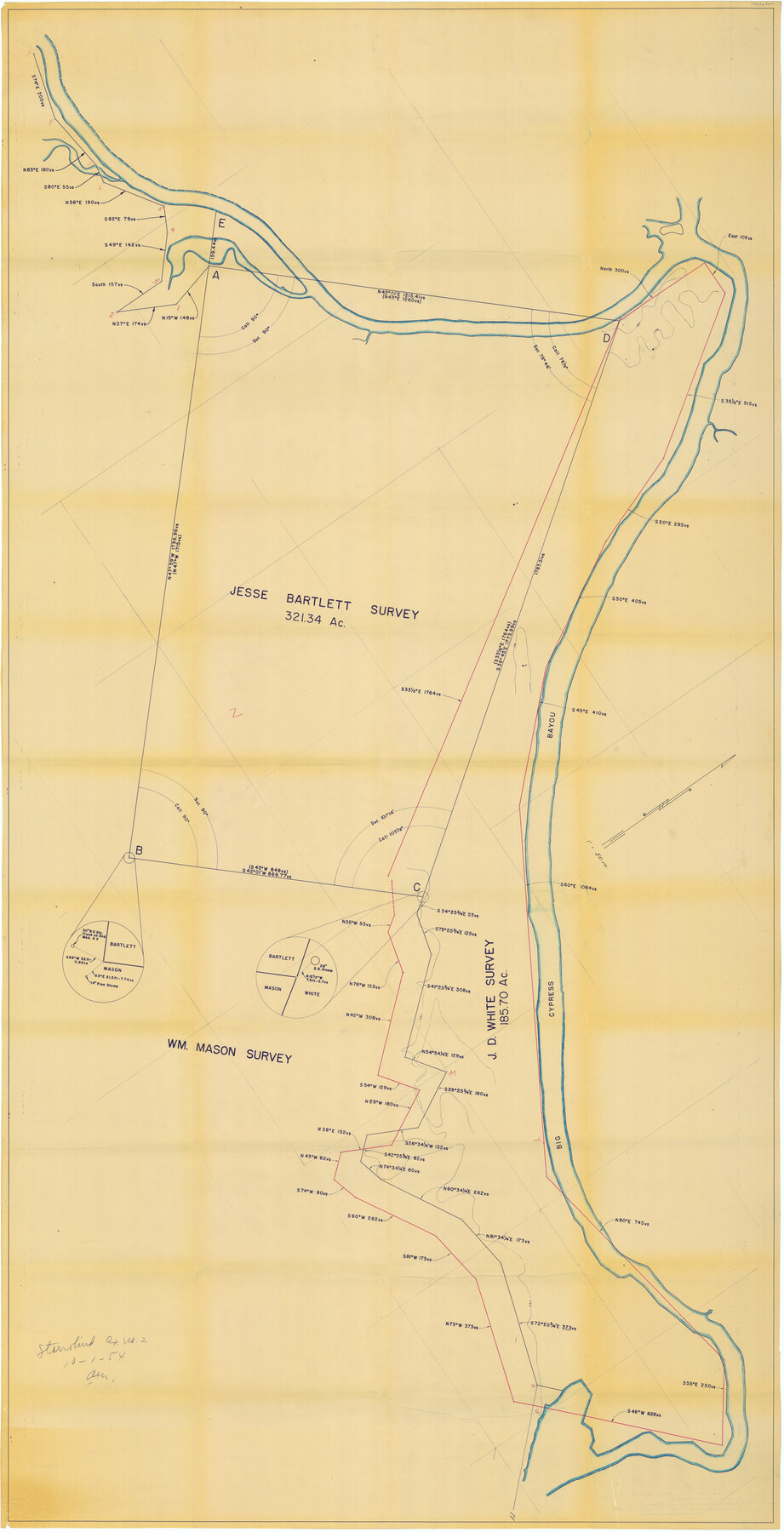
[Plat showing J.D. White and Jesse Bartlett surveys along Big Cypress Bayou regarding MA-46972]
-
Map/Doc
63912
-
Collection
General Map Collection
-
Object Dates
1954/10/1 (Creation Date)
-
Counties
Marion
-
Subjects
Surveying Rolled Sketch
-
Height x Width
89.3 x 45.7 inches
226.8 x 116.1 cm
-
Medium
van dyke/brownline/sepia
-
Scale
1" = 50 varas
-
Comments
See 46621 and 76446 for other sheets that make up this Rolled Sketch.
Related maps
Marion County Rolled Sketch 2

Print $20.00
- Digital $50.00
Marion County Rolled Sketch 2
1954
Size 34.8 x 45.9 inches
Map/Doc 46621
Marion County Rolled Sketch 2

Print $40.00
- Digital $50.00
Marion County Rolled Sketch 2
1954
Size 82.7 x 43.2 inches
Map/Doc 76446
Part of: General Map Collection
Topographical Map of the Rio Grande, Sheet No. 26

Print $20.00
- Digital $50.00
Topographical Map of the Rio Grande, Sheet No. 26
1912
Map/Doc 89550
Nueces County

Print $20.00
- Digital $50.00
Nueces County
1913
Size 23.5 x 32.3 inches
Map/Doc 77385
Flight Mission No. BRE-2P, Frame 135, Nueces County

Print $20.00
- Digital $50.00
Flight Mission No. BRE-2P, Frame 135, Nueces County
1956
Size 18.5 x 22.7 inches
Map/Doc 86808
Scurry County

Print $20.00
- Digital $50.00
Scurry County
1921
Size 42.4 x 39.1 inches
Map/Doc 95637
[Sketch for Mineral Application 12206 - Cow Bayou, O. B. Sawyer]
![65567, [Sketch for Mineral Application 12206 - Cow Bayou, O. B. Sawyer], General Map Collection](https://historictexasmaps.com/wmedia_w700/maps/65567.tif.jpg)
Print $40.00
- Digital $50.00
[Sketch for Mineral Application 12206 - Cow Bayou, O. B. Sawyer]
Size 140.6 x 37.5 inches
Map/Doc 65567
E. N. Gustafson's survey of Northern Portion of Lake Austin, Matagorda Co., TX

Print $40.00
- Digital $50.00
E. N. Gustafson's survey of Northern Portion of Lake Austin, Matagorda Co., TX
1926
Size 43.0 x 52.5 inches
Map/Doc 2068
Map of Taylor, Bastrop & Houston Railroad in Austin County

Print $20.00
- Digital $50.00
Map of Taylor, Bastrop & Houston Railroad in Austin County
Size 14.6 x 25.1 inches
Map/Doc 64480
Reagan County Working Sketch 8

Print $20.00
- Digital $50.00
Reagan County Working Sketch 8
1939
Size 37.8 x 23.3 inches
Map/Doc 71848
Burleson County Working Sketch 18

Print $20.00
- Digital $50.00
Burleson County Working Sketch 18
1980
Size 17.6 x 7.8 inches
Map/Doc 67737
Brewster County Sketch File N-25

Print $28.00
- Digital $50.00
Brewster County Sketch File N-25
1952
Size 24.4 x 9.1 inches
Map/Doc 15700
Flight Mission No. CUG-3P, Frame 164, Kleberg County

Print $20.00
- Digital $50.00
Flight Mission No. CUG-3P, Frame 164, Kleberg County
1956
Size 18.5 x 22.2 inches
Map/Doc 86284
Williamson County Sketch File 19

Print $24.00
- Digital $50.00
Williamson County Sketch File 19
Size 12.8 x 8.0 inches
Map/Doc 40345
You may also like
[Sketch Number 1, Block LC2 and Adjacent Leagues]
![91476, [Sketch Number 1, Block LC2 and Adjacent Leagues], Twichell Survey Records](https://historictexasmaps.com/wmedia_w700/maps/91476-1.tif.jpg)
Print $20.00
- Digital $50.00
[Sketch Number 1, Block LC2 and Adjacent Leagues]
Size 25.6 x 40.8 inches
Map/Doc 91476
Montgomery County Sketch File 36

Print $40.00
- Digital $50.00
Montgomery County Sketch File 36
1953
Size 51.7 x 34.9 inches
Map/Doc 10551
[Sketch for Mineral Application 26543 - Sabine River, D. H. Sanford]
![65677, [Sketch for Mineral Application 26543 - Sabine River, D. H. Sanford], General Map Collection](https://historictexasmaps.com/wmedia_w700/maps/65677.tif.jpg)
Print $40.00
- Digital $50.00
[Sketch for Mineral Application 26543 - Sabine River, D. H. Sanford]
1931
Size 30.8 x 71.9 inches
Map/Doc 65677
Harris County Rolled Sketch GC

Print $40.00
- Digital $50.00
Harris County Rolled Sketch GC
1917
Size 42.1 x 52.4 inches
Map/Doc 9115

Navigation Maps of Gulf Intracoastal Waterway, Port Arthur to Brownsville, Texas

Print $4.00
- Digital $50.00
Navigation Maps of Gulf Intracoastal Waterway, Port Arthur to Brownsville, Texas
1951
Size 16.6 x 21.2 inches
Map/Doc 65445
Cass County Working Sketch 6

Print $20.00
- Digital $50.00
Cass County Working Sketch 6
1936
Size 19.7 x 23.0 inches
Map/Doc 67909
Trinity County Sketch File 22

Print $23.00
- Digital $50.00
Trinity County Sketch File 22
1877
Size 9.4 x 12.3 inches
Map/Doc 38550
[Block 3 Sections 322, 321, 319, Block 1 Section 1]
![92938, [Block 3 Sections 322, 321, 319, Block 1 Section 1], Twichell Survey Records](https://historictexasmaps.com/wmedia_w700/maps/92938-1.tif.jpg)
Print $20.00
- Digital $50.00
[Block 3 Sections 322, 321, 319, Block 1 Section 1]
Size 21.1 x 20.4 inches
Map/Doc 92938
Flight Mission No. BQR-9K, Frame 9, Brazoria County

Print $20.00
- Digital $50.00
Flight Mission No. BQR-9K, Frame 9, Brazoria County
1952
Size 18.6 x 22.3 inches
Map/Doc 84038
Burnet County Rolled Sketch 2

Print $20.00
- Digital $50.00
Burnet County Rolled Sketch 2
1948
Size 15.5 x 30.5 inches
Map/Doc 5354
Gulf Oil Corp. Fishgide - Freeport

Gulf Oil Corp. Fishgide - Freeport
1960
Size 12.1 x 22.1 inches
Map/Doc 75979