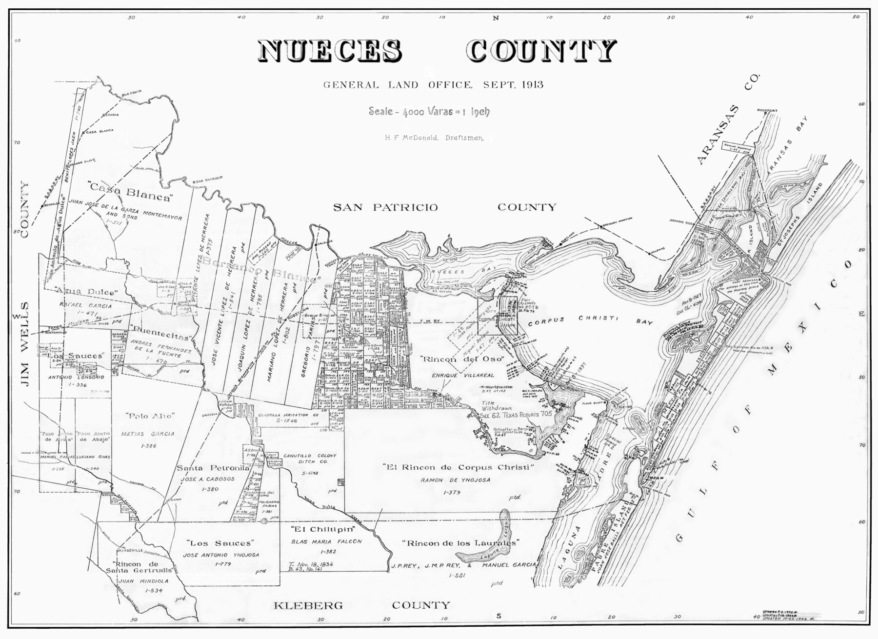
Nueces County
-
Map/Doc
77385
-
Collection
General Map Collection
-
Object Dates
1913 (Creation Date)
-
People and Organizations
H.F. McDonald (Draftsman)
-
Counties
Nueces
-
Subjects
County
-
Height x Width
23.5 x 32.3 inches
59.7 x 82.0 cm
Part of: General Map Collection
Hays County Sketch File 13 and 14

Print $8.00
- Digital $50.00
Hays County Sketch File 13 and 14
1868
Size 12.4 x 8.0 inches
Map/Doc 26220
Swisher County Rolled Sketch 5

Print $20.00
- Digital $50.00
Swisher County Rolled Sketch 5
1904
Size 18.1 x 19.4 inches
Map/Doc 7906
Current Miscellaneous File 85

Print $10.00
- Digital $50.00
Current Miscellaneous File 85
Size 11.3 x 8.8 inches
Map/Doc 74235
Reeves County Working Sketch 11

Print $20.00
- Digital $50.00
Reeves County Working Sketch 11
1957
Size 27.7 x 36.9 inches
Map/Doc 63454
Reeves County Working Sketch 17

Print $20.00
- Digital $50.00
Reeves County Working Sketch 17
1961
Size 30.2 x 30.9 inches
Map/Doc 63460
Hudspeth County Working Sketch 61

Print $20.00
- Digital $50.00
Hudspeth County Working Sketch 61
1992
Size 42.8 x 31.2 inches
Map/Doc 66346
Sabine River, Gladewater Sheet

Print $20.00
- Digital $50.00
Sabine River, Gladewater Sheet
1933
Size 38.5 x 30.9 inches
Map/Doc 65138
Fisher County Working Sketch 16

Print $20.00
- Digital $50.00
Fisher County Working Sketch 16
1958
Size 34.6 x 37.4 inches
Map/Doc 69150
Guadalupe County Sketch File 3

Print $4.00
- Digital $50.00
Guadalupe County Sketch File 3
Size 8.0 x 12.6 inches
Map/Doc 24650
Castro County Sketch File 4f

Print $4.00
- Digital $50.00
Castro County Sketch File 4f
Size 13.8 x 8.9 inches
Map/Doc 17475
Edwards County

Print $20.00
- Digital $50.00
Edwards County
1883
Size 28.2 x 17.9 inches
Map/Doc 3505
Map of Washington County

Print $20.00
- Digital $50.00
Map of Washington County
1841
Size 18.9 x 27.1 inches
Map/Doc 4126
You may also like

Borden County

Print $20.00
- Digital $50.00
Borden County
1922
Size 37.2 x 41.6 inches
Map/Doc 92456
McMullen County Sketch File 45

Print $10.00
- Digital $50.00
McMullen County Sketch File 45
1943
Size 14.2 x 8.9 inches
Map/Doc 31429
Crockett County Working Sketch 7

Print $20.00
- Digital $50.00
Crockett County Working Sketch 7
1891
Size 18.4 x 21.7 inches
Map/Doc 68340
Irion County Sketch File 1

Print $20.00
- Digital $50.00
Irion County Sketch File 1
1881
Size 43.9 x 18.3 inches
Map/Doc 10615
Pecos County Boundary File 1b

Print $8.00
- Digital $50.00
Pecos County Boundary File 1b
Size 14.2 x 8.5 inches
Map/Doc 57861
Reeves County Sketch File 21

Print $20.00
- Digital $50.00
Reeves County Sketch File 21
Size 21.9 x 21.7 inches
Map/Doc 12246
Map of Aransas Co.

Print $20.00
- Digital $50.00
Map of Aransas Co.
1896
Size 38.8 x 36.8 inches
Map/Doc 4874
Brazoria County NRC Article 33.136 Sketch 18

Print $24.00
- Digital $50.00
Brazoria County NRC Article 33.136 Sketch 18
2015
Size 24.0 x 36.0 inches
Map/Doc 95066
Zapata County Sketch File 10

Print $40.00
- Digital $50.00
Zapata County Sketch File 10
1917
Size 51.0 x 32.6 inches
Map/Doc 10440
Hood County Working Sketch 29

Print $20.00
- Digital $50.00
Hood County Working Sketch 29
1934
Size 21.5 x 25.0 inches
Map/Doc 66223
Hemphill County Rolled Sketch 17

Print $20.00
- Digital $50.00
Hemphill County Rolled Sketch 17
1965
Size 29.2 x 40.1 inches
Map/Doc 6198