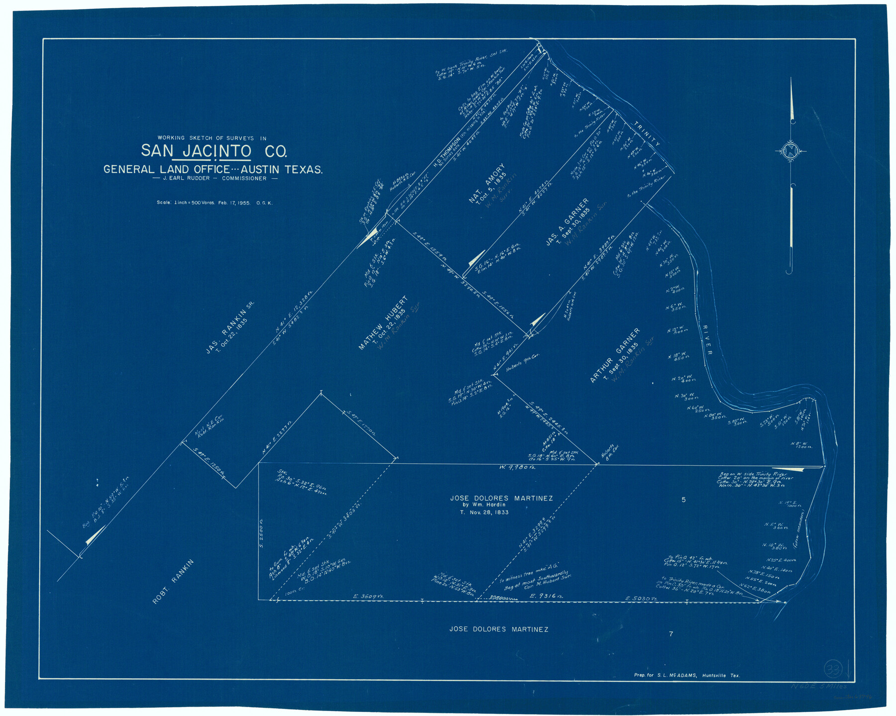
San Jacinto County Working Sketch 33
-
Map/Doc
63746
-
Collection
General Map Collection
-
Object Dates
2/17/1955 (Creation Date)
-
People and Organizations
Otto G. Kurio (Draftsman)
-
Counties
San Jacinto
-
Subjects
Surveying Working Sketch
-
Height x Width
25.4 x 31.8 inches
64.5 x 80.8 cm
-
Scale
1" = 500 varas
Part of: General Map Collection
Motley County Sketch File 37 (S)

Print $22.00
- Digital $50.00
Motley County Sketch File 37 (S)
Size 11.3 x 8.7 inches
Map/Doc 32222
Harris County Sketch File 1

Print $20.00
- Digital $50.00
Harris County Sketch File 1
Size 14.8 x 12.6 inches
Map/Doc 25332
Donley County Sketch File 5

Print $14.00
- Digital $50.00
Donley County Sketch File 5
Size 12.9 x 8.5 inches
Map/Doc 21223
Webb County Sketch File 10-2

Print $10.00
- Digital $50.00
Webb County Sketch File 10-2
1933
Size 16.9 x 10.9 inches
Map/Doc 39766
Mexico or New Spain in which the Motions of Cortes may be traced

Print $20.00
- Digital $50.00
Mexico or New Spain in which the Motions of Cortes may be traced
1795
Size 14.5 x 16.5 inches
Map/Doc 93650
Cherokee County Working Sketch 8

Print $20.00
- Digital $50.00
Cherokee County Working Sketch 8
1956
Size 22.0 x 45.2 inches
Map/Doc 67963
Culberson County Rolled Sketch 19

Print $20.00
- Digital $50.00
Culberson County Rolled Sketch 19
Size 18.8 x 29.4 inches
Map/Doc 5651
Leon County Rolled Sketch 18

Print $20.00
- Digital $50.00
Leon County Rolled Sketch 18
1982
Size 33.1 x 34.8 inches
Map/Doc 6604
Flight Mission No. BRE-1P, Frame 138, Nueces County

Print $20.00
- Digital $50.00
Flight Mission No. BRE-1P, Frame 138, Nueces County
1956
Size 18.4 x 22.3 inches
Map/Doc 86698
Runnels County Sketch File 30

Print $20.00
Runnels County Sketch File 30
1950
Size 18.8 x 19.6 inches
Map/Doc 12262
Brewster County Working Sketch 1

Print $20.00
- Digital $50.00
Brewster County Working Sketch 1
1904
Size 27.4 x 25.8 inches
Map/Doc 67534
Morris County Rolled Sketch 2A

Print $20.00
- Digital $50.00
Morris County Rolled Sketch 2A
Size 24.0 x 18.6 inches
Map/Doc 10235
You may also like
Freestone County Working Sketch 26

Print $20.00
- Digital $50.00
Freestone County Working Sketch 26
1907
Size 27.7 x 30.3 inches
Map/Doc 69268
Flight Mission No. CUG-1P, Frame 75, Kleberg County

Print $20.00
- Digital $50.00
Flight Mission No. CUG-1P, Frame 75, Kleberg County
1956
Size 18.5 x 22.3 inches
Map/Doc 86140
Somervell County Working Sketch 3

Print $20.00
- Digital $50.00
Somervell County Working Sketch 3
1968
Size 23.0 x 30.4 inches
Map/Doc 63907
Dallam County Boundary File 1

Print $12.00
- Digital $50.00
Dallam County Boundary File 1
Size 9.0 x 7.6 inches
Map/Doc 52047
Cherokee County Sketch File 11

Print $4.00
- Digital $50.00
Cherokee County Sketch File 11
1852
Size 11.5 x 8.2 inches
Map/Doc 18138
Hutchinson County Working Sketch 3

Print $20.00
- Digital $50.00
Hutchinson County Working Sketch 3
Size 18.2 x 15.8 inches
Map/Doc 66361
Preliminary Chart of the Sea Coast of Texas in the Vicinity of Galveston

Print $20.00
Preliminary Chart of the Sea Coast of Texas in the Vicinity of Galveston
1856
Size 26.3 x 19.7 inches
Map/Doc 76256
Moore County Sketch File 10

Print $20.00
- Digital $50.00
Moore County Sketch File 10
1910
Size 18.7 x 30.1 inches
Map/Doc 42128
Hudspeth County Rolled Sketch 47

Print $20.00
- Digital $50.00
Hudspeth County Rolled Sketch 47
1963
Size 22.2 x 25.9 inches
Map/Doc 6255
Genl. Austins Map of Texas With Parts of the Adjoining States

Print $20.00
- Digital $50.00
Genl. Austins Map of Texas With Parts of the Adjoining States
1840
Size 28.5 x 23.4 inches
Map/Doc 2116
Webb County Working Sketch 71

Print $40.00
- Digital $50.00
Webb County Working Sketch 71
1973
Size 46.1 x 95.8 inches
Map/Doc 72438
[H. & G. N. Block 1]
![90940, [H. & G. N. Block 1], Twichell Survey Records](https://historictexasmaps.com/wmedia_w700/maps/90940-1.tif.jpg)
Print $20.00
- Digital $50.00
[H. & G. N. Block 1]
1873
Size 17.3 x 14.2 inches
Map/Doc 90940