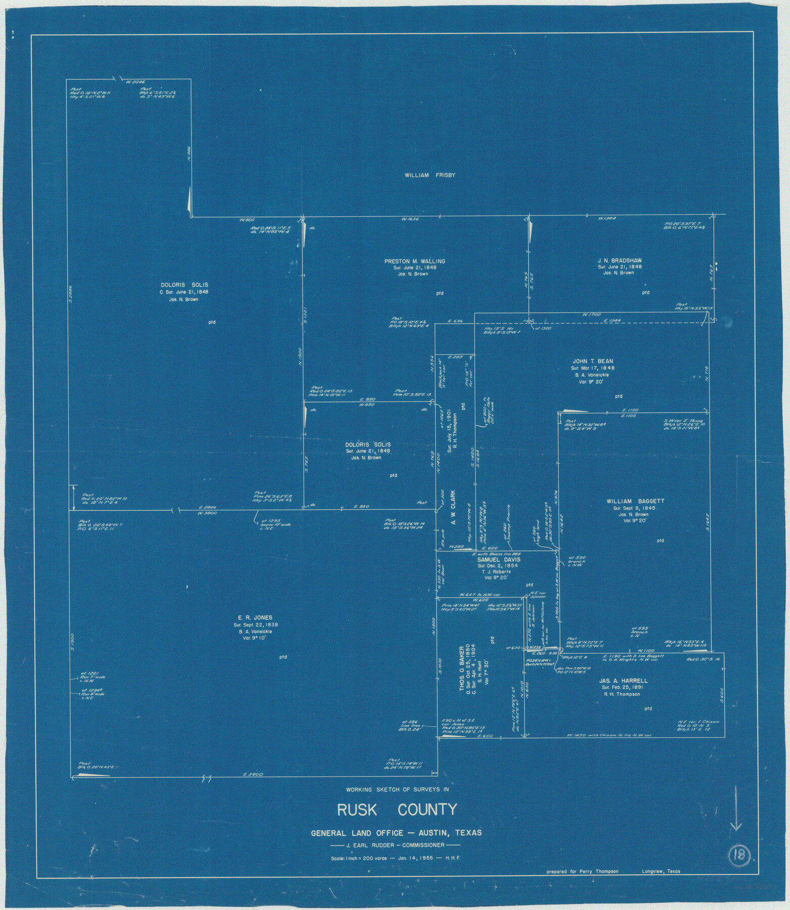
Rusk County Working Sketch 18
-
Map/Doc
63653
-
Collection
General Map Collection
-
Object Dates
1/14/1955 (Creation Date)
-
People and Organizations
Herman H. Forbes (Draftsman)
-
Counties
Rusk
-
Subjects
Surveying Working Sketch
-
Height x Width
32.6 x 28.3 inches
82.8 x 71.9 cm
-
Scale
1" = 200 varas
Part of: General Map Collection
Map of the State of Louisiana engraved for Mitchell's new intermediate geography, Louisiana Edition (Inset: Vicinity of New Orleans)

Print $20.00
- Digital $50.00
Map of the State of Louisiana engraved for Mitchell's new intermediate geography, Louisiana Edition (Inset: Vicinity of New Orleans)
1885
Size 9.0 x 12.2 inches
Map/Doc 93533
Cherokee County Sketch File 12b

Print $6.00
- Digital $50.00
Cherokee County Sketch File 12b
1850
Size 7.9 x 7.7 inches
Map/Doc 18142
Garza County Sketch File X

Print $22.00
- Digital $50.00
Garza County Sketch File X
Size 17.1 x 12.3 inches
Map/Doc 24042
Marion County Sketch File 10

Print $4.00
- Digital $50.00
Marion County Sketch File 10
1867
Size 7.9 x 12.4 inches
Map/Doc 30579
History Salvaged from the Sea

History Salvaged from the Sea
1977
Size 23.0 x 30.4 inches
Map/Doc 96836

Starr County Sketch File 37

Print $10.00
- Digital $50.00
Starr County Sketch File 37
1940
Size 2.7 x 8.8 inches
Map/Doc 36980
Hardin County Working Sketch 19

Print $20.00
- Digital $50.00
Hardin County Working Sketch 19
1947
Size 28.9 x 34.3 inches
Map/Doc 63417
Flight Mission No. DQO-2K, Frame 90, Galveston County

Print $20.00
- Digital $50.00
Flight Mission No. DQO-2K, Frame 90, Galveston County
1952
Size 18.8 x 22.6 inches
Map/Doc 85017
Controlled Mosaic by Jack Amman Photogrammetric Engineers, Inc - Sheet 40

Print $20.00
- Digital $50.00
Controlled Mosaic by Jack Amman Photogrammetric Engineers, Inc - Sheet 40
1954
Size 20.0 x 24.0 inches
Map/Doc 83495
Moore County Rolled Sketch 4

Print $20.00
- Digital $50.00
Moore County Rolled Sketch 4
Size 21.1 x 12.1 inches
Map/Doc 6824
Lavaca County Sketch File 23

Print $20.00
- Digital $50.00
Lavaca County Sketch File 23
1986
Size 14.0 x 8.6 inches
Map/Doc 29668
You may also like
Pecos County Working Sketch 142

Print $40.00
- Digital $50.00
Pecos County Working Sketch 142
2007
Size 38.0 x 63.4 inches
Map/Doc 88610
Flight Mission No. DQN-2K, Frame 139, Calhoun County

Print $20.00
- Digital $50.00
Flight Mission No. DQN-2K, Frame 139, Calhoun County
1953
Size 16.3 x 16.2 inches
Map/Doc 84308
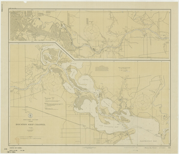
Houston Ship Channel
Print $20.00
- Digital $50.00
Houston Ship Channel
1926
Size 32.9 x 38.3 inches
Map/Doc 69893
Hidalgo County Sketch File 3

Print $40.00
- Digital $50.00
Hidalgo County Sketch File 3
1878
Size 14.1 x 13.1 inches
Map/Doc 26401
Fannin County Boundary File 10a and 10b and 10c

Print $4.00
- Digital $50.00
Fannin County Boundary File 10a and 10b and 10c
Size 11.3 x 8.8 inches
Map/Doc 53325
Jack County Sketch File 35

Print $20.00
- Digital $50.00
Jack County Sketch File 35
1958
Size 23.9 x 35.6 inches
Map/Doc 11833
Flight Mission No. BQR-3K, Frame 154, Brazoria County

Print $20.00
- Digital $50.00
Flight Mission No. BQR-3K, Frame 154, Brazoria County
1952
Size 18.7 x 22.3 inches
Map/Doc 83981
Milam County Working Sketch 7

Print $40.00
- Digital $50.00
Milam County Working Sketch 7
1969
Size 42.7 x 48.0 inches
Map/Doc 71022
T. C. Ivey Ranch Block D

Print $20.00
- Digital $50.00
T. C. Ivey Ranch Block D
Size 17.5 x 14.8 inches
Map/Doc 92846
[Surveys near the Medina River, Bexar District]
![230, [Surveys near the Medina River, Bexar District], General Map Collection](https://historictexasmaps.com/wmedia_w700/maps/230.tif.jpg)
Print $2.00
- Digital $50.00
[Surveys near the Medina River, Bexar District]
1847
Size 13.1 x 8.0 inches
Map/Doc 230
The Republic County of San Patricio. Proposed, Late Fall 1837

Print $20.00
The Republic County of San Patricio. Proposed, Late Fall 1837
2020
Size 17.8 x 21.7 inches
Map/Doc 96273
Bell County Sketch File 12a

Print $6.00
- Digital $50.00
Bell County Sketch File 12a
1853
Size 12.8 x 8.0 inches
Map/Doc 14387