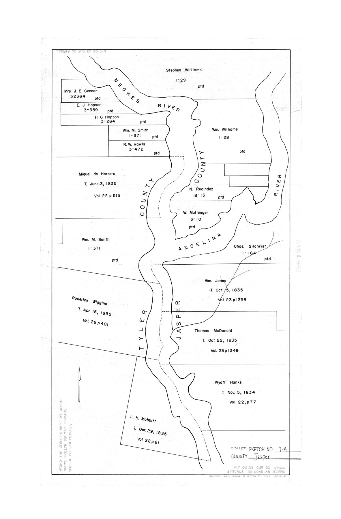
Jasper County Rolled Sketch 7A
[Office sketch showing surveys along the Neches & Angelina Rivers]
-
Map/Doc
6354
-
Collection
General Map Collection
-
Counties
Jasper Tyler
-
Subjects
Surveying Rolled Sketch
-
Height x Width
22.4 x 14.7 inches
56.9 x 37.3 cm
Part of: General Map Collection
Lynn County Rolled Sketch WR

Print $20.00
- Digital $50.00
Lynn County Rolled Sketch WR
Size 14.7 x 23.8 inches
Map/Doc 6656
Polk County Sketch File 45

Print $4.00
- Digital $50.00
Polk County Sketch File 45
Size 11.3 x 8.8 inches
Map/Doc 34376
Nueces County Sketch File 86

Print $2.00
- Digital $50.00
Nueces County Sketch File 86
Map/Doc 81935
Burnet County Sketch File 29

Print $4.00
- Digital $50.00
Burnet County Sketch File 29
1874
Size 10.1 x 8.1 inches
Map/Doc 16744
Newton County Sketch File 44

Print $8.00
- Digital $50.00
Newton County Sketch File 44
1945
Size 11.2 x 8.6 inches
Map/Doc 32441
Nueces County Rolled Sketch 86

Print $167.00
Nueces County Rolled Sketch 86
1983
Size 18.2 x 24.7 inches
Map/Doc 6978
Flight Mission No. CRC-2R, Frame 6, Chambers County

Print $20.00
- Digital $50.00
Flight Mission No. CRC-2R, Frame 6, Chambers County
1956
Size 18.8 x 22.5 inches
Map/Doc 84725
Flight Mission No. CGI-4N, Frame 171, Cameron County

Print $20.00
- Digital $50.00
Flight Mission No. CGI-4N, Frame 171, Cameron County
1955
Size 18.5 x 22.4 inches
Map/Doc 84674
Aransas County Working Sketch 16

Print $40.00
- Digital $50.00
Aransas County Working Sketch 16
1965
Size 55.3 x 43.1 inches
Map/Doc 67183
[Beaumont, Sour Lake and Western Ry. Right of Way and Alignment - Frisco]
![64128, [Beaumont, Sour Lake and Western Ry. Right of Way and Alignment - Frisco], General Map Collection](https://historictexasmaps.com/wmedia_w700/maps/64128.tif.jpg)
Print $20.00
- Digital $50.00
[Beaumont, Sour Lake and Western Ry. Right of Way and Alignment - Frisco]
1910
Size 20.1 x 45.9 inches
Map/Doc 64128
Maps of Gulf Intracoastal Waterway, Texas - Sabine River to the Rio Grande and connecting waterways including ship channels

Print $20.00
- Digital $50.00
Maps of Gulf Intracoastal Waterway, Texas - Sabine River to the Rio Grande and connecting waterways including ship channels
1966
Size 14.6 x 22.2 inches
Map/Doc 61952
Jim Hogg County Boundary File 2

Print $4.00
- Digital $50.00
Jim Hogg County Boundary File 2
Size 10.6 x 8.7 inches
Map/Doc 55527
You may also like
Johnson County Working Sketch 10

Print $20.00
- Digital $50.00
Johnson County Working Sketch 10
1953
Size 26.2 x 37.1 inches
Map/Doc 66623
Packery Channel

Print $20.00
- Digital $50.00
Packery Channel
1958
Size 29.5 x 37.5 inches
Map/Doc 2992

McMullen County Rolled Sketch 7

Print $40.00
- Digital $50.00
McMullen County Rolled Sketch 7
1939
Size 38.8 x 51.7 inches
Map/Doc 9500
Kent County Working Sketch 12

Print $20.00
- Digital $50.00
Kent County Working Sketch 12
1953
Size 33.8 x 24.3 inches
Map/Doc 70019
[Sketch of Blocks C2, C, D7, A, RG and San Augustine County School Land]
![93021, [Sketch of Blocks C2, C, D7, A, RG and San Augustine County School Land], Twichell Survey Records](https://historictexasmaps.com/wmedia_w700/maps/93021-1.tif.jpg)
Print $20.00
- Digital $50.00
[Sketch of Blocks C2, C, D7, A, RG and San Augustine County School Land]
Size 15.5 x 25.8 inches
Map/Doc 93021

Edwards County Sketch File 4

Print $5.00
- Digital $50.00
Edwards County Sketch File 4
Size 9.5 x 11.0 inches
Map/Doc 21680
Lampasas County Working Sketch 24

Print $20.00
- Digital $50.00
Lampasas County Working Sketch 24
Size 14.3 x 13.3 inches
Map/Doc 61796
Texas Panhandle East Boundary Line

Print $20.00
- Digital $50.00
Texas Panhandle East Boundary Line
1898
Size 11.6 x 35.5 inches
Map/Doc 1741
Flight Mission No. BRE-1P, Frame 70, Nueces County

Print $20.00
- Digital $50.00
Flight Mission No. BRE-1P, Frame 70, Nueces County
1956
Size 18.3 x 22.1 inches
Map/Doc 86652
Crockett County Working Sketch 55

Print $40.00
- Digital $50.00
Crockett County Working Sketch 55
1951
Size 51.0 x 37.5 inches
Map/Doc 68388