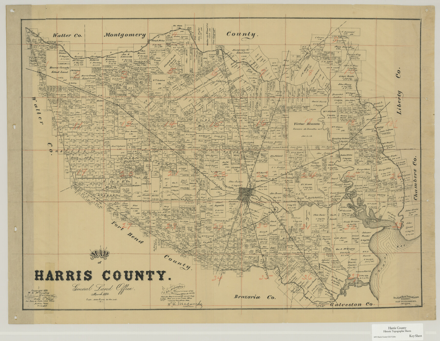
Map of Harris County
Harris County Historic Topographic Sheets: Key Sheet
-
Map/Doc
65810
-
Collection
General Map Collection
-
Object Dates
3/1893 (Creation Date)
-
People and Organizations
General Land Office (Publisher)
W.L. McGaughey (GLO Commissioner)
F.G. Blau (Draftsman)
August Gast Bank Note & Lithograph Company (Lithographer)
-
Counties
Harris
-
Subjects
Topographic
-
Height x Width
26.6 x 34.4 inches
67.6 x 87.4 cm
-
Scale
1" = 4000 varas
-
Comments
"Aug. Gast Bank Note & Litho. Company; Map Publishers, St. Louis"
Shows handwritten location of the Houston County Topographical Sheets by number.
Alternative title from label.
Part of: General Map Collection
Reeves County Working Sketch 36

Print $20.00
- Digital $50.00
Reeves County Working Sketch 36
1970
Size 43.1 x 35.0 inches
Map/Doc 63479
Glasscock County Working Sketch 4

Print $20.00
- Digital $50.00
Glasscock County Working Sketch 4
Size 15.7 x 25.9 inches
Map/Doc 63177
Rusk County Sketch File 33

Print $10.00
Rusk County Sketch File 33
1949
Size 11.5 x 8.8 inches
Map/Doc 35568
Milam County Boundary File 6c

Print $2.00
- Digital $50.00
Milam County Boundary File 6c
Size 11.2 x 8.5 inches
Map/Doc 57250
Orange County Working Sketch 12

Print $20.00
- Digital $50.00
Orange County Working Sketch 12
1922
Size 17.2 x 12.7 inches
Map/Doc 71344

El Paso County Working Sketch 24

Print $20.00
- Digital $50.00
El Paso County Working Sketch 24
1961
Size 26.4 x 22.0 inches
Map/Doc 69046
Kerr County Working Sketch 29

Print $20.00
- Digital $50.00
Kerr County Working Sketch 29
1972
Size 46.3 x 33.1 inches
Map/Doc 70060
Flight Mission No. BRE-1P, Frame 139, Nueces County

Print $20.00
- Digital $50.00
Flight Mission No. BRE-1P, Frame 139, Nueces County
1956
Size 18.8 x 22.6 inches
Map/Doc 86699
Brewster County Working Sketch 53

Print $20.00
- Digital $50.00
Brewster County Working Sketch 53
1951
Size 32.1 x 16.5 inches
Map/Doc 67587

Bee County Sketch File 16

Print $4.00
- Digital $50.00
Bee County Sketch File 16
1878
Size 8.6 x 7.7 inches
Map/Doc 14299
You may also like
Flight Mission No. DCL-7C, Frame 4, Kenedy County

Print $20.00
- Digital $50.00
Flight Mission No. DCL-7C, Frame 4, Kenedy County
1943
Size 18.6 x 22.3 inches
Map/Doc 85996
Shackelford County Sketch File 6

Print $20.00
- Digital $50.00
Shackelford County Sketch File 6
Size 14.8 x 24.5 inches
Map/Doc 81981
Wichita County Rolled Sketch 20

Print $45.00
- Digital $50.00
Wichita County Rolled Sketch 20
Size 11.0 x 14.5 inches
Map/Doc 49546
Travis County Sketch File 38

Print $20.00
- Digital $50.00
Travis County Sketch File 38
1913
Size 16.6 x 17.4 inches
Map/Doc 12462
Harris County Working Sketch 102

Print $20.00
- Digital $50.00
Harris County Working Sketch 102
1980
Size 33.6 x 18.9 inches
Map/Doc 65994
Aransas County NRC Article 33.136 Sketch 8

Print $22.00
- Digital $50.00
Aransas County NRC Article 33.136 Sketch 8
2007
Size 24.0 x 36.0 inches
Map/Doc 88800
Plat of Corpus Christi

Print $20.00
Plat of Corpus Christi
1850
Size 18.0 x 27.2 inches
Map/Doc 76269
Flight Mission No. DQO-3K, Frame 78, Galveston County

Print $20.00
- Digital $50.00
Flight Mission No. DQO-3K, Frame 78, Galveston County
1952
Size 18.8 x 22.6 inches
Map/Doc 85083
Liberty County Working Sketch 75

Print $20.00
- Digital $50.00
Liberty County Working Sketch 75
1980
Size 23.2 x 23.8 inches
Map/Doc 70535
McMullen County Working Sketch 32

Print $20.00
- Digital $50.00
McMullen County Working Sketch 32
1958
Size 28.2 x 32.5 inches
Map/Doc 70733
Starr County Rolled Sketch 40

Print $20.00
- Digital $50.00
Starr County Rolled Sketch 40
1961
Size 21.3 x 22.6 inches
Map/Doc 7834
Donley County Boundary File 8

Print $4.00
- Digital $50.00
Donley County Boundary File 8
Size 11.2 x 8.7 inches
Map/Doc 52655