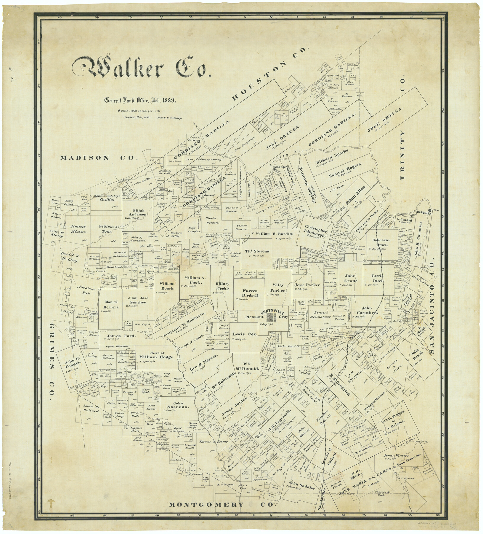
Walker Co.
-
Map/Doc
63105
-
Collection
General Map Collection
-
Object Dates
1889 (Creation Date)
-
People and Organizations
Texas General Land Office (Publisher)
-
Counties
Walker
-
Subjects
County
-
Height x Width
42.5 x 38.5 inches
108.0 x 97.8 cm
-
Comments
Copied in February 1903 by Frank R. Sweeney.
Part of: General Map Collection
The North Coast of the Gulf of Mexico from St. Marks to Galveston

Print $20.00
- Digital $50.00
The North Coast of the Gulf of Mexico from St. Marks to Galveston
1844
Size 27.5 x 41.1 inches
Map/Doc 97396
Anderson County Working Sketch 41

Print $20.00
- Digital $50.00
Anderson County Working Sketch 41
1956
Size 19.2 x 20.5 inches
Map/Doc 67041
Waller County Sketch File 9

Print $4.00
- Digital $50.00
Waller County Sketch File 9
Size 9.1 x 7.8 inches
Map/Doc 39610
Jeff Davis County Working Sketch 15

Print $20.00
- Digital $50.00
Jeff Davis County Working Sketch 15
1950
Size 34.6 x 29.0 inches
Map/Doc 66510
Flight Mission No. DIX-3P, Frame 136, Aransas County

Print $20.00
- Digital $50.00
Flight Mission No. DIX-3P, Frame 136, Aransas County
1956
Size 17.9 x 19.0 inches
Map/Doc 83766
Map of Nacogdoches County

Print $20.00
- Digital $50.00
Map of Nacogdoches County
1846
Size 42.7 x 40.0 inches
Map/Doc 87358
Matagorda County Sketch File 24

Print $10.00
- Digital $50.00
Matagorda County Sketch File 24
1900
Size 8.2 x 5.1 inches
Map/Doc 30787
Map showing survey for proposed ship channel from Brownsville to Brazos Santiago Pass

Print $20.00
- Digital $50.00
Map showing survey for proposed ship channel from Brownsville to Brazos Santiago Pass
1912
Size 18.1 x 28.7 inches
Map/Doc 72902
Flight Mission No. BRA-16M, Frame 181, Jefferson County

Print $20.00
- Digital $50.00
Flight Mission No. BRA-16M, Frame 181, Jefferson County
1953
Size 18.6 x 22.2 inches
Map/Doc 85779
Montague County Sketch File 27

Print $20.00
- Digital $50.00
Montague County Sketch File 27
1954
Size 15.8 x 22.5 inches
Map/Doc 12109
Palo Pinto County Working Sketch 27

Print $6.00
- Digital $50.00
Palo Pinto County Working Sketch 27
2006
Map/Doc 83609
Jeff Davis County Working Sketch 39

Print $40.00
- Digital $50.00
Jeff Davis County Working Sketch 39
1981
Size 52.1 x 38.0 inches
Map/Doc 66534
You may also like
[Map of Navarro County]
![81900, [Map of Navarro County], General Map Collection](https://historictexasmaps.com/wmedia_w700/maps/81900.tif.jpg)
Print $20.00
- Digital $50.00
[Map of Navarro County]
1858
Size 18.0 x 23.5 inches
Map/Doc 81900
Harris County Sketch File 3

Print $4.00
- Digital $50.00
Harris County Sketch File 3
Size 7.0 x 6.2 inches
Map/Doc 25334
Galveston County Sketch File 2a

Print $4.00
- Digital $50.00
Galveston County Sketch File 2a
1848
Size 14.3 x 8.8 inches
Map/Doc 23350
Hill County Boundary File 1a

Print $40.00
- Digital $50.00
Hill County Boundary File 1a
Size 18.4 x 23.3 inches
Map/Doc 54732
Harris County Rolled Sketch W

Print $40.00
- Digital $50.00
Harris County Rolled Sketch W
1936
Size 43.0 x 64.4 inches
Map/Doc 9124
McMullen County Working Sketch 43

Print $20.00
- Digital $50.00
McMullen County Working Sketch 43
1980
Size 35.2 x 28.1 inches
Map/Doc 70744
Flight Mission No. BQY-4M, Frame 30, Harris County

Print $20.00
- Digital $50.00
Flight Mission No. BQY-4M, Frame 30, Harris County
1953
Size 18.7 x 22.4 inches
Map/Doc 85245
Harris County Working Sketch 44

Print $20.00
- Digital $50.00
Harris County Working Sketch 44
1941
Size 24.9 x 38.3 inches
Map/Doc 65936
Map of Jones County

Print $20.00
- Digital $50.00
Map of Jones County
1898
Size 41.2 x 40.0 inches
Map/Doc 16862
Liberty County Working Sketch 31

Print $20.00
- Digital $50.00
Liberty County Working Sketch 31
1942
Size 23.1 x 42.9 inches
Map/Doc 70490
Hardin County Rolled Sketch 22

Print $20.00
- Digital $50.00
Hardin County Rolled Sketch 22
1977
Size 32.0 x 44.4 inches
Map/Doc 9110
C.C. Slaughter's Running Water Ranch situated in Hale and Lamb Counties

Print $20.00
- Digital $50.00
C.C. Slaughter's Running Water Ranch situated in Hale and Lamb Counties
Size 26.5 x 18.8 inches
Map/Doc 91050