Montague County Sketch File 27
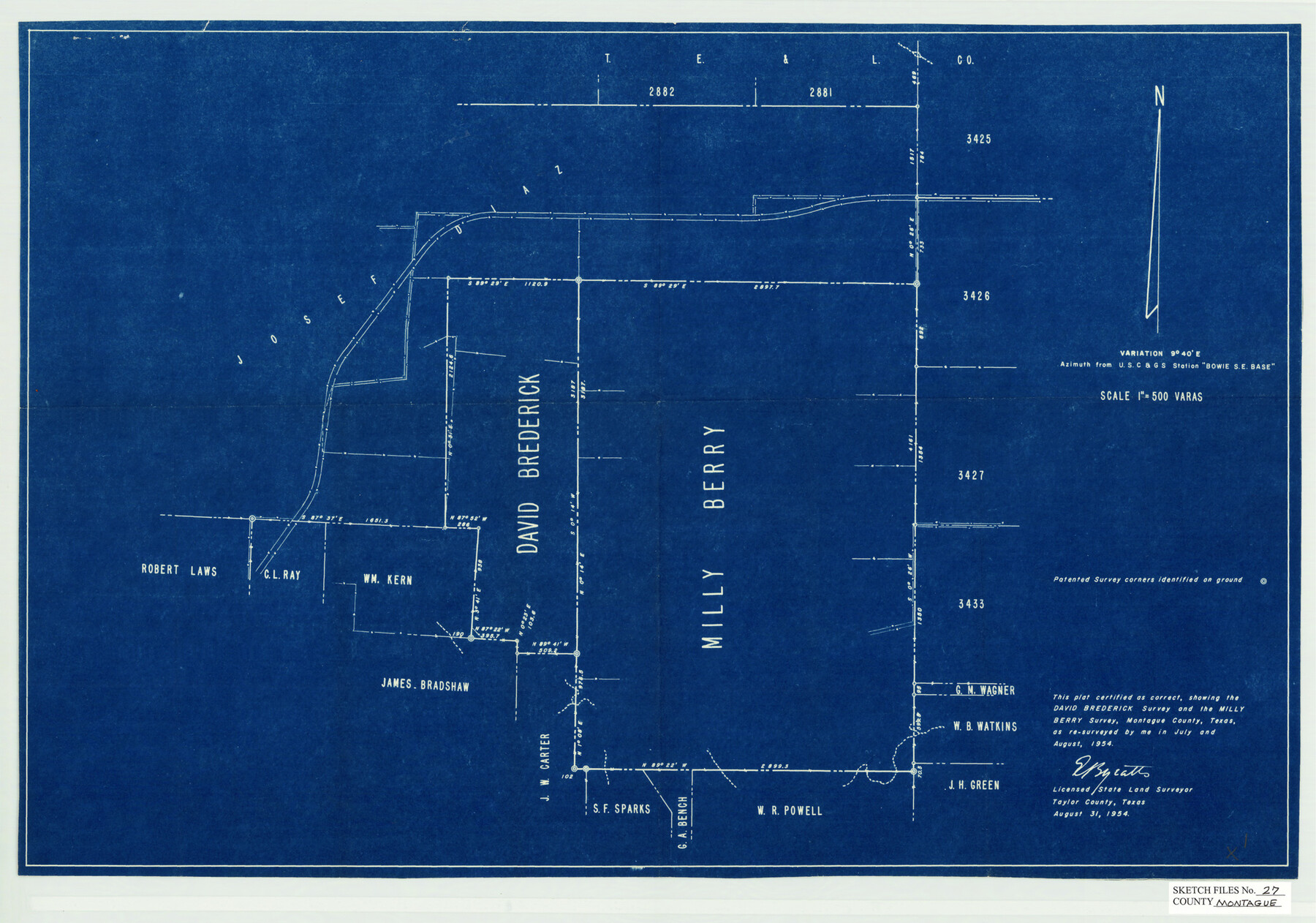
[Sketch of the David Brederick and Milly Berry surveys in the southwest part of the county]
-
Map/Doc
12109
-
Collection
General Map Collection
-
Object Dates
8/31/1954 (Creation Date)
10/13/1954 (File Date)
7 & 8/1954 (Survey Date)
-
People and Organizations
E.B. Yeatts (Surveyor/Engineer)
-
Counties
Montague
-
Subjects
Surveying Sketch File
-
Height x Width
15.8 x 22.5 inches
40.1 x 57.2 cm
-
Medium
blueprint/diazo
-
Scale
1" = 500 varas
Part of: General Map Collection
Dimmit County Working Sketch 34

Print $20.00
- Digital $50.00
Dimmit County Working Sketch 34
1959
Size 22.8 x 17.0 inches
Map/Doc 68695
Glasscock County Working Sketch 6

Print $20.00
- Digital $50.00
Glasscock County Working Sketch 6
1945
Size 22.0 x 22.9 inches
Map/Doc 63179
Flight Mission No. DIX-6P, Frame 133, Aransas County

Print $20.00
- Digital $50.00
Flight Mission No. DIX-6P, Frame 133, Aransas County
1956
Size 19.6 x 23.3 inches
Map/Doc 83839
Crockett County Rolled Sketch 31

Print $40.00
- Digital $50.00
Crockett County Rolled Sketch 31
Size 58.1 x 50.0 inches
Map/Doc 8716
Calhoun County NRC Article 33.136 Sketch 3

Print $40.00
- Digital $50.00
Calhoun County NRC Article 33.136 Sketch 3
2000
Size 24.4 x 36.5 inches
Map/Doc 81914
Medina County Rolled Sketch 9

Print $20.00
- Digital $50.00
Medina County Rolled Sketch 9
Size 18.8 x 31.0 inches
Map/Doc 6743
Hardeman County Sketch File 5

Print $6.00
- Digital $50.00
Hardeman County Sketch File 5
Size 12.9 x 4.4 inches
Map/Doc 24994
Pecos County Sketch File 85

Print $19.00
- Digital $50.00
Pecos County Sketch File 85
1948
Size 14.6 x 9.2 inches
Map/Doc 33955
North Sulphur River, Kinsing Sheet

Print $20.00
- Digital $50.00
North Sulphur River, Kinsing Sheet
1925
Size 18.6 x 23.4 inches
Map/Doc 78331
Panola County Rolled Sketch 7

Print $20.00
- Digital $50.00
Panola County Rolled Sketch 7
Size 18.6 x 23.4 inches
Map/Doc 7200
Flight Mission No. DIX-5P, Frame 106, Aransas County

Print $20.00
- Digital $50.00
Flight Mission No. DIX-5P, Frame 106, Aransas County
1956
Size 17.8 x 18.0 inches
Map/Doc 83784
Liberty County Working Sketch 43

Print $20.00
- Digital $50.00
Liberty County Working Sketch 43
1953
Size 30.6 x 43.7 inches
Map/Doc 70502
You may also like
Hudspeth County Rolled Sketch 53

Print $77.00
- Digital $50.00
Hudspeth County Rolled Sketch 53
1977
Size 9.9 x 15.1 inches
Map/Doc 45849
Flight Mission No. DIX-8P, Frame 64, Aransas County

Print $20.00
- Digital $50.00
Flight Mission No. DIX-8P, Frame 64, Aransas County
1956
Size 18.7 x 22.4 inches
Map/Doc 83895
Dawson County Rolled Sketch 12

Print $20.00
- Digital $50.00
Dawson County Rolled Sketch 12
1965
Size 15.6 x 33.2 inches
Map/Doc 5695
Hopkins County Boundary File 3a

Print $4.00
- Digital $50.00
Hopkins County Boundary File 3a
Size 10.7 x 8.7 inches
Map/Doc 55082
Bosque County Working Sketch 11

Print $20.00
- Digital $50.00
Bosque County Working Sketch 11
1952
Size 10.8 x 30.4 inches
Map/Doc 67444
Val Verde County Working Sketch 120

Print $40.00
- Digital $50.00
Val Verde County Working Sketch 120
2005
Size 30.7 x 50.0 inches
Map/Doc 83589
Flight Mission No. CRK-5P, Frame 158, Refugio County

Print $20.00
- Digital $50.00
Flight Mission No. CRK-5P, Frame 158, Refugio County
1956
Size 18.6 x 22.5 inches
Map/Doc 86939
[Sketch for Mineral Application 33721 - 33725 Incl. - Padre and Mustang Island]
![2876, [Sketch for Mineral Application 33721 - 33725 Incl. - Padre and Mustang Island], General Map Collection](https://historictexasmaps.com/wmedia_w700/maps/2876.tif.jpg)
Print $20.00
- Digital $50.00
[Sketch for Mineral Application 33721 - 33725 Incl. - Padre and Mustang Island]
1942
Size 29.1 x 23.0 inches
Map/Doc 2876
Brown County Sketch File 27

Print $4.00
- Digital $50.00
Brown County Sketch File 27
1868
Size 13.3 x 8.1 inches
Map/Doc 16624
Map of Hopkins Co.

Print $20.00
- Digital $50.00
Map of Hopkins Co.
1885
Size 36.6 x 38.7 inches
Map/Doc 4982
[Part of Block M6]
![91933, [Part of Block M6], Twichell Survey Records](https://historictexasmaps.com/wmedia_w700/maps/91933-1.tif.jpg)
Print $20.00
- Digital $50.00
[Part of Block M6]
Size 31.5 x 6.7 inches
Map/Doc 91933
Flight Mission No. DCL-4C, Frame 68, Kenedy County

Print $20.00
- Digital $50.00
Flight Mission No. DCL-4C, Frame 68, Kenedy County
1943
Size 18.7 x 22.3 inches
Map/Doc 85813