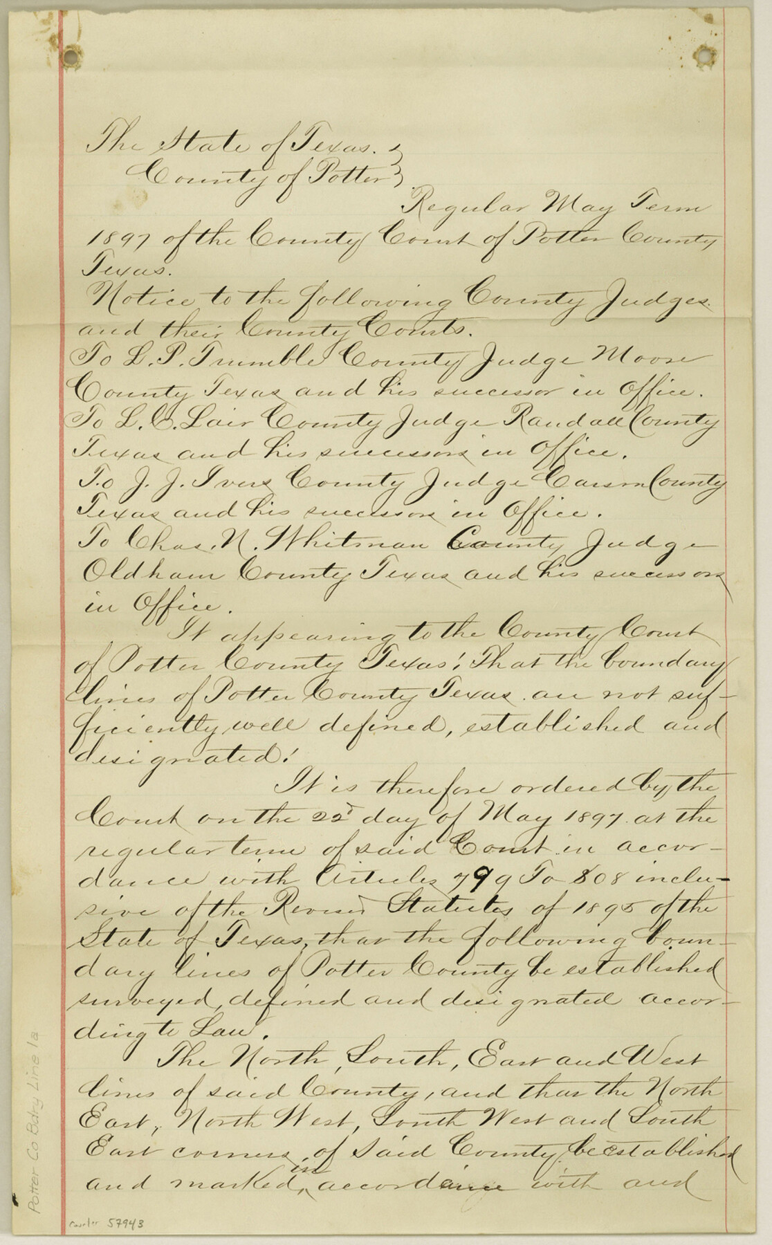
Potter County Boundary File 1a
Order of the County Court of Potter County
-
Map/Doc
57943
-
Collection
General Map Collection
-
Counties
Potter
-
Subjects
County Boundaries
-
Height x Width
14.1 x 8.8 inches
35.8 x 22.4 cm
Part of: General Map Collection

Childress County Rolled Sketch 4

Print $20.00
- Digital $50.00
Childress County Rolled Sketch 4
1891
Size 18.8 x 42.2 inches
Map/Doc 5438
Old Miscellaneous File 4

Print $22.00
- Digital $50.00
Old Miscellaneous File 4
1845
Size 16.5 x 20.8 inches
Map/Doc 75416
Harbor of Brazos Santiago, Texas

Print $20.00
- Digital $50.00
Harbor of Brazos Santiago, Texas
1887
Size 27.3 x 18.3 inches
Map/Doc 72992
[Map of Texas and Pacific Blocks from Brazos River westward through Palo Pinto, Stephens, Shackelford, Jones, Callahan, Taylor, Fisher, Nolan and Mitchell Counties]
![64510, [Map of Texas and Pacific Blocks from Brazos River westward through Palo Pinto, Stephens, Shackelford, Jones, Callahan, Taylor, Fisher, Nolan and Mitchell Counties], General Map Collection](https://historictexasmaps.com/wmedia_w700/maps/64510-1.tif.jpg)
Print $20.00
- Digital $50.00
[Map of Texas and Pacific Blocks from Brazos River westward through Palo Pinto, Stephens, Shackelford, Jones, Callahan, Taylor, Fisher, Nolan and Mitchell Counties]
Size 35.5 x 19.0 inches
Map/Doc 64510
Johnson County Working Sketch 2

Print $20.00
- Digital $50.00
Johnson County Working Sketch 2
Size 20.8 x 20.2 inches
Map/Doc 66615
Dimmit County Sketch File 20

Print $6.00
- Digital $50.00
Dimmit County Sketch File 20
1884
Size 13.0 x 8.7 inches
Map/Doc 21100
Sabine River, Watershed of the Sabine and Neches Rivers

Print $20.00
- Digital $50.00
Sabine River, Watershed of the Sabine and Neches Rivers
Size 39.5 x 36.0 inches
Map/Doc 65132
Intracoastal Waterway in Texas - Corpus Christi to Point Isabel including Arroyo Colorado to Mo. Pac. R.R. Bridge Near Harlingen

Print $20.00
- Digital $50.00
Intracoastal Waterway in Texas - Corpus Christi to Point Isabel including Arroyo Colorado to Mo. Pac. R.R. Bridge Near Harlingen
1933
Size 28.0 x 41.0 inches
Map/Doc 61860
Blanco County Rolled Sketch 22

Print $20.00
- Digital $50.00
Blanco County Rolled Sketch 22
2007
Size 17.4 x 11.4 inches
Map/Doc 87926
Foard County Working Sketch 6

Print $20.00
- Digital $50.00
Foard County Working Sketch 6
1944
Size 43.4 x 31.4 inches
Map/Doc 69197
Crockett County Rolled Sketch 72

Print $20.00
- Digital $50.00
Crockett County Rolled Sketch 72
1949
Size 26.9 x 22.0 inches
Map/Doc 5613
You may also like
Louisiana and Texas Intracoastal Waterway, Section 7, Galveston Bay to Brazos River and Section 8, Brazos River to Matagorda Bay

Print $20.00
- Digital $50.00
Louisiana and Texas Intracoastal Waterway, Section 7, Galveston Bay to Brazos River and Section 8, Brazos River to Matagorda Bay
1937
Size 31.0 x 42.8 inches
Map/Doc 61843
A Topographical Map of the City of Austin

Print $20.00
- Digital $50.00
A Topographical Map of the City of Austin
1872
Size 21.0 x 14.7 inches
Map/Doc 4821

Map of Parker County

Print $20.00
- Digital $50.00
Map of Parker County
1871
Size 20.1 x 17.0 inches
Map/Doc 3944
Map of Dalhart, Dallam & Hartley Co's, Texas

Print $20.00
- Digital $50.00
Map of Dalhart, Dallam & Hartley Co's, Texas
Size 22.7 x 35.2 inches
Map/Doc 92125
Wood County Sketch File 9

Print $4.00
- Digital $50.00
Wood County Sketch File 9
1852
Size 7.4 x 8.9 inches
Map/Doc 40656
Flight Mission No. DAG-17K, Frame 63, Matagorda County

Print $20.00
- Digital $50.00
Flight Mission No. DAG-17K, Frame 63, Matagorda County
1952
Size 18.6 x 22.3 inches
Map/Doc 86325
Official Map of the Highway System of Texas

Print $20.00
Official Map of the Highway System of Texas
1933
Size 26.1 x 27.0 inches
Map/Doc 79308
Right of Way and Track Map, Dayton-Goose Creek Ry. Co., Station 401+20 to Station 612+40
Print $40.00
- Digital $50.00
Right of Way and Track Map, Dayton-Goose Creek Ry. Co., Station 401+20 to Station 612+40
1917
Size 25.4 x 56.4 inches
Map/Doc 64367
Brewster County Sketch File NS-3

Print $40.00
- Digital $50.00
Brewster County Sketch File NS-3
1913
Size 30.9 x 15.6 inches
Map/Doc 10986
Crane County Working Sketch 16

Print $20.00
- Digital $50.00
Crane County Working Sketch 16
1955
Size 42.8 x 22.0 inches
Map/Doc 68293
H No. 4 - Horn Island Pass, Mississippi Sound

Print $20.00
- Digital $50.00
H No. 4 - Horn Island Pass, Mississippi Sound
1852
Size 14.9 x 19.0 inches
Map/Doc 97225