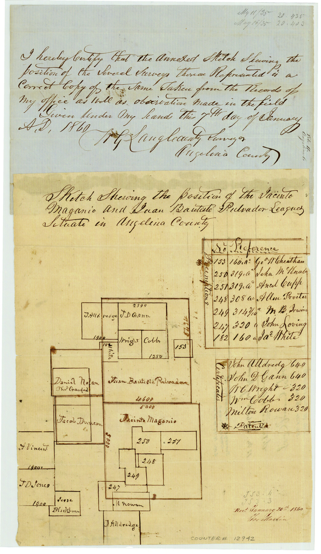
Angelina County Sketch File 11a
[Sketch of surveys around the Magano league north and west of Lufkin]
-
Map/Doc
12942
-
Collection
General Map Collection
-
Object Dates
1860/1/7 (Creation Date)
1860/1/20 (File Date)
-
People and Organizations
W.G. Lang (Surveyor/Engineer)
-
Counties
Angelina
-
Subjects
Surveying Sketch File
-
Height x Width
14.4 x 8.3 inches
36.6 x 21.1 cm
-
Medium
paper, manuscript
Part of: General Map Collection
Runnels County Working Sketch 9

Print $40.00
- Digital $50.00
Runnels County Working Sketch 9
1948
Size 48.9 x 27.9 inches
Map/Doc 63605
Wood County Working Sketch 4

Print $20.00
- Digital $50.00
Wood County Working Sketch 4
1941
Size 21.0 x 28.3 inches
Map/Doc 62004
Flight Mission No. CRC-3R, Frame 164, Chambers County

Print $20.00
- Digital $50.00
Flight Mission No. CRC-3R, Frame 164, Chambers County
1956
Size 18.7 x 22.3 inches
Map/Doc 84846
La Salle County Rolled Sketch 26

Print $20.00
- Digital $50.00
La Salle County Rolled Sketch 26
1969
Size 23.6 x 24.7 inches
Map/Doc 6587
Pecos County Rolled Sketch 95

Print $20.00
- Digital $50.00
Pecos County Rolled Sketch 95
Size 18.6 x 25.9 inches
Map/Doc 7247
Kimble County Sketch File 11

Print $40.00
- Digital $50.00
Kimble County Sketch File 11
1882
Size 20.5 x 10.2 inches
Map/Doc 28933
Lamar County Sketch File 16

Print $166.00
- Digital $50.00
Lamar County Sketch File 16
2013
Size 11.0 x 8.5 inches
Map/Doc 93654
Lipscomb County Rolled Sketch 1

Print $40.00
- Digital $50.00
Lipscomb County Rolled Sketch 1
Size 65.0 x 15.8 inches
Map/Doc 9449
Presidio County Sketch File P2

Print $6.00
- Digital $50.00
Presidio County Sketch File P2
Size 14.3 x 8.9 inches
Map/Doc 34558
A Map of Sterling County

Print $20.00
- Digital $50.00
A Map of Sterling County
1919
Size 33.3 x 21.6 inches
Map/Doc 4054
San Patricio County NRC Article 33.136 Sketch 8

Print $26.00
- Digital $50.00
San Patricio County NRC Article 33.136 Sketch 8
2018
Size 11.0 x 17.0 inches
Map/Doc 95341
Kent County Sketch File 7

Print $20.00
- Digital $50.00
Kent County Sketch File 7
1902
Size 21.7 x 37.6 inches
Map/Doc 10514
You may also like
Kendall County Sketch File 5

Print $4.00
- Digital $50.00
Kendall County Sketch File 5
1854
Size 8.7 x 7.6 inches
Map/Doc 28686
Controlled Mosaic by Jack Amman Photogrammetric Engineers, Inc - Sheet 14

Print $20.00
- Digital $50.00
Controlled Mosaic by Jack Amman Photogrammetric Engineers, Inc - Sheet 14
1954
Size 20.0 x 24.0 inches
Map/Doc 83458
Marion County Rolled Sketch F

Print $40.00
- Digital $50.00
Marion County Rolled Sketch F
1937
Size 43.5 x 67.1 inches
Map/Doc 9487
Brewster County Sketch File N-23

Print $6.00
- Digital $50.00
Brewster County Sketch File N-23
1951
Size 14.4 x 9.0 inches
Map/Doc 15697
Kleberg County Rolled Sketch 10-25

Print $20.00
- Digital $50.00
Kleberg County Rolled Sketch 10-25
1952
Size 38.1 x 35.8 inches
Map/Doc 9365
Bandera County Working Sketch 30

Print $20.00
- Digital $50.00
Bandera County Working Sketch 30
1969
Size 29.9 x 37.4 inches
Map/Doc 67626

Galveston County Sketch File 12

Print $6.00
- Digital $50.00
Galveston County Sketch File 12
1886
Size 15.7 x 11.4 inches
Map/Doc 23380
Motley County Sketch File 2 (S)

Print $20.00
- Digital $50.00
Motley County Sketch File 2 (S)
Size 31.1 x 25.1 inches
Map/Doc 42133
Flight Mission No. BRE-2P, Frame 54, Nueces County

Print $20.00
- Digital $50.00
Flight Mission No. BRE-2P, Frame 54, Nueces County
1956
Size 18.5 x 22.4 inches
Map/Doc 86756
Fort Bend County Boundary File 1

Print $80.00
- Digital $50.00
Fort Bend County Boundary File 1
Size 25.0 x 69.7 inches
Map/Doc 53553
Zapata County Rolled Sketch 10A

Print $20.00
- Digital $50.00
Zapata County Rolled Sketch 10A
1912
Size 26.3 x 26.5 inches
Map/Doc 8312