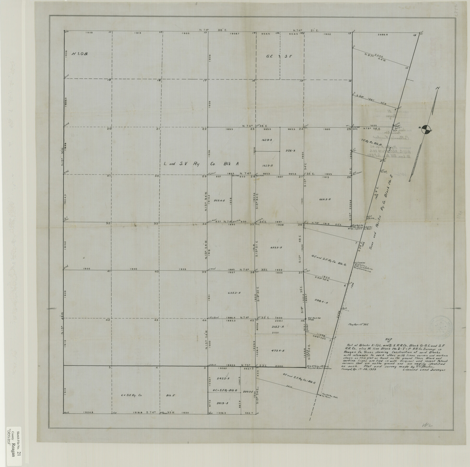
Reagan County Sketch File 21
Pt. of Blks. A-F & L & S.W. RR Co., Blk. O, GC & SH RR. Co. W. Line Blk, No. 2 T&PRR. Co.
-
Map/Doc
10585
-
Collection
General Map Collection
-
Object Dates
1939/4/28 (Creation Date)
1939/6/1 (File Date)
1939/4/28 (Survey Date)
-
People and Organizations
V.V. Strahan (Surveyor/Engineer)
-
Counties
Reagan
-
Subjects
Surveying Sketch File
-
Height x Width
31.1 x 31.3 inches
79.0 x 79.5 cm
-
Medium
paper, manuscript
Part of: General Map Collection
Sketch of Robertson Co., Tehuacana Creek

Print $3.00
- Digital $50.00
Sketch of Robertson Co., Tehuacana Creek
1846
Size 10.3 x 16.4 inches
Map/Doc 264
Limestone County Working Sketch 24

Print $20.00
- Digital $50.00
Limestone County Working Sketch 24
1980
Size 28.9 x 31.6 inches
Map/Doc 70574
Kaufman County State Real Property Sketch 1

Print $92.00
- Digital $50.00
Kaufman County State Real Property Sketch 1
2006
Size 24.6 x 35.4 inches
Map/Doc 88624
Bandera County Working Sketch 19

Print $20.00
- Digital $50.00
Bandera County Working Sketch 19
1946
Size 43.3 x 35.8 inches
Map/Doc 67615
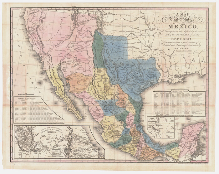
A Map of the United States of Mexico as organized and defined by the several Acts of the Congress of that Republic
Print $20.00
- Digital $50.00
A Map of the United States of Mexico as organized and defined by the several Acts of the Congress of that Republic
Size 25.3 x 31.8 inches
Map/Doc 95913
Mason County Sketch File 17

Print $4.00
- Digital $50.00
Mason County Sketch File 17
Size 8.4 x 12.4 inches
Map/Doc 30705
Midland County Boundary File 4

Print $18.00
- Digital $50.00
Midland County Boundary File 4
Size 8.8 x 8.0 inches
Map/Doc 57176
Cottle County Sketch File 16

Print $8.00
- Digital $50.00
Cottle County Sketch File 16
1911
Size 10.7 x 8.7 inches
Map/Doc 19518
Kent County Working Sketch 12

Print $20.00
- Digital $50.00
Kent County Working Sketch 12
1953
Size 33.8 x 24.3 inches
Map/Doc 70019
Kent County Working Sketch 2

Print $20.00
- Digital $50.00
Kent County Working Sketch 2
1947
Size 43.7 x 42.7 inches
Map/Doc 70008
Castro County Sketch File 4i

Print $4.00
- Digital $50.00
Castro County Sketch File 4i
Size 13.6 x 8.9 inches
Map/Doc 17481

You may also like
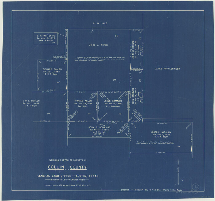
Collin County Working Sketch 4
Print $20.00
- Digital $50.00
Collin County Working Sketch 4
1953
Size 20.4 x 21.8 inches
Map/Doc 68098
Copy of Surveyor's Field Book, Morris Browning - In Blocks 7, 5 & 4, I&GNRRCo., Hutchinson and Carson Counties, Texas

Print $2.00
- Digital $50.00
Copy of Surveyor's Field Book, Morris Browning - In Blocks 7, 5 & 4, I&GNRRCo., Hutchinson and Carson Counties, Texas
1888
Size 7.0 x 8.8 inches
Map/Doc 62278
Crockett County Sketch File 99

Print $14.00
- Digital $50.00
Crockett County Sketch File 99
1925
Size 14.4 x 9.4 inches
Map/Doc 19980
Duval County Working Sketch 52

Print $20.00
- Digital $50.00
Duval County Working Sketch 52
1942
Size 22.1 x 25.9 inches
Map/Doc 68776
Flight Mission No. CRK-3P, Frame 130, Refugio County

Print $20.00
- Digital $50.00
Flight Mission No. CRK-3P, Frame 130, Refugio County
1956
Size 18.6 x 22.3 inches
Map/Doc 86918
Dickens County Sketch File 14

Print $20.00
- Digital $50.00
Dickens County Sketch File 14
Size 19.6 x 16.6 inches
Map/Doc 11320
Dallam County Boundary File 2

Print $18.00
- Digital $50.00
Dallam County Boundary File 2
Size 8.7 x 4.3 inches
Map/Doc 52053
[Sketch for Mineral Application 12206 - Cow Bayou, O. B. Sawyer]
![65567, [Sketch for Mineral Application 12206 - Cow Bayou, O. B. Sawyer], General Map Collection](https://historictexasmaps.com/wmedia_w700/maps/65567.tif.jpg)
Print $40.00
- Digital $50.00
[Sketch for Mineral Application 12206 - Cow Bayou, O. B. Sawyer]
Size 140.6 x 37.5 inches
Map/Doc 65567
The Republic County of Fannin. November 28. 1839

Print $20.00
The Republic County of Fannin. November 28. 1839
2020
Size 12.9 x 21.7 inches
Map/Doc 96129
Bastrop County Boundary File 3

Print $48.00
- Digital $50.00
Bastrop County Boundary File 3
1925
Size 11.3 x 8.7 inches
Map/Doc 50320
Uvalde County Working Sketch 43

Print $20.00
- Digital $50.00
Uvalde County Working Sketch 43
1978
Size 29.3 x 27.7 inches
Map/Doc 72113
Dawn on the Delta 74 Million Years Ago

Dawn on the Delta 74 Million Years Ago
1993
Size 20.6 x 27.3 inches
Map/Doc 96832