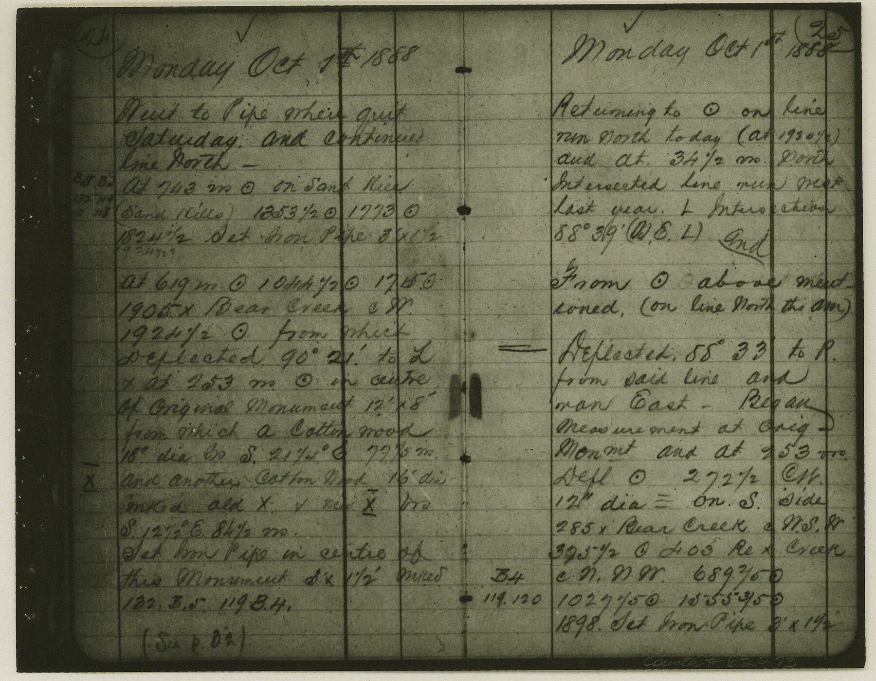
Copy of Surveyor's Field Book, Morris Browning - In Blocks 7, 5 & 4, I&GNRRCo., Hutchinson and Carson Counties, Texas
K-7-70
-
Map/Doc
62273
-
Collection
General Map Collection
-
Object Dates
1888/10/22 (Creation Date)
-
People and Organizations
Morris Browning (Surveyor/Engineer)
-
Counties
Hutchinson Carson
-
Height x Width
6.9 x 8.9 inches
17.5 x 22.6 cm
-
Comments
Copy of Surveyor's field book presented to the General Land Office by Morris Browning on February 3, 1941.
Surveyed from September 14, 1888 to October 22, 1888.
Part of: General Map Collection
Harris County Historic Topographic 21

Print $20.00
- Digital $50.00
Harris County Historic Topographic 21
1915
Size 29.2 x 22.5 inches
Map/Doc 65832
Culberson County Working Sketch 64

Print $20.00
- Digital $50.00
Culberson County Working Sketch 64
1975
Size 46.5 x 30.8 inches
Map/Doc 68518
Texas, San Antonio Bay, Guadalupe Bay

Print $40.00
- Digital $50.00
Texas, San Antonio Bay, Guadalupe Bay
1934
Size 28.8 x 48.4 inches
Map/Doc 69999
170th Anniversary Land Commissioners of the Texas General Land Office

Print $20.00
- Digital $50.00
170th Anniversary Land Commissioners of the Texas General Land Office
2006
Size 36.4 x 24.1 inches
Map/Doc 87177
Galveston County NRC Article 33.136 Location Key Sheet

Print $20.00
- Digital $50.00
Galveston County NRC Article 33.136 Location Key Sheet
1994
Size 27.0 x 21.8 inches
Map/Doc 77024
Guadalupe County Sketch File 15e

Print $6.00
- Digital $50.00
Guadalupe County Sketch File 15e
Size 9.9 x 8.1 inches
Map/Doc 24707
Current Miscellaneous File 109

Print $9.00
- Digital $50.00
Current Miscellaneous File 109
1967
Size 9.7 x 10.3 inches
Map/Doc 74710
Mills County Working Sketch 26

Print $20.00
- Digital $50.00
Mills County Working Sketch 26
1993
Size 18.2 x 26.2 inches
Map/Doc 71056
Val Verde County Working Sketch 82

Print $20.00
- Digital $50.00
Val Verde County Working Sketch 82
1973
Size 42.1 x 33.1 inches
Map/Doc 72217
Webb County Sketch File C1

Print $10.00
- Digital $50.00
Webb County Sketch File C1
1915
Size 14.3 x 8.9 inches
Map/Doc 39673
Shelby County Sketch File 13

Print $2.00
- Digital $50.00
Shelby County Sketch File 13
1859
Size 8.2 x 12.8 inches
Map/Doc 36621
Brewster County Sketch File 53

Print $94.00
- Digital $50.00
Brewster County Sketch File 53
1910
Size 13.3 x 8.9 inches
Map/Doc 16361
You may also like
Duval County Rolled Sketch 44A

Print $40.00
- Digital $50.00
Duval County Rolled Sketch 44A
1981
Size 37.8 x 91.9 inches
Map/Doc 9062
Austin County

Print $20.00
- Digital $50.00
Austin County
1943
Size 38.5 x 41.3 inches
Map/Doc 77205
Montgomery County Rolled Sketch 30

Print $40.00
- Digital $50.00
Montgomery County Rolled Sketch 30
1949
Size 34.6 x 51.3 inches
Map/Doc 9538
Flight Mission No. BRA-9M, Frame 81, Jefferson County

Print $20.00
- Digital $50.00
Flight Mission No. BRA-9M, Frame 81, Jefferson County
1953
Size 18.3 x 22.6 inches
Map/Doc 85664
Galveston County Rolled Sketch 26

Print $950.00
- Digital $50.00
Galveston County Rolled Sketch 26
Size 10.6 x 16.1 inches
Map/Doc 44849
Bien & Sterner’s New Rail Road Map of the United States

Price $20.00
Bien & Sterner’s New Rail Road Map of the United States
2022
Size 3.6 x 4.9 inches
Map/Doc 97020
Map of the post of Fort Brown, Brownsville, Texas

Print $20.00
Map of the post of Fort Brown, Brownsville, Texas
1877
Size 24.0 x 33.9 inches
Map/Doc 93560
Right of Way and Track Map, International & Gt. Northern Ry. Operated by the International & Gt. Northern Ry. Co., Gulf Division

Print $40.00
- Digital $50.00
Right of Way and Track Map, International & Gt. Northern Ry. Operated by the International & Gt. Northern Ry. Co., Gulf Division
1917
Size 25.2 x 55.9 inches
Map/Doc 64253
Map of north end of Brazos Island

Print $20.00
- Digital $50.00
Map of north end of Brazos Island
1845
Size 24.3 x 18.3 inches
Map/Doc 72918
Cooke County Sketch File 12

Print $4.00
- Digital $50.00
Cooke County Sketch File 12
Size 10.1 x 8.3 inches
Map/Doc 19246
Map of the United States of America with its territories and districts including also a part of upper and lower Canada and Mexico

Print $20.00
- Digital $50.00
Map of the United States of America with its territories and districts including also a part of upper and lower Canada and Mexico
1835
Size 31.3 x 44.7 inches
Map/Doc 93852
Flight Mission No. DIX-6P, Frame 200, Aransas County

Print $20.00
- Digital $50.00
Flight Mission No. DIX-6P, Frame 200, Aransas County
1956
Size 19.0 x 22.7 inches
Map/Doc 83862