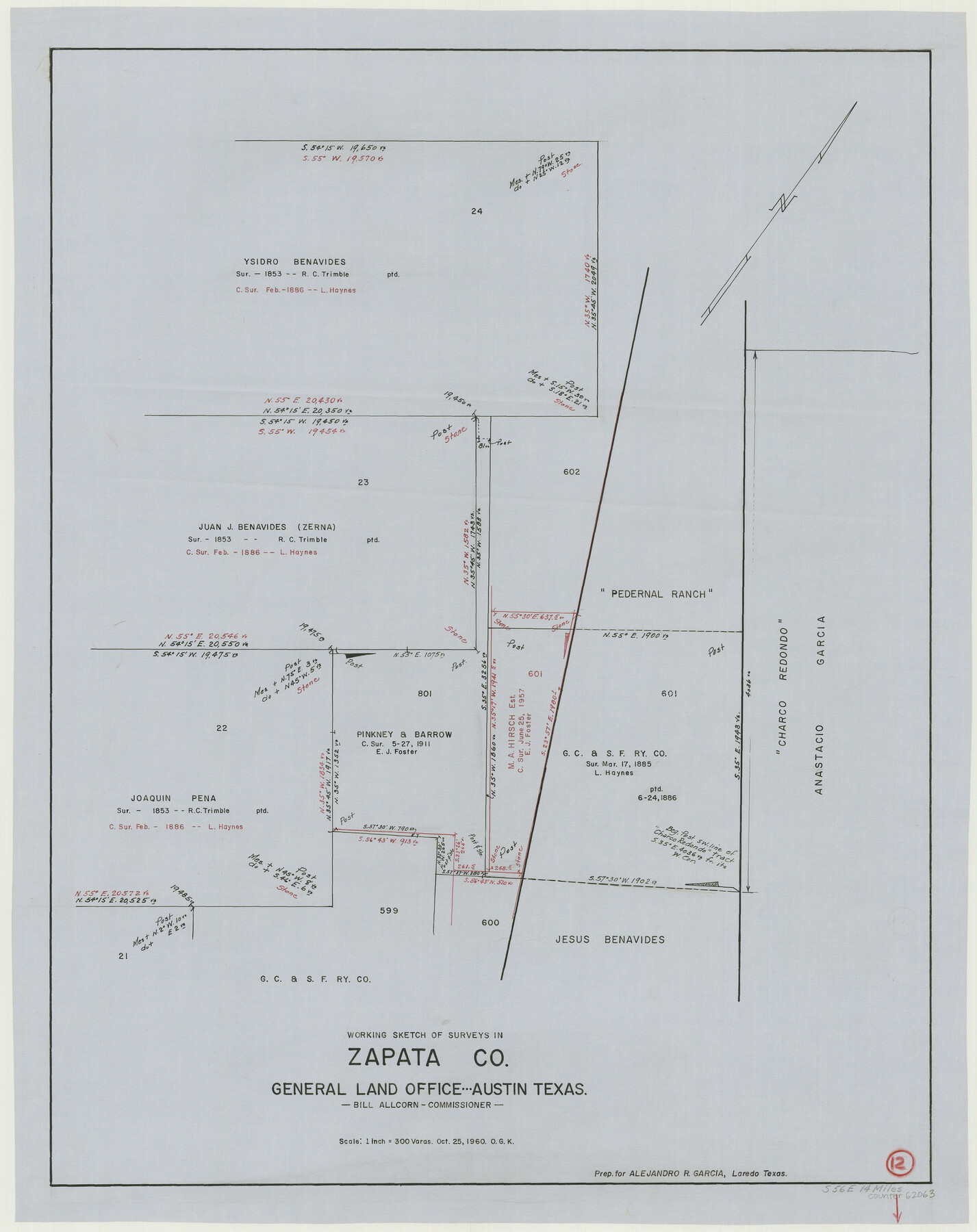
Zapata County Working Sketch 12
-
Map/Doc
62063
-
Collection
General Map Collection
-
Object Dates
10/25/1960 (Creation Date)
-
People and Organizations
Otto G. Kurio (Draftsman)
-
Counties
Zapata
-
Subjects
Surveying Working Sketch
-
Height x Width
30.8 x 24.4 inches
78.2 x 62.0 cm
-
Scale
1" = 300 varas
Part of: General Map Collection
Jeff Davis Co.

Print $20.00
- Digital $50.00
Jeff Davis Co.
1893
Size 27.4 x 47.9 inches
Map/Doc 66880
San Patricio County Sketch File 40

Print $4.00
- Digital $50.00
San Patricio County Sketch File 40
1842
Size 10.5 x 8.2 inches
Map/Doc 36236
Calhoun County Working Sketch 14

Print $20.00
- Digital $50.00
Calhoun County Working Sketch 14
1991
Size 28.7 x 33.9 inches
Map/Doc 67830
No. 1 - Survey for a road from the Brazo Santiago to the Rio Grande

Print $20.00
- Digital $50.00
No. 1 - Survey for a road from the Brazo Santiago to the Rio Grande
1847
Size 18.3 x 27.1 inches
Map/Doc 72877
Grayson County Boundary File 3a

Print $25.00
- Digital $50.00
Grayson County Boundary File 3a
Size 8.3 x 16.9 inches
Map/Doc 53945
Flight Mission No. DAG-18K, Frame 185, Matagorda County

Print $20.00
- Digital $50.00
Flight Mission No. DAG-18K, Frame 185, Matagorda County
1952
Size 16.2 x 15.9 inches
Map/Doc 86377
Burleson County Working Sketch 26

Print $20.00
- Digital $50.00
Burleson County Working Sketch 26
1981
Size 10.1 x 30.5 inches
Map/Doc 67745
Hudspeth County Rolled Sketch 49

Print $40.00
- Digital $50.00
Hudspeth County Rolled Sketch 49
Size 42.8 x 53.8 inches
Map/Doc 9219


Brewster County Rolled Sketch 153

Print $20.00
- Digital $50.00
Brewster County Rolled Sketch 153
Size 32.4 x 19.2 inches
Map/Doc 5320
Roberts County Working Sketch 23

Print $20.00
- Digital $50.00
Roberts County Working Sketch 23
1979
Size 19.7 x 12.9 inches
Map/Doc 63549
You may also like
Plat of a survey of the North part of section 16, Block 362, Martha McBride, Presidio County, Texas

Print $20.00
- Digital $50.00
Plat of a survey of the North part of section 16, Block 362, Martha McBride, Presidio County, Texas
1989
Size 24.3 x 36.1 inches
Map/Doc 60523
Callahan County Working Sketch 13

Print $20.00
- Digital $50.00
Callahan County Working Sketch 13
1977
Size 23.8 x 27.6 inches
Map/Doc 67895
The Republic County of Victoria. Boundaries Refined, January 25, 1841

Print $20.00
The Republic County of Victoria. Boundaries Refined, January 25, 1841
2020
Size 19.3 x 21.8 inches
Map/Doc 96297
A New Map of Texas with the Contiguous American & Mexican States

Print $20.00
- Digital $50.00
A New Map of Texas with the Contiguous American & Mexican States
1835
Size 12.9 x 15.8 inches
Map/Doc 93853
General Highway Map. Detail of Cities and Towns in Harris County, Texas

Print $20.00
General Highway Map. Detail of Cities and Towns in Harris County, Texas
1939
Size 18.4 x 24.9 inches
Map/Doc 79117
Sabine Pass and mouth of the River Sabine in the sea

Print $20.00
- Digital $50.00
Sabine Pass and mouth of the River Sabine in the sea
1842
Size 24.0 x 19.1 inches
Map/Doc 93766
University Land Field Notes for Blocks 21 through 26 in Pecos County

University Land Field Notes for Blocks 21 through 26 in Pecos County
Map/Doc 81722

San Antonio & Aransas Pass RR Co., Fort Bend County, Texas

Print $2.00
- Digital $50.00
San Antonio & Aransas Pass RR Co., Fort Bend County, Texas
1898
Size 11.1 x 8.7 inches
Map/Doc 64142
Lampasas County Rolled Sketch 1

Print $20.00
- Digital $50.00
Lampasas County Rolled Sketch 1
1975
Size 22.0 x 28.2 inches
Map/Doc 6564
[I. G. Yates survey and adjacent area south of Runnels County School Land]
![91679, [I. G. Yates survey and adjacent area south of Runnels County School Land], Twichell Survey Records](https://historictexasmaps.com/wmedia_w700/maps/91679-1.tif.jpg)
Print $20.00
- Digital $50.00
[I. G. Yates survey and adjacent area south of Runnels County School Land]
Size 15.1 x 14.5 inches
Map/Doc 91679
Karnes County Sketch File 17

Print $4.00
- Digital $50.00
Karnes County Sketch File 17
1873
Size 12.8 x 8.0 inches
Map/Doc 28622