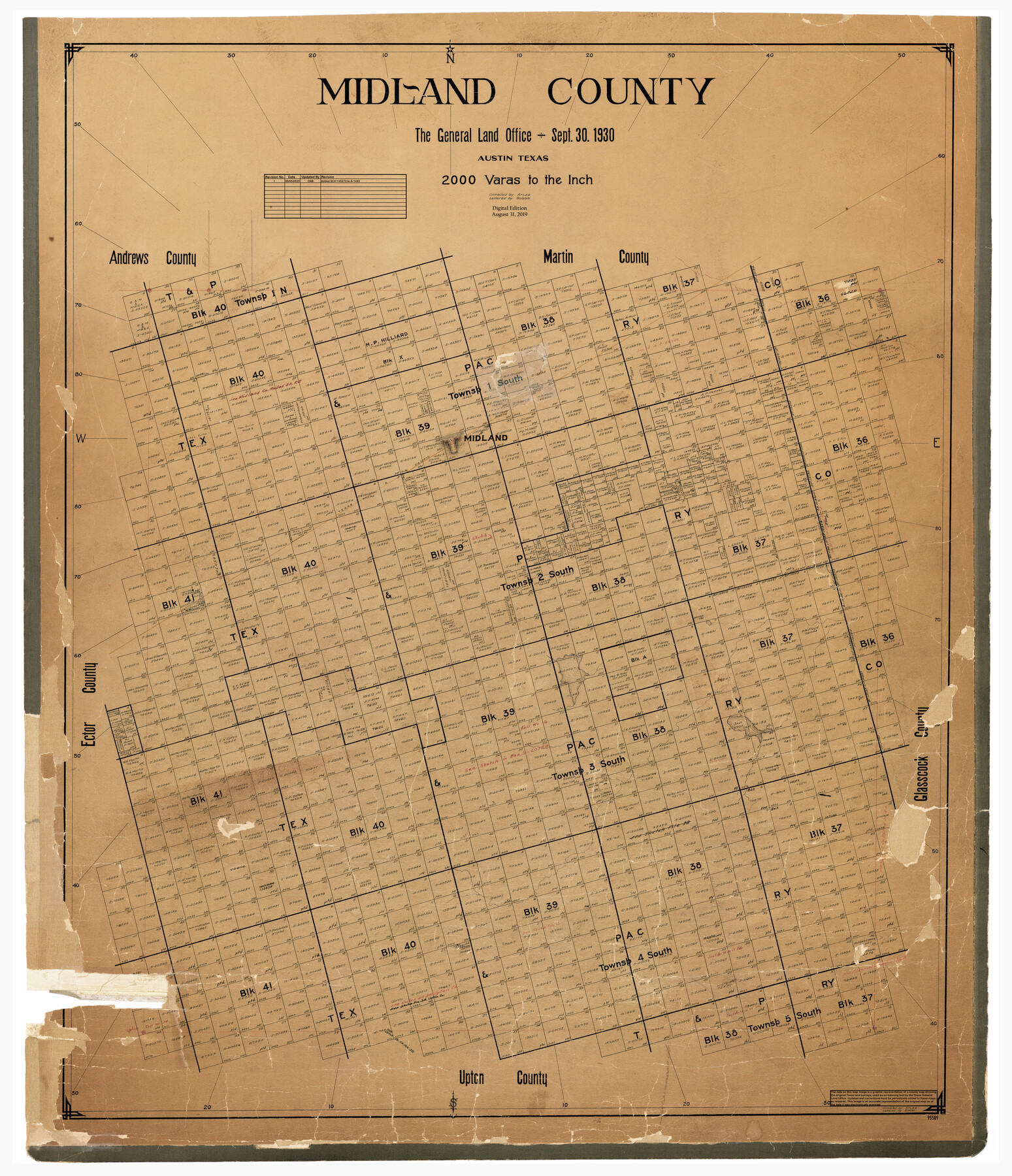
Midland County
General Land Office Official County Map
-
Map/Doc
95589
-
Collection
General Map Collection
-
Object Dates
8/31/2019 (Revision Date)
6/5/2020 (Revision Date)
9/30/1930 (Creation Date)
-
People and Organizations
Cheyenne Betancourt (Draftsman)
Atlee (Compiler)
Boggs (Draftsman)
-
Counties
Midland
-
Subjects
County OCM
-
Height x Width
45.9 x 39.5 inches
116.6 x 100.3 cm
-
Medium
digital image
-
Scale
1" = 2000 varas
Part of: General Map Collection
Mitchell County Sketch File 7A

Print $20.00
- Digital $50.00
Mitchell County Sketch File 7A
1906
Size 20.4 x 14.0 inches
Map/Doc 12097
Frio County Working Sketch 5

Print $20.00
- Digital $50.00
Frio County Working Sketch 5
1936
Size 33.9 x 23.0 inches
Map/Doc 69279
Northeast Part Pecos County

Print $20.00
- Digital $50.00
Northeast Part Pecos County
1975
Size 35.5 x 42.3 inches
Map/Doc 77394
Mason County Sketch File 9

Print $20.00
- Digital $50.00
Mason County Sketch File 9
1880
Size 20.5 x 13.9 inches
Map/Doc 12034
Hardeman Co[unty]
![16845, Hardeman Co[unty], General Map Collection](https://historictexasmaps.com/wmedia_w700/maps/16845.tif.jpg)
Print $40.00
- Digital $50.00
Hardeman Co[unty]
1886
Size 60.7 x 48.8 inches
Map/Doc 16845
Palestine, Texas

Print $20.00
- Digital $50.00
Palestine, Texas
1942
Size 39.3 x 36.1 inches
Map/Doc 4834

Kimble County Rolled Sketch 21

Print $20.00
- Digital $50.00
Kimble County Rolled Sketch 21
Size 10.5 x 18.2 inches
Map/Doc 6512
Gillespie County Sketch File 16

Print $20.00
- Digital $50.00
Gillespie County Sketch File 16
1951
Size 18.2 x 17.9 inches
Map/Doc 11557
Guadalupe County Sketch File 7c

Print $22.00
- Digital $50.00
Guadalupe County Sketch File 7c
Size 12.7 x 15.5 inches
Map/Doc 24672
Treaty to Resolve Pending Boundary Differences and Maintain the Rio Grande and Colorado River as the International Boundary Between the United States of American and Mexico

Print $4.00
- Digital $50.00
Treaty to Resolve Pending Boundary Differences and Maintain the Rio Grande and Colorado River as the International Boundary Between the United States of American and Mexico
1970
Size 12.2 x 19.0 inches
Map/Doc 83100
Flight Mission No. DQN-7K, Frame 32, Calhoun County

Print $20.00
- Digital $50.00
Flight Mission No. DQN-7K, Frame 32, Calhoun County
1953
Size 18.6 x 22.2 inches
Map/Doc 84470
You may also like
Ward County Working Sketch 39

Print $20.00
- Digital $50.00
Ward County Working Sketch 39
1969
Size 24.2 x 45.5 inches
Map/Doc 72345
Maverick County Sketch File 10

Print $22.00
- Digital $50.00
Maverick County Sketch File 10
Size 8.6 x 7.0 inches
Map/Doc 31072
La Salle County Rolled Sketch 19

Print $20.00
- Digital $50.00
La Salle County Rolled Sketch 19
1953
Size 31.8 x 30.0 inches
Map/Doc 6583
Shelby County Rolled Sketch 18

Print $20.00
- Digital $50.00
Shelby County Rolled Sketch 18
1975
Size 36.2 x 40.7 inches
Map/Doc 9926
Ward County Sketch File 2

Print $40.00
- Digital $50.00
Ward County Sketch File 2
Size 25.0 x 62.7 inches
Map/Doc 10426
Culberson County Sketch File 12a

Print $4.00
- Digital $50.00
Culberson County Sketch File 12a
1926
Size 14.3 x 8.8 inches
Map/Doc 20174
Webb County Rolled Sketch 28

Print $20.00
- Digital $50.00
Webb County Rolled Sketch 28
1932
Size 27.5 x 20.6 inches
Map/Doc 8186
[Map showing T&P Lands in El Paso County]
![88931, [Map showing T&P Lands in El Paso County], Library of Congress](https://historictexasmaps.com/wmedia_w700/maps/88931.tif.jpg)
Print $20.00
[Map showing T&P Lands in El Paso County]
Size 22.4 x 17.3 inches
Map/Doc 88931
Comanche County Sketch File 10

Print $4.00
- Digital $50.00
Comanche County Sketch File 10
1859
Size 8.4 x 16.0 inches
Map/Doc 19070
Cass County Rolled Sketch 5A

Print $20.00
- Digital $50.00
Cass County Rolled Sketch 5A
Size 15.4 x 18.0 inches
Map/Doc 5411
Galveston County NRC Article 33.136 Sketch 80

Print $24.00
- Digital $50.00
Galveston County NRC Article 33.136 Sketch 80
2014
Size 36.0 x 24.0 inches
Map/Doc 94987
Hudspeth County Rolled Sketch 41

Print $40.00
- Digital $50.00
Hudspeth County Rolled Sketch 41
1947
Size 12.6 x 83.1 inches
Map/Doc 76043