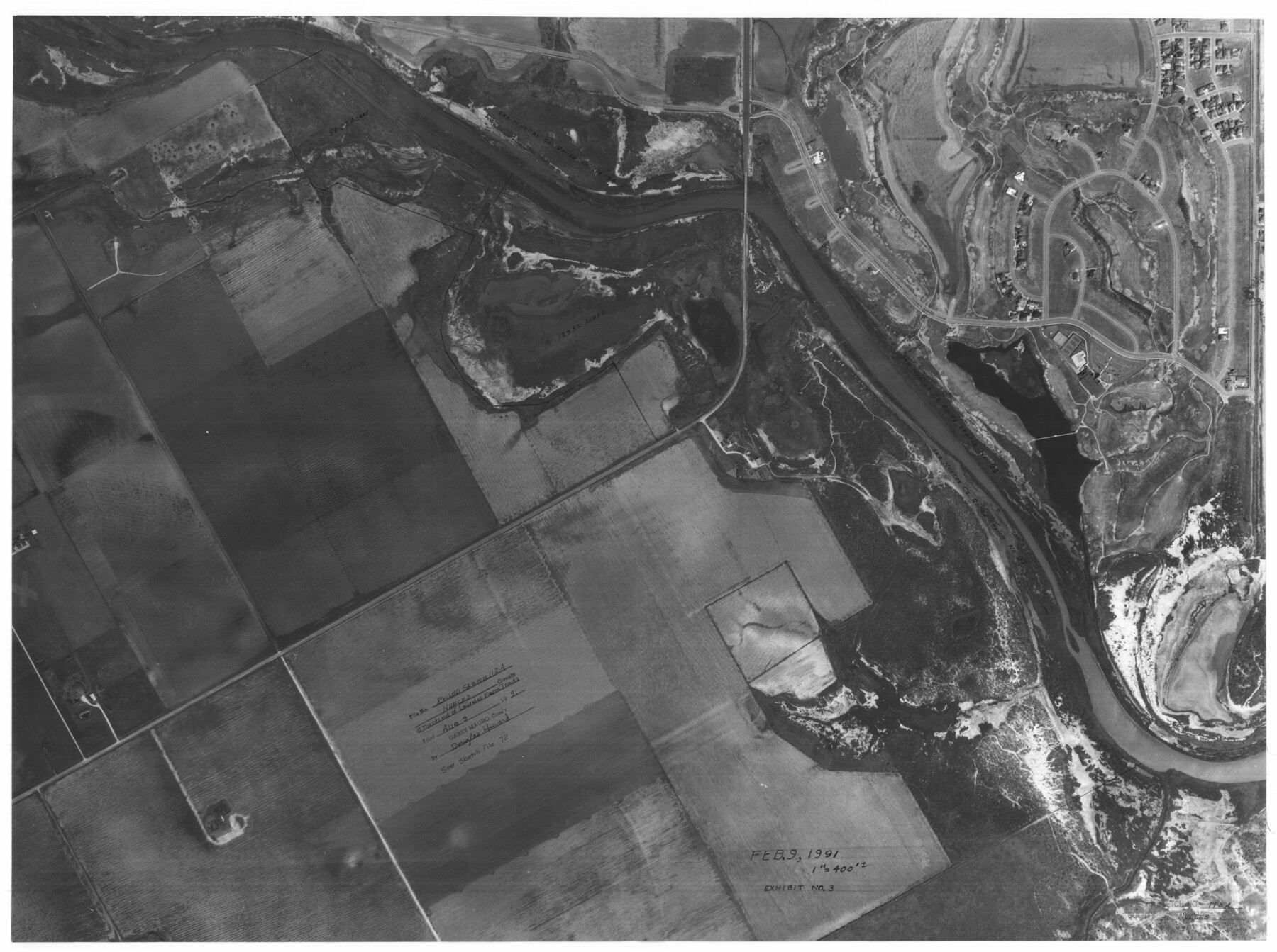
Nueces County Rolled Sketch 112A
Aerial Photo - Survey of Two Tracts of Land Out of Section 31 and Section A, Laureles Farm Tracts, Nueces County, Texas
-
Map/Doc
61779
-
Collection
General Map Collection
-
Object Dates
8/9/1991 (File Date)
2/9/1991 (Creation Date)
-
Counties
Nueces
-
Subjects
Surveying Rolled Sketch Aerial Photograph
-
Height x Width
24.7 x 33.1 inches
62.7 x 84.1 cm
-
Medium
photograph
-
Comments
See Nueces County Rolled Sketch 112 (7120) and Nueces County Sketch File 72 (33020).
Related maps
Nueces County Sketch File 72

Print $13.00
- Digital $50.00
Nueces County Sketch File 72
1991
Size 11.1 x 8.8 inches
Map/Doc 33020
Nueces County Rolled Sketch 112

Print $20.00
- Digital $50.00
Nueces County Rolled Sketch 112
1991
Size 24.5 x 35.9 inches
Map/Doc 7120
Part of: General Map Collection
Zapata County Working Sketch 16

Print $20.00
- Digital $50.00
Zapata County Working Sketch 16
1969
Size 26.1 x 28.3 inches
Map/Doc 62067
Travis County Working Sketch 8

Print $20.00
- Digital $50.00
Travis County Working Sketch 8
1917
Size 18.8 x 18.8 inches
Map/Doc 69392
Flight Mission No. CRC-2R, Frame 59, Chambers County

Print $20.00
- Digital $50.00
Flight Mission No. CRC-2R, Frame 59, Chambers County
1956
Size 18.7 x 22.5 inches
Map/Doc 84730
Flight Mission No. DAG-21K, Frame 40, Matagorda County

Print $20.00
- Digital $50.00
Flight Mission No. DAG-21K, Frame 40, Matagorda County
1952
Size 18.6 x 19.3 inches
Map/Doc 86407
Kaufman County Sketch File 20

Print $20.00
- Digital $50.00
Kaufman County Sketch File 20
1950
Size 23.2 x 34.8 inches
Map/Doc 11908
Brazos Santiago, Texas

Print $20.00
- Digital $50.00
Brazos Santiago, Texas
1867
Size 27.1 x 18.3 inches
Map/Doc 73035
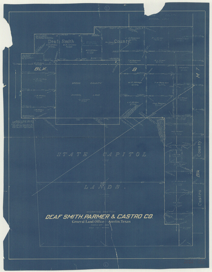
Deaf Smith County Working Sketch 2
Print $20.00
- Digital $50.00
Deaf Smith County Working Sketch 2
1926
Size 42.3 x 33.1 inches
Map/Doc 68642
[San Antonio & Aransas Pass]
![64211, [San Antonio & Aransas Pass], General Map Collection](https://historictexasmaps.com/wmedia_w700/maps/64211.tif.jpg)
Print $2.00
- Digital $50.00
[San Antonio & Aransas Pass]
Size 11.6 x 8.2 inches
Map/Doc 64211

Duval County Boundary File 1d

Print $40.00
- Digital $50.00
Duval County Boundary File 1d
Size 6.6 x 47.7 inches
Map/Doc 52699
Terrell County Rolled Sketch 49

Print $20.00
- Digital $50.00
Terrell County Rolled Sketch 49
1962
Size 17.3 x 24.1 inches
Map/Doc 7951
Burleson County Working Sketch 47

Print $20.00
- Digital $50.00
Burleson County Working Sketch 47
2010
Size 23.2 x 28.1 inches
Map/Doc 89620
You may also like
Irion County Sketch File 8

Print $6.00
- Digital $50.00
Irion County Sketch File 8
Size 14.5 x 9.8 inches
Map/Doc 27473
Briscoe County Sketch File 11

Print $9.00
- Digital $50.00
Briscoe County Sketch File 11
Size 11.8 x 11.0 inches
Map/Doc 16422
Flight Mission No. DQN-5K, Frame 146, Calhoun County

Print $20.00
- Digital $50.00
Flight Mission No. DQN-5K, Frame 146, Calhoun County
1953
Size 18.6 x 22.2 inches
Map/Doc 84421
Wood County Sketch File 13

Print $24.00
- Digital $50.00
Wood County Sketch File 13
1866
Size 12.5 x 7.6 inches
Map/Doc 40668
Sabine County Sketch File 7

Print $2.00
Sabine County Sketch File 7
1882
Size 8.6 x 12.7 inches
Map/Doc 35619
Upton County Working Sketch 41

Print $40.00
- Digital $50.00
Upton County Working Sketch 41
1960
Size 40.4 x 54.2 inches
Map/Doc 69537
Lampasas County Working Sketch 15

Print $20.00
- Digital $50.00
Lampasas County Working Sketch 15
1975
Size 28.5 x 23.8 inches
Map/Doc 70292
Reagan County Working Sketch 20

Print $40.00
- Digital $50.00
Reagan County Working Sketch 20
1954
Size 37.5 x 68.2 inches
Map/Doc 71862
Lamar County Sketch File 7

Print $4.00
- Digital $50.00
Lamar County Sketch File 7
1880
Size 9.0 x 6.9 inches
Map/Doc 29288
Val Verde County Working Sketch 23

Print $20.00
- Digital $50.00
Val Verde County Working Sketch 23
1932
Size 29.6 x 24.9 inches
Map/Doc 72158
Comanche County Sketch File 8

Print $4.00
- Digital $50.00
Comanche County Sketch File 8
1853
Size 13.1 x 8.2 inches
Map/Doc 19066
Brewster County Sketch File NS-15

Print $40.00
- Digital $50.00
Brewster County Sketch File NS-15
1977
Size 16.7 x 14.4 inches
Map/Doc 16298