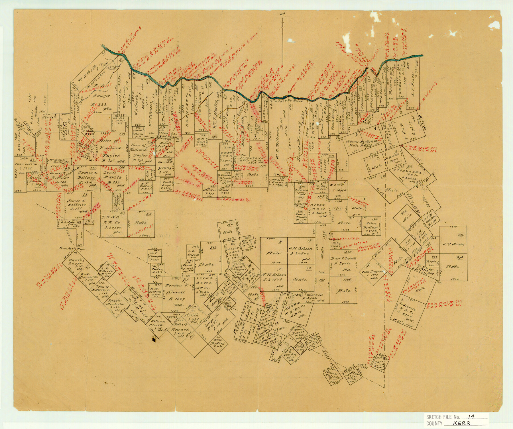
Kerr County Sketch File 14
Surveys in SE Corner, Kerr County, Texas
-
Map/Doc
11918
-
Collection
General Map Collection
-
Counties
Kerr Bandera Kendall
-
Subjects
Surveying Sketch File
-
Height x Width
14.9 x 17.8 inches
37.9 x 45.2 cm
-
Medium
paper, manuscript
-
Features
Guadalupe River
Bandera Pass
Part of: General Map Collection
Map of Jack County

Print $20.00
- Digital $50.00
Map of Jack County
1874
Size 20.7 x 17.6 inches
Map/Doc 3704
Location of the Southern Kansas Railway of Texas through Hemphill County, Texas

Print $40.00
- Digital $50.00
Location of the Southern Kansas Railway of Texas through Hemphill County, Texas
1887
Size 20.2 x 91.8 inches
Map/Doc 64000
Stephens County Sketch File 27

Print $6.00
- Digital $50.00
Stephens County Sketch File 27
Size 9.7 x 8.5 inches
Map/Doc 37101
Colorado County Working Sketch 2

Print $20.00
- Digital $50.00
Colorado County Working Sketch 2
1904
Size 28.8 x 30.1 inches
Map/Doc 68102
Winkler County Working Sketch 18

Print $40.00
- Digital $50.00
Winkler County Working Sketch 18
1980
Size 33.7 x 49.9 inches
Map/Doc 72612
Flight Mission No. DCL-7C, Frame 137, Kenedy County

Print $20.00
- Digital $50.00
Flight Mission No. DCL-7C, Frame 137, Kenedy County
1943
Size 15.4 x 15.3 inches
Map/Doc 86094
Flight Mission No. BQR-5K, Frame 66, Brazoria County

Print $20.00
- Digital $50.00
Flight Mission No. BQR-5K, Frame 66, Brazoria County
1952
Size 18.8 x 22.5 inches
Map/Doc 84011
Harris County Sketch File 73

Print $6.00
- Digital $50.00
Harris County Sketch File 73
1942
Size 11.3 x 8.9 inches
Map/Doc 25539
Cameron County

Print $20.00
- Digital $50.00
Cameron County
1913
Size 30.0 x 33.8 inches
Map/Doc 1793
Flight Mission No. BRE-2P, Frame 68, Nueces County

Print $20.00
- Digital $50.00
Flight Mission No. BRE-2P, Frame 68, Nueces County
1956
Size 18.6 x 22.4 inches
Map/Doc 86763
Northern Part of Laguna Madre

Print $20.00
- Digital $50.00
Northern Part of Laguna Madre
1949
Size 44.6 x 34.9 inches
Map/Doc 73524
Leon River, Leon River Sheet No. 1

Print $4.00
- Digital $50.00
Leon River, Leon River Sheet No. 1
1936
Size 29.2 x 19.8 inches
Map/Doc 65067
You may also like
Presidio County Sketch File 92

Print $10.00
- Digital $50.00
Presidio County Sketch File 92
1958
Size 11.2 x 8.8 inches
Map/Doc 34765
Parmer County

Print $20.00
- Digital $50.00
Parmer County
1926
Size 46.2 x 36.5 inches
Map/Doc 66973
Hopkins County Sketch File 23

Print $4.00
- Digital $50.00
Hopkins County Sketch File 23
1871
Size 12.6 x 8.4 inches
Map/Doc 26732
Flight Mission No. BRA-9M, Frame 67, Jefferson County

Print $20.00
- Digital $50.00
Flight Mission No. BRA-9M, Frame 67, Jefferson County
1953
Size 18.7 x 22.4 inches
Map/Doc 85650
Runnels County Working Sketch 36

Print $20.00
- Digital $50.00
Runnels County Working Sketch 36
1984
Size 31.9 x 39.2 inches
Map/Doc 63635
[T. & P. Blocks 33 and 34, Township 5N]
![90638, [T. & P. Blocks 33 and 34, Township 5N], Twichell Survey Records](https://historictexasmaps.com/wmedia_w700/maps/90638-1.tif.jpg)
Print $20.00
- Digital $50.00
[T. & P. Blocks 33 and 34, Township 5N]
Size 30.7 x 20.8 inches
Map/Doc 90638
[Sketch for Mineral Application 16700 - Pecos River Bed]
![2810, [Sketch for Mineral Application 16700 - Pecos River Bed], General Map Collection](https://historictexasmaps.com/wmedia_w700/maps/2810.tif.jpg)
Print $20.00
- Digital $50.00
[Sketch for Mineral Application 16700 - Pecos River Bed]
1927
Size 17.0 x 36.1 inches
Map/Doc 2810
Glasscock County Sketch File 6

Print $6.00
- Digital $50.00
Glasscock County Sketch File 6
1929
Size 14.8 x 10.9 inches
Map/Doc 24164
Brazoria County Sketch File 51

Print $380.00
- Digital $50.00
Brazoria County Sketch File 51
1926
Size 14.1 x 7.8 inches
Map/Doc 15125
[I. & G. N. Block 1, Runnels County School Land, T. C. Ry. Co. Block Z and G. C. & S. F. RR. Co. Block C-4]
![91661, [I. & G. N. Block 1, Runnels County School Land, T. C. Ry. Co. Block Z and G. C. & S. F. RR. Co. Block C-4], Twichell Survey Records](https://historictexasmaps.com/wmedia_w700/maps/91661-1.tif.jpg)
Print $20.00
- Digital $50.00
[I. & G. N. Block 1, Runnels County School Land, T. C. Ry. Co. Block Z and G. C. & S. F. RR. Co. Block C-4]
Size 29.7 x 17.9 inches
Map/Doc 91661
Railroad Track Map, H&TCRRCo., Falls County, Texas

Print $4.00
- Digital $50.00
Railroad Track Map, H&TCRRCo., Falls County, Texas
1918
Size 11.5 x 18.5 inches
Map/Doc 62856
Outer Continental Shelf Leasing Maps (Louisiana Offshore Operations)

Print $20.00
- Digital $50.00
Outer Continental Shelf Leasing Maps (Louisiana Offshore Operations)
1955
Size 16.2 x 13.0 inches
Map/Doc 76084