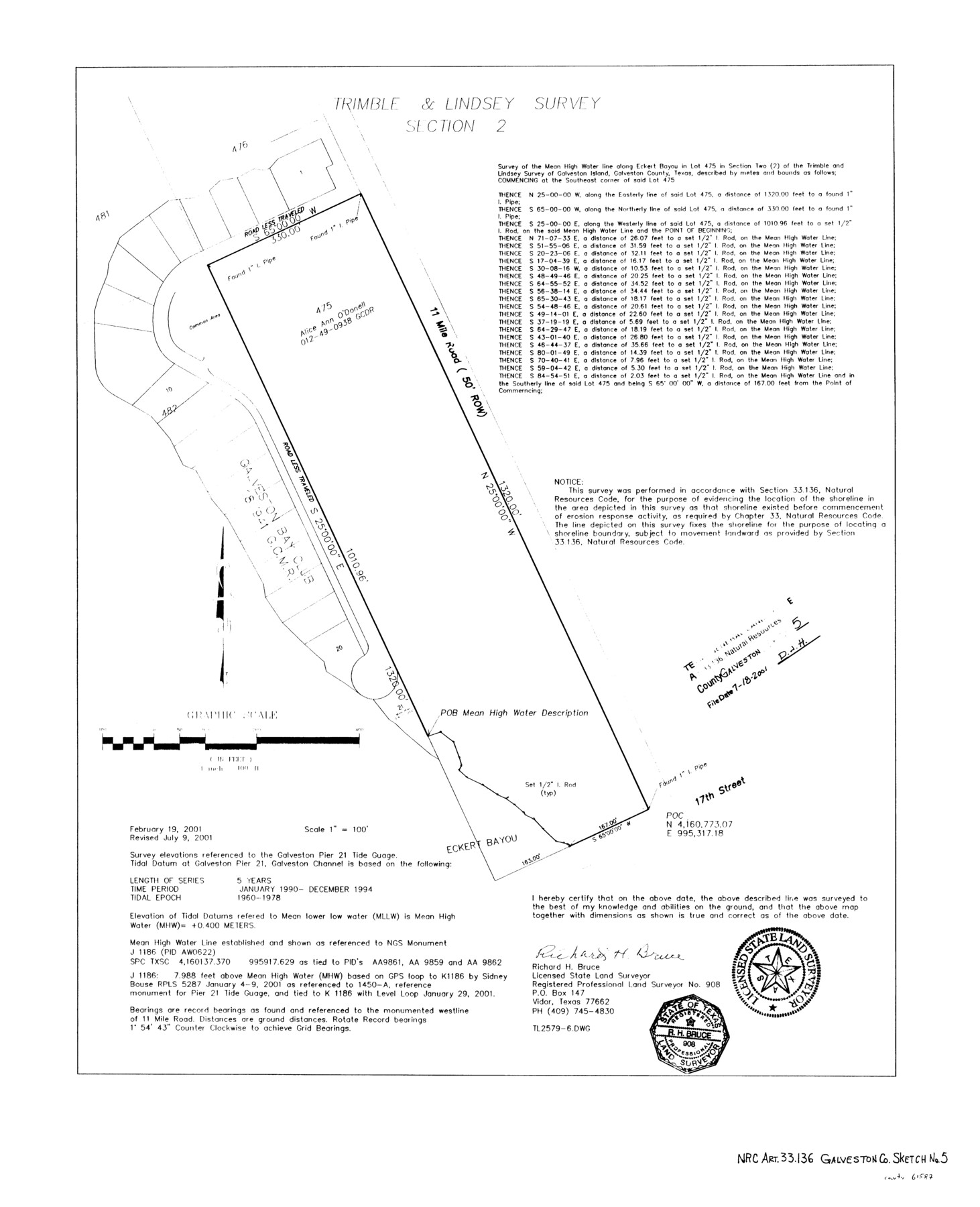
Galveston County NRC Article 33.136 Sketch 5
A Survey of the Mean High Water Line Along Eckert Bayou in Lot 475 in Section 2 of the Trimble and Lindsey Survey of Galveston Island
-
Map/Doc
61587
-
Collection
General Map Collection
-
Object Dates
2001/7/9 (Creation Date)
2001/7/18 (File Date)
-
People and Organizations
Richard H. Bruce, L.S.L.S. (Printer)
Richard H. Bruce (Surveyor/Engineer)
-
Counties
Galveston
-
Subjects
Surveying CBS
-
Height x Width
23.5 x 19.1 inches
59.7 x 48.5 cm
-
Medium
mylar, print
-
Comments
Survey located about 10 1/2 miles South 58 degrees West of Galveston, Texas.
Part of: General Map Collection
Wharton County Sketch File 17

Print $12.00
- Digital $50.00
Wharton County Sketch File 17
1898
Size 12.8 x 8.1 inches
Map/Doc 39969
Official Map of El Paso

Print $40.00
- Digital $50.00
Official Map of El Paso
1899
Size 53.9 x 60.3 inches
Map/Doc 2190
Bowie County Working Sketch 18

Print $20.00
- Digital $50.00
Bowie County Working Sketch 18
1962
Size 26.3 x 20.4 inches
Map/Doc 67422
A Topographical Map of the City of Austin

Print $20.00
- Digital $50.00
A Topographical Map of the City of Austin
1872
Size 21.0 x 14.7 inches
Map/Doc 4821
Flight Mission No. DAH-9M, Frame 164, Orange County

Print $20.00
- Digital $50.00
Flight Mission No. DAH-9M, Frame 164, Orange County
1953
Size 18.6 x 22.3 inches
Map/Doc 86863
Comanche County Sketch File 17

Print $14.00
- Digital $50.00
Comanche County Sketch File 17
Size 8.5 x 8.2 inches
Map/Doc 19086
Jefferson County Working Sketch 33

Print $20.00
- Digital $50.00
Jefferson County Working Sketch 33
1981
Size 18.8 x 15.4 inches
Map/Doc 66577
Fort Bend County Sketch File 5

Print $4.00
- Digital $50.00
Fort Bend County Sketch File 5
Size 8.2 x 13.0 inches
Map/Doc 22889
Crosby County Working Sketch 14

Print $20.00
- Digital $50.00
Crosby County Working Sketch 14
1976
Size 41.6 x 32.3 inches
Map/Doc 68448
Controlled Mosaic by Jack Amman Photogrammetric Engineers, Inc - Sheet 45

Print $20.00
- Digital $50.00
Controlled Mosaic by Jack Amman Photogrammetric Engineers, Inc - Sheet 45
1954
Size 20.0 x 24.0 inches
Map/Doc 83504
Webb County Sketch File A

Print $20.00
- Digital $50.00
Webb County Sketch File A
1891
Size 35.3 x 17.1 inches
Map/Doc 12603
Wise County Working Sketch 7

Print $20.00
- Digital $50.00
Wise County Working Sketch 7
1950
Size 26.2 x 24.8 inches
Map/Doc 72621
You may also like
Travis County Rolled Sketch 36

Print $20.00
- Digital $50.00
Travis County Rolled Sketch 36
Size 33.9 x 24.5 inches
Map/Doc 8037
Kleberg County Rolled Sketch 10-16

Print $20.00
- Digital $50.00
Kleberg County Rolled Sketch 10-16
1952
Size 37.0 x 33.2 inches
Map/Doc 9381
Brewster County Rolled Sketch 64
Print $20.00
- Digital $50.00
Brewster County Rolled Sketch 64
1940
Size 17.1 x 21.0 inches
Map/Doc 5232
Sterling County Sketch File A

Print $20.00
- Digital $50.00
Sterling County Sketch File A
1906
Size 18.2 x 26.0 inches
Map/Doc 12362
Red River County, Texas

Print $20.00
- Digital $50.00
Red River County, Texas
1879
Size 29.3 x 21.9 inches
Map/Doc 598
Harris County Working Sketch 57

Print $20.00
- Digital $50.00
Harris County Working Sketch 57
1951
Size 21.7 x 20.0 inches
Map/Doc 65949
Flight Mission No. BRA-6M, Frame 148, Jefferson County

Print $20.00
- Digital $50.00
Flight Mission No. BRA-6M, Frame 148, Jefferson County
1953
Size 18.5 x 22.4 inches
Map/Doc 85449
Mills County Working Sketch 18

Print $20.00
- Digital $50.00
Mills County Working Sketch 18
1963
Size 23.2 x 37.0 inches
Map/Doc 71048
Palo Pinto County Sketch File A

Print $6.00
- Digital $50.00
Palo Pinto County Sketch File A
Size 8.7 x 4.1 inches
Map/Doc 33389
Map of Fayette County Texas

Print $20.00
- Digital $50.00
Map of Fayette County Texas
1840
Size 26.4 x 22.6 inches
Map/Doc 3539
Culberson County Working Sketch 34

Print $20.00
- Digital $50.00
Culberson County Working Sketch 34
1962
Size 35.2 x 26.0 inches
Map/Doc 68487
Hardeman County Working Sketch 18

Print $20.00
- Digital $50.00
Hardeman County Working Sketch 18
2002
Size 33.5 x 36.5 inches
Map/Doc 76401