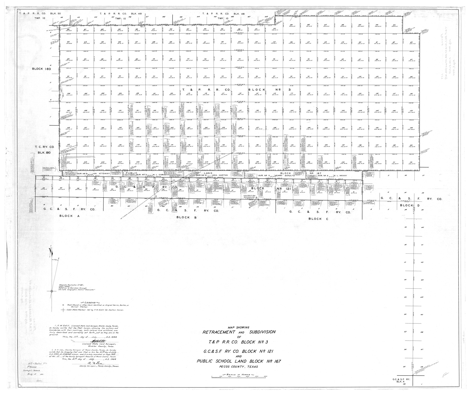
Pecos County Rolled Sketch 117
Map showing retracement and subdivision of T. & P. R.R. Co. Block no. 3, G. C. & S. F. Ry. Co. Block no. 121 and Public School Land Block no. 167
-
Map/Doc
9722
-
Collection
General Map Collection
-
Object Dates
1944/7/17 (Creation Date)
1944/8/5 (File Date)
-
People and Organizations
F.W. Estill (Surveyor/Engineer)
-
Counties
Pecos
-
Subjects
Surveying Rolled Sketch
-
Height x Width
44.6 x 52.6 inches
113.3 x 133.6 cm
Part of: General Map Collection
Flight Mission No. CRK-5P, Frame 123, Refugio County

Print $20.00
- Digital $50.00
Flight Mission No. CRK-5P, Frame 123, Refugio County
1956
Size 18.4 x 22.1 inches
Map/Doc 86926
Liberty County Working Sketch 77

Print $20.00
- Digital $50.00
Liberty County Working Sketch 77
Size 37.4 x 45.9 inches
Map/Doc 70537
Dallas County Boundary File 6

Print $10.00
- Digital $50.00
Dallas County Boundary File 6
Size 11.1 x 8.5 inches
Map/Doc 52184
Cooke County Sketch File 22

Print $6.00
- Digital $50.00
Cooke County Sketch File 22
1870
Size 6.4 x 8.2 inches
Map/Doc 19267
Flight Mission No. DAG-24K, Frame 150, Matagorda County

Print $20.00
- Digital $50.00
Flight Mission No. DAG-24K, Frame 150, Matagorda County
1953
Size 18.5 x 22.2 inches
Map/Doc 86564
Texas Gulf Coast Map from the Sabine River to the Rio Grande as subdivided for mineral development

Print $40.00
- Digital $50.00
Texas Gulf Coast Map from the Sabine River to the Rio Grande as subdivided for mineral development
1948
Size 60.9 x 36.7 inches
Map/Doc 2909
Harris County Sketch File 23

Print $4.00
- Digital $50.00
Harris County Sketch File 23
Size 8.5 x 6.2 inches
Map/Doc 25377
Culberson County Rolled Sketch 40

Print $20.00
- Digital $50.00
Culberson County Rolled Sketch 40
Size 32.1 x 25.0 inches
Map/Doc 8751
[Surveys along the Red River made for titles under Radford Berry, Commissioner]
![32, [Surveys along the Red River made for titles under Radford Berry, Commissioner], General Map Collection](https://historictexasmaps.com/wmedia_w700/maps/32.tif.jpg)
Print $20.00
- Digital $50.00
[Surveys along the Red River made for titles under Radford Berry, Commissioner]
Size 23.3 x 19.5 inches
Map/Doc 32
Polk County Working Sketch 23b

Print $40.00
- Digital $50.00
Polk County Working Sketch 23b
1957
Size 28.8 x 54.6 inches
Map/Doc 71639
El Paso County Boundary File 10

Print $14.00
- Digital $50.00
El Paso County Boundary File 10
Size 12.7 x 8.2 inches
Map/Doc 53118
Trinity County Sketch File 18 1/2

Print $4.00
- Digital $50.00
Trinity County Sketch File 18 1/2
1876
Size 9.0 x 11.2 inches
Map/Doc 38548
You may also like
Tom Green County Rolled Sketch 5

Print $20.00
- Digital $50.00
Tom Green County Rolled Sketch 5
1947
Size 44.9 x 35.0 inches
Map/Doc 9997
Bandera County Boundary File 6

Print $42.00
- Digital $50.00
Bandera County Boundary File 6
1972
Size 14.2 x 8.9 inches
Map/Doc 50303
Coke County Boundary File 6

Print $62.00
- Digital $50.00
Coke County Boundary File 6
Size 7.2 x 37.9 inches
Map/Doc 51615
Armstrong County Working Sketch 2

Print $20.00
- Digital $50.00
Armstrong County Working Sketch 2
1904
Size 29.0 x 23.4 inches
Map/Doc 67233
Stonewall County Working Sketch 9

Print $20.00
- Digital $50.00
Stonewall County Working Sketch 9
1950
Size 27.9 x 34.1 inches
Map/Doc 62316
Dimmit County Working Sketch 58

Print $20.00
- Digital $50.00
Dimmit County Working Sketch 58
2017
Size 24.2 x 36.2 inches
Map/Doc 94121
General Highway Map, Rains County, Wood County, Texas

Print $20.00
General Highway Map, Rains County, Wood County, Texas
1939
Size 18.2 x 24.8 inches
Map/Doc 79223
Map of Bexar County

Print $20.00
- Digital $50.00
Map of Bexar County
1878
Size 24.5 x 27.6 inches
Map/Doc 3298
Webb County Sketch File 9-1

Print $20.00
- Digital $50.00
Webb County Sketch File 9-1
1879
Size 15.8 x 15.7 inches
Map/Doc 12622
Zapata County Working Sketch 3

Print $20.00
- Digital $50.00
Zapata County Working Sketch 3
1932
Size 18.0 x 13.6 inches
Map/Doc 62054
Map of America

Print $20.00
- Digital $50.00
Map of America
1841
Size 21.6 x 24.9 inches
Map/Doc 95150
Kinney County Working Sketch 8

Print $20.00
- Digital $50.00
Kinney County Working Sketch 8
1913
Size 19.4 x 15.1 inches
Map/Doc 70190