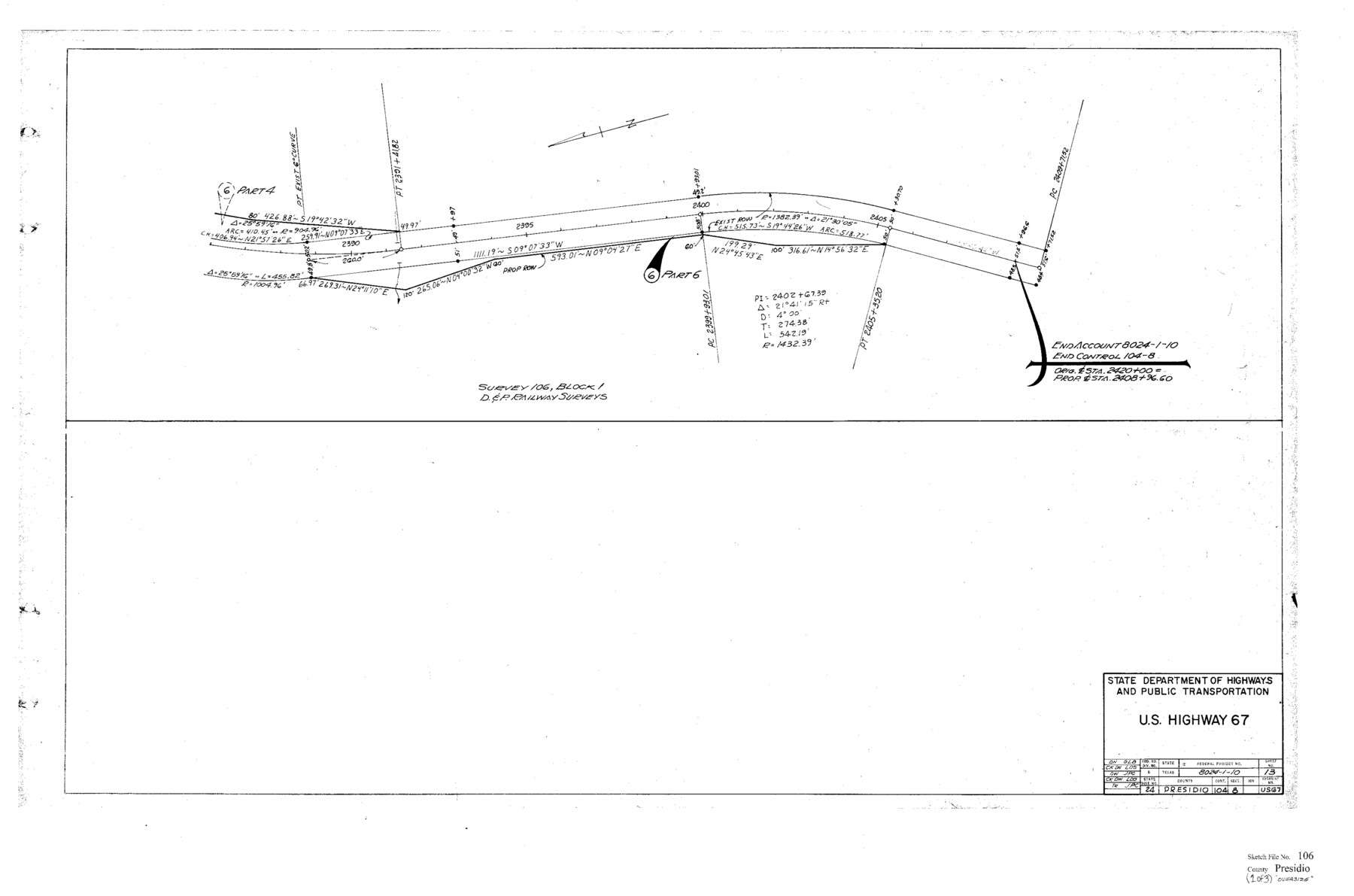
Presidio County Sketch File 106
U.S. Highway 67
-
Map/Doc
10580
-
Collection
General Map Collection
-
Object Dates
5/17/1983 (Creation Date)
12/21/1984 (File Date)
-
People and Organizations
L.E. Clarke (Surveyor/Engineer)
M.G. Goode (Surveyor/Engineer)
-
Counties
Presidio
-
Subjects
Surveying Sketch File
-
Height x Width
25.3 x 38.3 inches
64.3 x 97.3 cm
-
Medium
paper, print
Part of: General Map Collection
Baylor County

Print $20.00
- Digital $50.00
Baylor County
1961
Size 40.6 x 33.0 inches
Map/Doc 77209
Sutton County Sketch File 23

Print $30.00
- Digital $50.00
Sutton County Sketch File 23
1918
Size 14.2 x 8.5 inches
Map/Doc 37461
Hamilton County Sketch File 4

Print $16.00
- Digital $50.00
Hamilton County Sketch File 4
Size 14.5 x 9.1 inches
Map/Doc 24903
Newton County Sketch File 19

Print $20.00
- Digital $50.00
Newton County Sketch File 19
Size 22.8 x 9.4 inches
Map/Doc 42158
Atascosa County Working Sketch 25

Print $20.00
- Digital $50.00
Atascosa County Working Sketch 25
1958
Size 38.2 x 44.0 inches
Map/Doc 67221
Pecos County Boundary File 1

Print $2.00
- Digital $50.00
Pecos County Boundary File 1
Size 10.1 x 8.0 inches
Map/Doc 57854
Floyd County Boundary File 1a

Print $40.00
- Digital $50.00
Floyd County Boundary File 1a
Size 9.2 x 37.4 inches
Map/Doc 53460
Nueces County Sketch File 39

Print $8.00
- Digital $50.00
Nueces County Sketch File 39
1934
Size 11.0 x 8.5 inches
Map/Doc 32623
El Paso County Boundary File 27

Print $2.00
- Digital $50.00
El Paso County Boundary File 27
Size 7.3 x 5.6 inches
Map/Doc 53236
Flight Mission No. BRE-1P, Frame 93, Nueces County

Print $20.00
- Digital $50.00
Flight Mission No. BRE-1P, Frame 93, Nueces County
1956
Size 18.5 x 22.2 inches
Map/Doc 86664
Layout of the porciones as described in the Visita General of Revilla (Guerrero), 1767, along with six tracts distributed by Gov. Lasaga in 1784 and three others (39-41) assigned at a later date

Layout of the porciones as described in the Visita General of Revilla (Guerrero), 1767, along with six tracts distributed by Gov. Lasaga in 1784 and three others (39-41) assigned at a later date
2009
Size 11.0 x 8.5 inches
Map/Doc 94044
Val Verde County Rolled Sketch 10

Print $20.00
- Digital $50.00
Val Verde County Rolled Sketch 10
Size 22.9 x 27.8 inches
Map/Doc 8108
You may also like
No. 1 - Survey for a road from the Brazo Santiago to the Rio Grande

Print $20.00
- Digital $50.00
No. 1 - Survey for a road from the Brazo Santiago to the Rio Grande
1847
Size 18.4 x 27.3 inches
Map/Doc 72875
Crane County Sketch File 26

Print $10.00
- Digital $50.00
Crane County Sketch File 26
1939
Size 11.5 x 9.0 inches
Map/Doc 19598
[Brooks & Burleson Blocks 2 and 4, Capitol Leagues and other surveys and Blocks in vicinity]
![90645, [Brooks & Burleson Blocks 2 and 4, Capitol Leagues and other surveys and Blocks in vicinity], Twichell Survey Records](https://historictexasmaps.com/wmedia_w700/maps/90645-1.tif.jpg)
Print $20.00
- Digital $50.00
[Brooks & Burleson Blocks 2 and 4, Capitol Leagues and other surveys and Blocks in vicinity]
1903
Size 22.6 x 35.6 inches
Map/Doc 90645
Gulf of Mexico

Print $20.00
- Digital $50.00
Gulf of Mexico
1900
Size 18.2 x 28.0 inches
Map/Doc 72648
Brewster County Rolled Sketch 128

Print $20.00
- Digital $50.00
Brewster County Rolled Sketch 128
1978
Size 24.9 x 28.0 inches
Map/Doc 5300
Webb County Sketch File 7-2

Print $20.00
- Digital $50.00
Webb County Sketch File 7-2
1927
Size 31.6 x 23.7 inches
Map/Doc 12618
Cameron County

Print $20.00
- Digital $50.00
Cameron County
1913
Size 29.3 x 33.6 inches
Map/Doc 4902
Nacogdoches County Boundary File 1

Print $36.00
- Digital $50.00
Nacogdoches County Boundary File 1
Size 6.7 x 4.4 inches
Map/Doc 57562
Harris County Sketch File 107

Print $18.00
- Digital $50.00
Harris County Sketch File 107
1996
Size 11.2 x 8.7 inches
Map/Doc 26015
Concho County Rolled Sketch 24

Print $20.00
- Digital $50.00
Concho County Rolled Sketch 24
1964
Size 27.5 x 36.9 inches
Map/Doc 5557
Pecos County Sketch File 83

Print $6.00
- Digital $50.00
Pecos County Sketch File 83
1884
Size 11.3 x 8.7 inches
Map/Doc 33950
Sutton County Sketch File E2

Print $20.00
- Digital $50.00
Sutton County Sketch File E2
Size 16.8 x 19.0 inches
Map/Doc 12397