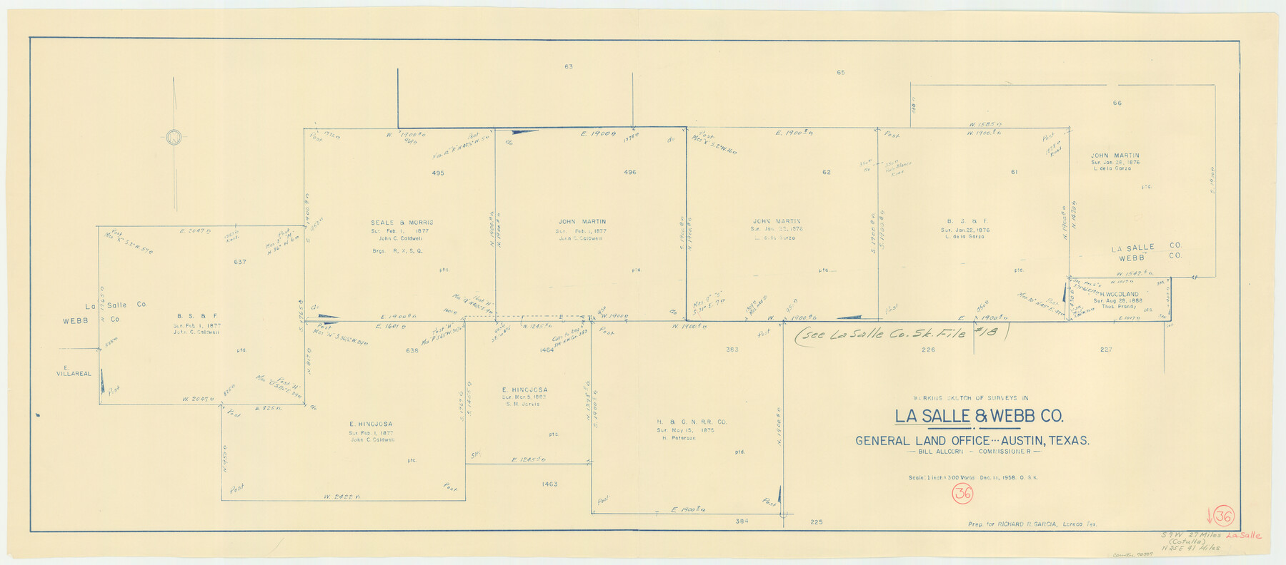
La Salle County Working Sketch 36
-
Map/Doc
70337
-
Collection
General Map Collection
-
Object Dates
12/11/1958 (Creation Date)
-
People and Organizations
Otto G. Kurio (Draftsman)
-
Counties
La Salle Webb
-
Subjects
Surveying Working Sketch
-
Height x Width
18.8 x 42.6 inches
47.8 x 108.2 cm
-
Scale
1" = 300 varas
-
Comments
See La Salle County Sketch File 18 (29507)
Related maps
La Salle County Sketch File 18

Print $4.00
- Digital $50.00
La Salle County Sketch File 18
1885
Size 8.5 x 15.5 inches
Map/Doc 29507
Part of: General Map Collection
Dimmit County Working Sketch 56

Print $20.00
- Digital $50.00
Dimmit County Working Sketch 56
1990
Size 23.0 x 29.0 inches
Map/Doc 68717
Edwards County Sketch File 48

Print $6.00
- Digital $50.00
Edwards County Sketch File 48
1955
Size 9.7 x 7.6 inches
Map/Doc 21797
Frio County Sketch File 17

Print $6.00
- Digital $50.00
Frio County Sketch File 17
1955
Size 14.3 x 8.7 inches
Map/Doc 23152
[Sketch for Mineral Application 13439 - Old River, Walle Merritt]
![65689, [Sketch for Mineral Application 13439 - Old River, Walle Merritt], General Map Collection](https://historictexasmaps.com/wmedia_w700/maps/65689-1.tif.jpg)
Print $20.00
- Digital $50.00
[Sketch for Mineral Application 13439 - Old River, Walle Merritt]
1925
Size 41.0 x 19.0 inches
Map/Doc 65689
West Part of Liberty Co.

Print $20.00
- Digital $50.00
West Part of Liberty Co.
1977
Size 46.2 x 35.5 inches
Map/Doc 73220
Amistad International Reservoir on Rio Grande 62

Print $20.00
- Digital $50.00
Amistad International Reservoir on Rio Grande 62
1949
Size 28.2 x 39.6 inches
Map/Doc 73347
Frio County Sketch File 14

Print $8.00
- Digital $50.00
Frio County Sketch File 14
1949
Size 11.2 x 8.7 inches
Map/Doc 23141
Index for Texas Railroad ROW & track maps available on microfilm at THD & Archives and Records

Print $2.00
- Digital $50.00
Index for Texas Railroad ROW & track maps available on microfilm at THD & Archives and Records
1977
Size 11.1 x 8.6 inches
Map/Doc 60763
Map of Colorado County

Print $20.00
- Digital $50.00
Map of Colorado County
1881
Size 22.5 x 21.4 inches
Map/Doc 3427
Hemphill County Rolled Sketch 18

Print $20.00
- Digital $50.00
Hemphill County Rolled Sketch 18
Size 23.6 x 35.0 inches
Map/Doc 6200
Flight Mission No. DQN-5K, Frame 145, Calhoun County

Print $20.00
- Digital $50.00
Flight Mission No. DQN-5K, Frame 145, Calhoun County
1953
Size 18.5 x 22.1 inches
Map/Doc 84420
Orange County Rolled Sketch 13

Print $20.00
- Digital $50.00
Orange County Rolled Sketch 13
Size 19.0 x 24.2 inches
Map/Doc 7180
You may also like
Travis County Working Sketch 36

Print $20.00
- Digital $50.00
Travis County Working Sketch 36
1967
Size 23.4 x 30.8 inches
Map/Doc 69420
East Part of Liberty Co.

Print $20.00
- Digital $50.00
East Part of Liberty Co.
1977
Size 47.9 x 36.9 inches
Map/Doc 95569
Foard County Boundary File 4a

Print $40.00
- Digital $50.00
Foard County Boundary File 4a
Size 16.9 x 45.4 inches
Map/Doc 53522
Freestone County

Print $40.00
- Digital $50.00
Freestone County
1918
Size 48.9 x 42.0 inches
Map/Doc 1831
Jefferson County NRC Article 33.136 Location Key Sheet

Print $20.00
- Digital $50.00
Jefferson County NRC Article 33.136 Location Key Sheet
1993
Size 27.0 x 21.8 inches
Map/Doc 77030
Smith County Working Sketch 8

Print $20.00
- Digital $50.00
Smith County Working Sketch 8
1941
Size 28.9 x 22.7 inches
Map/Doc 63893
Moore County Working Sketch 14

Print $20.00
- Digital $50.00
Moore County Working Sketch 14
1972
Size 32.7 x 19.8 inches
Map/Doc 71196
Liberty County Rolled Sketch P

Print $33.00
- Digital $50.00
Liberty County Rolled Sketch P
Size 10.3 x 16.5 inches
Map/Doc 46545
Flight Mission No. DQO-3K, Frame 25, Galveston County

Print $20.00
- Digital $50.00
Flight Mission No. DQO-3K, Frame 25, Galveston County
1952
Size 18.8 x 22.4 inches
Map/Doc 85066
Copy of a portion of Arista's map

Print $20.00
- Digital $50.00
Copy of a portion of Arista's map
1847
Size 27.5 x 18.3 inches
Map/Doc 73057
Glasscock County Rolled Sketch 17

Print $20.00
- Digital $50.00
Glasscock County Rolled Sketch 17
Size 21.6 x 27.4 inches
Map/Doc 6021
Dimmit County Rolled Sketch 23

Print $20.00
- Digital $50.00
Dimmit County Rolled Sketch 23
2015
Size 18.1 x 24.3 inches
Map/Doc 93792