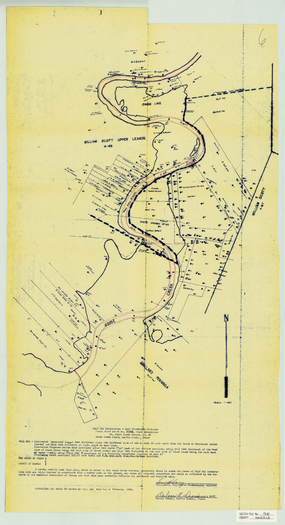
Harris County Sketch File 95
Goose Cr. Well Locations - Well #15
-
Map/Doc
11678
-
Collection
General Map Collection
-
Object Dates
1952/2/22 (Creation Date)
1987/12/7 (File Date)
-
People and Organizations
George H. Lacy (Surveyor/Engineer)
-
Counties
Harris
-
Subjects
Surveying Sketch File
-
Height x Width
31.6 x 17.1 inches
80.3 x 43.4 cm
-
Medium
blueprint/diazo
-
Scale
1:300
-
Features
Baytown
Goose Lake
State Highway 146
Goose Creek
Gaillard Peninsula
Part of: General Map Collection
Flight Mission No. DQN-7K, Frame 16, Calhoun County

Print $20.00
- Digital $50.00
Flight Mission No. DQN-7K, Frame 16, Calhoun County
1953
Size 18.5 x 22.1 inches
Map/Doc 84467
Matagorda County Sketch File 31

Print $4.00
- Digital $50.00
Matagorda County Sketch File 31
1919
Size 11.4 x 8.2 inches
Map/Doc 30815
Baylor County Sketch File 7

Print $4.00
- Digital $50.00
Baylor County Sketch File 7
Size 6.7 x 10.2 inches
Map/Doc 14135
Flight Mission No. CLL-3N, Frame 3, Willacy County

Print $20.00
- Digital $50.00
Flight Mission No. CLL-3N, Frame 3, Willacy County
1954
Size 18.6 x 22.3 inches
Map/Doc 87069
Dickens County Sketch File 18aa

Print $20.00
- Digital $50.00
Dickens County Sketch File 18aa
Size 17.2 x 18.2 inches
Map/Doc 11323
Township 5 North Range 13 West, North Western District, Louisiana

Print $20.00
- Digital $50.00
Township 5 North Range 13 West, North Western District, Louisiana
1885
Size 19.8 x 24.7 inches
Map/Doc 65865
Bandera County Working Sketch 11

Print $20.00
- Digital $50.00
Bandera County Working Sketch 11
1928
Size 17.8 x 27.4 inches
Map/Doc 67604
Harrison County Sketch File 5

Print $4.00
- Digital $50.00
Harrison County Sketch File 5
1857
Size 8.1 x 9.9 inches
Map/Doc 26042
Dimmit County Sketch File 34

Print $4.00
- Digital $50.00
Dimmit County Sketch File 34
1884
Size 9.0 x 8.7 inches
Map/Doc 21153
Right of Way and Track Map Houston & Texas Central R.R. operated by the T. and N. O. R.R. Co., Fort Worth Branch

Print $40.00
- Digital $50.00
Right of Way and Track Map Houston & Texas Central R.R. operated by the T. and N. O. R.R. Co., Fort Worth Branch
1918
Size 31.4 x 58.5 inches
Map/Doc 64544
Colorado County Boundary File 1

Print $8.00
- Digital $50.00
Colorado County Boundary File 1
Size 14.0 x 8.6 inches
Map/Doc 51768
Guadalupe County

Print $20.00
- Digital $50.00
Guadalupe County
1977
Size 35.9 x 46.4 inches
Map/Doc 73165
You may also like
Uvalde County Working Sketch 11

Print $20.00
- Digital $50.00
Uvalde County Working Sketch 11
1943
Size 17.6 x 16.6 inches
Map/Doc 72081
Dawson County, Texas

Print $20.00
- Digital $50.00
Dawson County, Texas
Size 16.0 x 18.1 inches
Map/Doc 92620
Denton County Sketch File 14

Print $10.00
- Digital $50.00
Denton County Sketch File 14
1855
Size 8.6 x 10.0 inches
Map/Doc 20719
Yoakum County Sketch File 4

Print $30.00
- Digital $50.00
Yoakum County Sketch File 4
Size 8.0 x 7.8 inches
Map/Doc 40718
[Right of Way Map, Belton Branch of the M.K.&T. RR.]
![64715, [Right of Way Map, Belton Branch of the M.K.&T. RR.], General Map Collection](https://historictexasmaps.com/wmedia_w700/maps/64715-1.tif.jpg)
Print $2.00
- Digital $50.00
[Right of Way Map, Belton Branch of the M.K.&T. RR.]
1896
Size 11.1 x 8.3 inches
Map/Doc 64715
DeWitt County Working Sketch 3

Print $20.00
- Digital $50.00
DeWitt County Working Sketch 3
1957
Size 35.5 x 44.6 inches
Map/Doc 68593
Coleman County Working Sketch 12

Print $20.00
- Digital $50.00
Coleman County Working Sketch 12
1951
Size 25.7 x 26.2 inches
Map/Doc 68078
Coast Chart No. 210 - Aransas Pass and Corpus Christi Bay with the coast to latitude 27° 12', Texas

Print $20.00
- Digital $50.00
Coast Chart No. 210 - Aransas Pass and Corpus Christi Bay with the coast to latitude 27° 12', Texas
1907
Size 18.4 x 24.2 inches
Map/Doc 73450
Crockett County Sketch File 79

Print $18.00
- Digital $50.00
Crockett County Sketch File 79
1937
Size 11.1 x 8.8 inches
Map/Doc 19881
Tom Green County Sketch File 41

Print $8.00
- Digital $50.00
Tom Green County Sketch File 41
1884
Size 12.8 x 8.3 inches
Map/Doc 38196
Survey of The Rio Grande Roma to the Gulf of Mexico

Survey of The Rio Grande Roma to the Gulf of Mexico
Map/Doc 81739
[Leagues 139 and 130]
![90440, [Leagues 139 and 130], Twichell Survey Records](https://historictexasmaps.com/wmedia_w700/maps/90440-1.tif.jpg)
Print $2.00
- Digital $50.00
[Leagues 139 and 130]
Size 7.9 x 12.5 inches
Map/Doc 90440