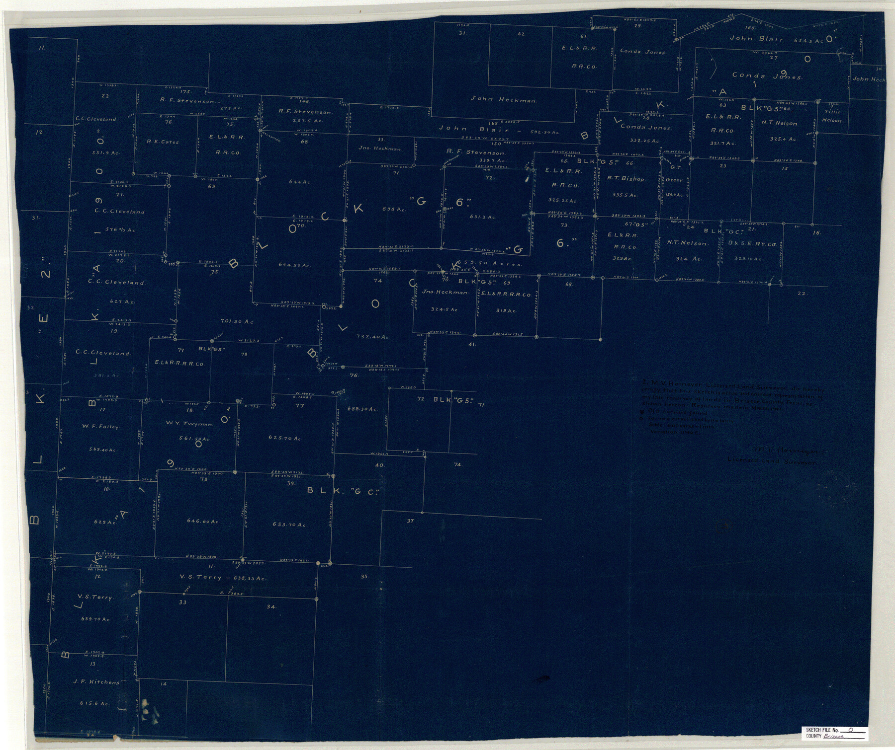
Briscoe County Sketch File O
[Sketch of parts of Blocks G6 and A-1900 in northeast part of county]
-
Map/Doc
11013
-
Collection
General Map Collection
-
Object Dates
1921/8/10 (File Date)
1921 (Survey Date)
-
People and Organizations
M.V. Homeyer (Surveyor/Engineer)
-
Counties
Briscoe
-
Subjects
Surveying Sketch File
-
Height x Width
27.1 x 32.4 inches
68.8 x 82.3 cm
-
Medium
blueprint/diazo
-
Scale
1" = 600 varas
Part of: General Map Collection
Working Sketch Patents & Field Notes, Sabine Lake Area

Print $20.00
- Digital $50.00
Working Sketch Patents & Field Notes, Sabine Lake Area
1959
Size 30.2 x 27.0 inches
Map/Doc 2455
Val Verde County Rolled Sketch 78

Print $20.00
- Digital $50.00
Val Verde County Rolled Sketch 78
1981
Size 42.9 x 29.6 inches
Map/Doc 8140
Flight Mission No. DQN-3K, Frame 68, Calhoun County

Print $20.00
- Digital $50.00
Flight Mission No. DQN-3K, Frame 68, Calhoun County
1953
Size 18.5 x 22.3 inches
Map/Doc 84359
Culberson County Working Sketch 34

Print $20.00
- Digital $50.00
Culberson County Working Sketch 34
1962
Size 35.2 x 26.0 inches
Map/Doc 68487
Surveyor's Watercourse Report 2

Print $42.00
Surveyor's Watercourse Report 2
2025
Size 11.0 x 8.5 inches
Map/Doc 97512
Americae Nova Descriptio

Print $20.00
- Digital $50.00
Americae Nova Descriptio
1663
Size 14.5 x 18.0 inches
Map/Doc 95708
Clay County Rolled Sketch 4A

Print $20.00
- Digital $50.00
Clay County Rolled Sketch 4A
1949
Size 22.0 x 24.0 inches
Map/Doc 5498
Donley County Sketch File 9

Print $4.00
- Digital $50.00
Donley County Sketch File 9
1884
Size 6.6 x 7.7 inches
Map/Doc 21238
Dallas County Rolled Sketch 6

Print $20.00
- Digital $50.00
Dallas County Rolled Sketch 6
1983
Size 31.7 x 37.5 inches
Map/Doc 8769
Map of North America to illustrate Olney's school geography

Print $20.00
- Digital $50.00
Map of North America to illustrate Olney's school geography
1844
Size 12.1 x 9.3 inches
Map/Doc 93536
Montgomery County Rolled Sketch 44

Print $20.00
- Digital $50.00
Montgomery County Rolled Sketch 44
2004
Size 24.5 x 18.1 inches
Map/Doc 82451
Presidio County Sketch File 35B

Print $20.00
- Digital $50.00
Presidio County Sketch File 35B
1906
Size 11.8 x 20.7 inches
Map/Doc 11714
You may also like
Liberty County Boundary File 2

Print $9.00
- Digital $50.00
Liberty County Boundary File 2
Size 17.0 x 11.0 inches
Map/Doc 56293
S. M. S. Throckmorton Ranch, Throckmorton, Haskell, Baylor Cos.

Print $20.00
- Digital $50.00
S. M. S. Throckmorton Ranch, Throckmorton, Haskell, Baylor Cos.
1955
Size 33.8 x 45.1 inches
Map/Doc 2104
Van Zandt County Working Sketch 18

Print $20.00
- Digital $50.00
Van Zandt County Working Sketch 18
Size 12.5 x 18.2 inches
Map/Doc 72268
Flight Mission No. BRA-8M, Frame 69, Jefferson County

Print $20.00
- Digital $50.00
Flight Mission No. BRA-8M, Frame 69, Jefferson County
1953
Size 18.6 x 22.1 inches
Map/Doc 85589
Uvalde County Working Sketch 43

Print $20.00
- Digital $50.00
Uvalde County Working Sketch 43
1978
Size 29.3 x 27.7 inches
Map/Doc 72113
Sketch in NE Portion Hutchinson County

Print $20.00
- Digital $50.00
Sketch in NE Portion Hutchinson County
1913
Size 36.9 x 43.3 inches
Map/Doc 75815

[Right of Way and Track Map, the Missouri, Kansas and Texas Ry. of Texas - Henrietta Division]
![64760, [Right of Way and Track Map, the Missouri, Kansas and Texas Ry. of Texas - Henrietta Division], General Map Collection](https://historictexasmaps.com/wmedia_w700/maps/64760.tif.jpg)
Print $20.00
- Digital $50.00
[Right of Way and Track Map, the Missouri, Kansas and Texas Ry. of Texas - Henrietta Division]
1918
Size 11.8 x 26.9 inches
Map/Doc 64760
Map of Jack County

Print $20.00
- Digital $50.00
Map of Jack County
1868
Size 23.8 x 19.8 inches
Map/Doc 3701
Nueces Bay and Adjoining Areas showing submerged Lands

Print $40.00
- Digital $50.00
Nueces Bay and Adjoining Areas showing submerged Lands
1946
Size 34.6 x 56.4 inches
Map/Doc 1916
Cass County Rolled Sketch 1

Print $20.00
- Digital $50.00
Cass County Rolled Sketch 1
1945
Size 22.1 x 23.7 inches
Map/Doc 5408
Dimmit County Working Sketch 48

Print $40.00
- Digital $50.00
Dimmit County Working Sketch 48
1980
Size 78.7 x 43.7 inches
Map/Doc 68709