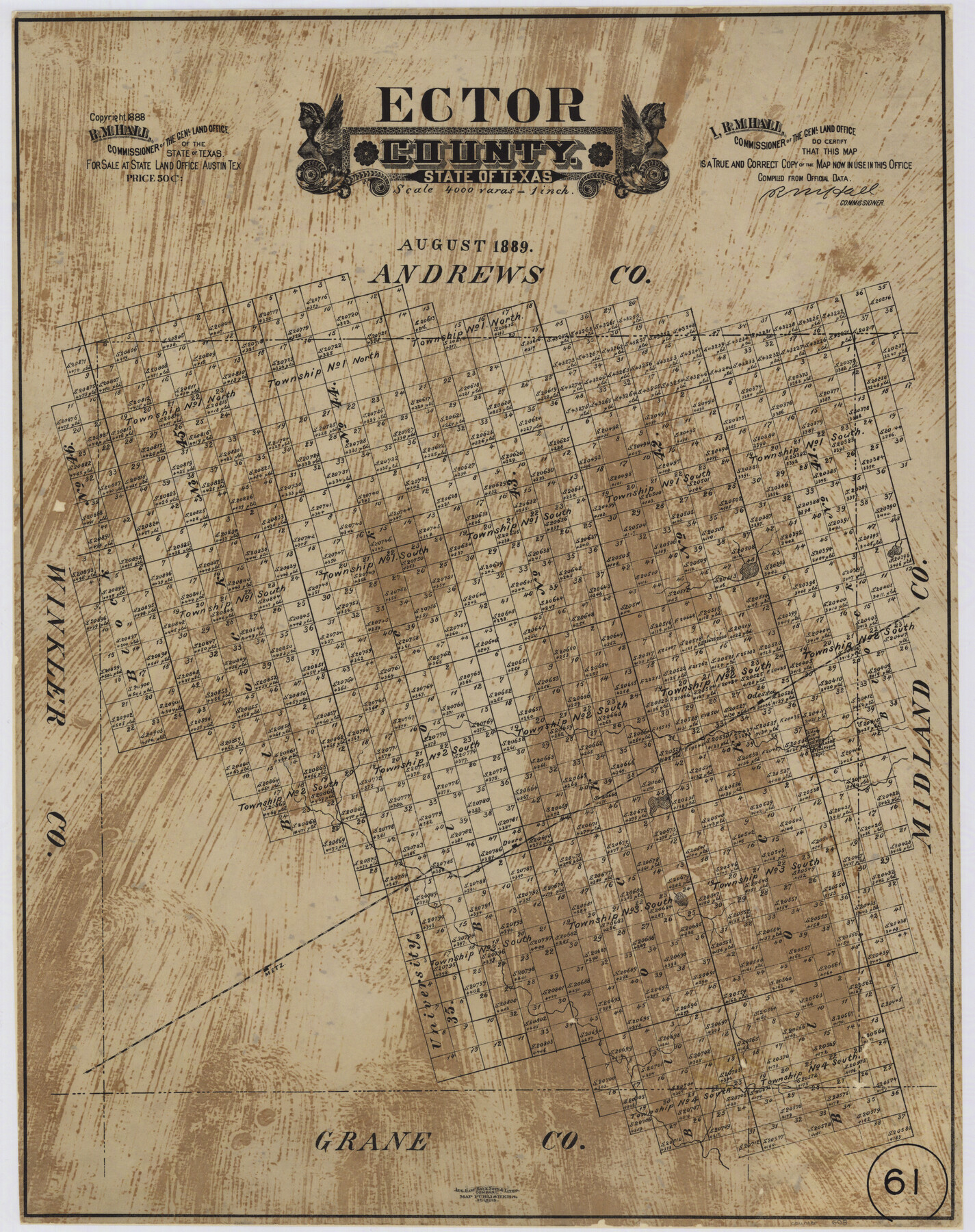
Ector County, Texas
-
Map/Doc
608
-
Collection
Maddox Collection
-
Object Dates
1889 (Creation Date)
1888 (Copyright Date)
-
People and Organizations
General Land Office (Publisher)
R.M. Hall (GLO Commissioner)
August Gast Bank Note & Lithograph Company (Lithographer)
-
Counties
Ector
-
Subjects
County
-
Height x Width
23.9 x 19.4 inches
60.7 x 49.3 cm
-
Medium
paper, etching/engraving/lithograph
-
Scale
1:4000
-
Comments
Conservation funded in 2002 with donation from Heritage of Odessa Foundation
-
Features
Odessa
Douro
Metz
Part of: Maddox Collection
[Unknown Building Sketch]
![75794, [Unknown Building Sketch], Maddox Collection](https://historictexasmaps.com/wmedia_w700/maps/75794.tif.jpg)
Print $20.00
- Digital $50.00
[Unknown Building Sketch]
Size 17.1 x 22.6 inches
Map/Doc 75794
[Dennis Corwin's Map of Survey for R. N. Graham]
![83427, [Dennis Corwin's Map of Survey for R. N. Graham], Maddox Collection](https://historictexasmaps.com/wmedia_w700/maps/83427.tif.jpg)
Print $2.00
- Digital $50.00
[Dennis Corwin's Map of Survey for R. N. Graham]
Size 11.1 x 8.5 inches
Map/Doc 83427
Sketch in NE Portion Hutchinson County

Print $20.00
- Digital $50.00
Sketch in NE Portion Hutchinson County
1913
Size 36.9 x 43.3 inches
Map/Doc 75815
Map of Clay County, Texas

Print $20.00
- Digital $50.00
Map of Clay County, Texas
1880
Size 33.0 x 23.2 inches
Map/Doc 699
Map of surveys 191 & 192 T. C. R.R. Co. in Travis County, Texas

Print $20.00
- Digital $50.00
Map of surveys 191 & 192 T. C. R.R. Co. in Travis County, Texas
1915
Size 20.6 x 13.5 inches
Map/Doc 75556
Midland County, Texas

Print $20.00
- Digital $50.00
Midland County, Texas
1880
Size 25.5 x 21.5 inches
Map/Doc 740
[Surveying Sketch of Loma Blanca, Santa Rosa, San Antonio del Encinal, et al]
![4449, [Surveying Sketch of Loma Blanca, Santa Rosa, San Antonio del Encinal, et al], Maddox Collection](https://historictexasmaps.com/wmedia_w700/maps/4449.tif.jpg)
Print $20.00
- Digital $50.00
[Surveying Sketch of Loma Blanca, Santa Rosa, San Antonio del Encinal, et al]
Size 19.0 x 22.1 inches
Map/Doc 4449
Map of Bowie County, Texas

Print $20.00
- Digital $50.00
Map of Bowie County, Texas
1879
Size 21.2 x 24.4 inches
Map/Doc 607
Map of Callahan County, Texas

Print $20.00
- Digital $50.00
Map of Callahan County, Texas
1879
Size 24.6 x 19.6 inches
Map/Doc 4337
[Northern Portion of] Cottle County
![4436, [Northern Portion of] Cottle County, Maddox Collection](https://historictexasmaps.com/wmedia_w700/maps/4436.tif.jpg)
Print $20.00
- Digital $50.00
[Northern Portion of] Cottle County
1908
Size 28.4 x 29.5 inches
Map/Doc 4436
College Heights a Subdivision of Outlots 8-9 and 62, Division B, Austin, Texas

Print $20.00
- Digital $50.00
College Heights a Subdivision of Outlots 8-9 and 62, Division B, Austin, Texas
Size 18.5 x 14.9 inches
Map/Doc 83429
Map of Llano County, Texas

Print $20.00
- Digital $50.00
Map of Llano County, Texas
1879
Size 24.6 x 22.9 inches
Map/Doc 568
You may also like
Hamilton County Sketch File 24

Print $20.00
- Digital $50.00
Hamilton County Sketch File 24
1953
Size 23.2 x 22.8 inches
Map/Doc 11619
Kerr County Working Sketch 17

Print $20.00
- Digital $50.00
Kerr County Working Sketch 17
1956
Size 20.0 x 23.7 inches
Map/Doc 70048
Gulf of Mexico

Print $20.00
- Digital $50.00
Gulf of Mexico
1908
Size 18.3 x 27.1 inches
Map/Doc 72656
[Connecting lines through Blocks A2, 29, I, GG, I. & G. N. Block 1 and Archer County School Land]
![91645, [Connecting lines through Blocks A2, 29, I, GG, I. & G. N. Block 1 and Archer County School Land], Twichell Survey Records](https://historictexasmaps.com/wmedia_w700/maps/91645-1.tif.jpg)
Print $20.00
- Digital $50.00
[Connecting lines through Blocks A2, 29, I, GG, I. & G. N. Block 1 and Archer County School Land]
Size 22.4 x 16.9 inches
Map/Doc 91645
Milam County Boundary File 3

Print $16.00
- Digital $50.00
Milam County Boundary File 3
Size 13.9 x 8.5 inches
Map/Doc 57213
Cameron County Rolled Sketch 20D

Print $20.00
- Digital $50.00
Cameron County Rolled Sketch 20D
Size 13.7 x 12.1 inches
Map/Doc 5476
Briscoe County Sketch File F

Print $40.00
- Digital $50.00
Briscoe County Sketch File F
1917
Size 20.9 x 19.3 inches
Map/Doc 76756
Caldwell County

Print $20.00
- Digital $50.00
Caldwell County
1896
Size 42.7 x 33.3 inches
Map/Doc 93039
Presidio County Rolled Sketch 66

Print $20.00
- Digital $50.00
Presidio County Rolled Sketch 66
1920
Size 19.4 x 37.5 inches
Map/Doc 7357
[Portion of Thomas Kelly Subdivision in Parmer and Castro Counties, Texas]
![92550, [Portion of Thomas Kelly Subdivision in Parmer and Castro Counties, Texas], Twichell Survey Records](https://historictexasmaps.com/wmedia_w700/maps/92550-1.tif.jpg)
Print $20.00
- Digital $50.00
[Portion of Thomas Kelly Subdivision in Parmer and Castro Counties, Texas]
1906
Size 20.3 x 16.4 inches
Map/Doc 92550

General Highway Map, Potter County, Texas

Print $20.00
General Highway Map, Potter County, Texas
1940
Size 24.6 x 18.3 inches
Map/Doc 79220