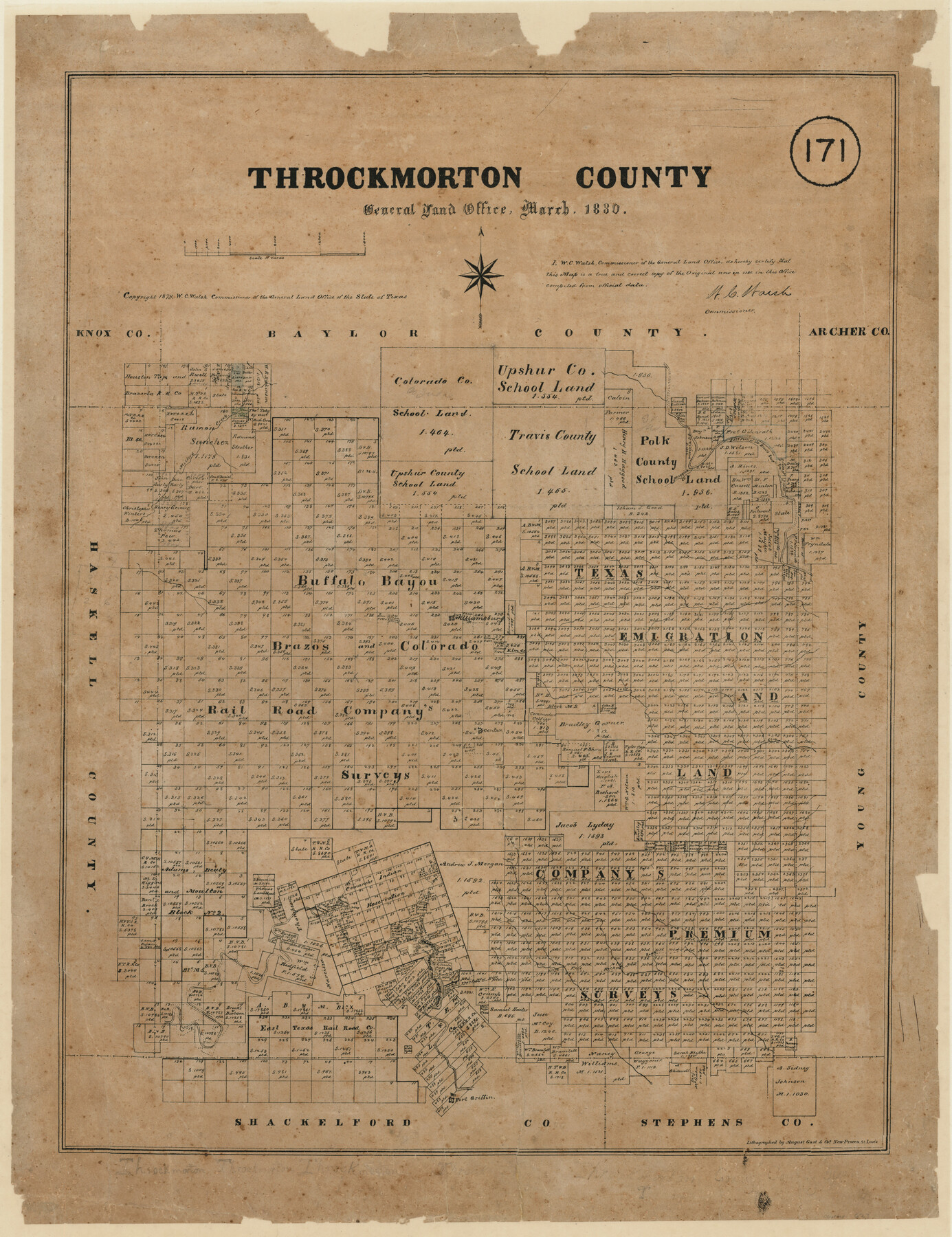
Throckmorton County, Texas
- 
                          Map/Doc
627
 - 
                            Collection
Maddox Collection
 - 
                            Object Dates
3/1880 (Creation Date)
1879 (Copyright Date)
 - 
                            People and Organizations
General Land Office (Publisher)
W.C. Walsh (GLO Commissioner)
August Gast & Co. (Lithographer)
 - 
                            Counties
Throckmorton
 - 
                            Subjects
County
 - 
                            Height x Width
28.8 x 22.5 inches
73.2 x 57.2 cm
 - 
                            Medium
paper, etching/engraving/lithograph
 - 
                            Scale
1" = 4000 varas
 - 
                            Comments
Conservation funded in 2011 by Friends of the Texas General Land Office.
 - 
                            Features
Salt Fork of the Brazos River
Muggins Creek
Millers Creek
Williamsburg
Elm Creek
Hog Creek
Old Camp Cooper
Pond Creek
Bobtay's [?] Creek
Phantom Hill and Fort Belknap Road
Phantom Hill Road
Fort Belknap Road
Fort Griffin
Clear Fork of the Brazos River
 
Part of: Maddox Collection
            New Birmingham, Cherokee County, Texas


                                            Print $20.00                    
                                             -                         Digital $50.00                                    
                New Birmingham, Cherokee County, Texas
1890
Size 31.0 x 36.2 inches
                                Map/Doc 451
            
            Wendlandt's Subdivision of part of Outlot 4, Division "Z"


                                            Print $20.00                    
                                             -                         Digital $50.00                                    
                Wendlandt's Subdivision of part of Outlot 4, Division "Z"
1910
Size 18.0 x 13.6 inches
                                Map/Doc 83428
            
            Sketch of Dickens Co.


                                            Print $20.00                    
                                             -                         Digital $50.00                                    
                Sketch of Dickens Co.
1884
Size 17.6 x 14.5 inches
                                Map/Doc 75766
            
            Map of Comal County, Texas


                                            Print $20.00                    
                                             -                         Digital $50.00                                    
                Map of Comal County, Texas
1879
Size 23.4 x 28.6 inches
                                Map/Doc 701
            
            Smithville, Bastrop County, Texas


                                            Print $3.00                    
                                             -                         Digital $50.00                                    
                Smithville, Bastrop County, Texas
1895
Size 11.0 x 17.2 inches
                                Map/Doc 531
            
            [Plat Showing Jeremiah Kirby, Champion Choat, A. M. Lejarza & Hardin Co. School Lands]


                                            Print $20.00                    
                                             -                         Digital $50.00                                    
                [Plat Showing Jeremiah Kirby, Champion Choat, A. M. Lejarza & Hardin Co. School Lands]
Size 28.8 x 38.9 inches
                                Map/Doc 5040
            
            Aransas County, Texas


                                            Print $20.00                    
                                             -                         Digital $50.00                                    
                Aransas County, Texas
1880
Size 19.3 x 20.2 inches
                                Map/Doc 665
            
            Moore County, Texas


                                            Print $20.00                    
                                             -                         Digital $50.00                                    
                Moore County, Texas
1888
Size 22.0 x 18.3 inches
                                Map/Doc 742
            
            Sketch in Hardeman Co.


                                            Print $20.00                    
                                             -                         Digital $50.00                                    
                Sketch in Hardeman Co.
1890
Size 17.8 x 17.6 inches
                                Map/Doc 558
            
            Map of Hays County, Texas


                                            Print $20.00                    
                                             -                         Digital $50.00                                    
                Map of Hays County, Texas
1880
Size 24.3 x 21.4 inches
                                Map/Doc 5029
            
            Map of Kendall County, Texas


                                            Print $20.00                    
                                             -                         Digital $50.00                                    
                Map of Kendall County, Texas
1879
Size 20.3 x 20.6 inches
                                Map/Doc 533
            
            Sketch showing position of Asylum Lands Blk. 4, H. & T. C. R.R. Co. & river surveys on north side of Middle Concho, Tom Green Co.


                                            Print $20.00                    
                                             -                         Digital $50.00                                    
                Sketch showing position of Asylum Lands Blk. 4, H. & T. C. R.R. Co. & river surveys on north side of Middle Concho, Tom Green Co.
Size 14.4 x 20.6 inches
                                Map/Doc 388
            You may also like
            International boundary between the United States and Mexico in the Rio Grande and Colorado River delineated in accordance with the Treaty of November 23, 1970 - Volume 2


            International boundary between the United States and Mexico in the Rio Grande and Colorado River delineated in accordance with the Treaty of November 23, 1970 - Volume 2
1974
Size 25.0 x 35.2 inches
                                Map/Doc 7641
            
            Rains County Working Sketch 2


                                            Print $20.00                    
                                             -                         Digital $50.00                                    
                Rains County Working Sketch 2
Size 14.0 x 12.2 inches
                                Map/Doc 71828
            
            Howard County


                                            Print $20.00                    
                                             -                         Digital $50.00                                    
                Howard County
1922
Size 40.3 x 34.6 inches
                                Map/Doc 77318
            
            Current Miscellaneous File 72


                                            Print $40.00                    
                                             -                         Digital $50.00                                    
                Current Miscellaneous File 72
Size 10.8 x 8.2 inches
                                Map/Doc 74159
            
            1960 Texas Official Highway Travel Map


                                                                    Digital $50.00                                    
                1960 Texas Official Highway Travel Map
Size 28.3 x 36.5 inches
                                Map/Doc 94330
            
            R. S. Dod Meanders


                                            Print $20.00                    
                                             -                         Digital $50.00                                    
                R. S. Dod Meanders
Size 19.0 x 13.2 inches
                                Map/Doc 91675
            
            Map of Escarpment Section through Jim Hogg County


                                            Print $40.00                    
                                             -                         Digital $50.00                                    
                Map of Escarpment Section through Jim Hogg County
1925
Size 43.3 x 88.7 inches
                                Map/Doc 93158
            
            Red River Co.


                                            Print $20.00                    
                                             -                         Digital $50.00                                    
                Red River Co.
1897
Size 46.8 x 36.0 inches
                                Map/Doc 16796
            
            Harris County Working Sketch 105


                                            Print $20.00                    
                                             -                         Digital $50.00                                    
                Harris County Working Sketch 105
1980
Size 36.6 x 44.9 inches
                                Map/Doc 65997
            
            Willacy County Sketch File 3


                                            Print $2.00                    
                                             -                         Digital $50.00                                    
                Willacy County Sketch File 3
Size 8.5 x 11.0 inches
                                Map/Doc 90000
            
            Culberson County Rolled Sketch 38


                                            Print $20.00                    
                                             -                         Digital $50.00                                    
                Culberson County Rolled Sketch 38
1938
Size 29.5 x 38.8 inches
                                Map/Doc 5661