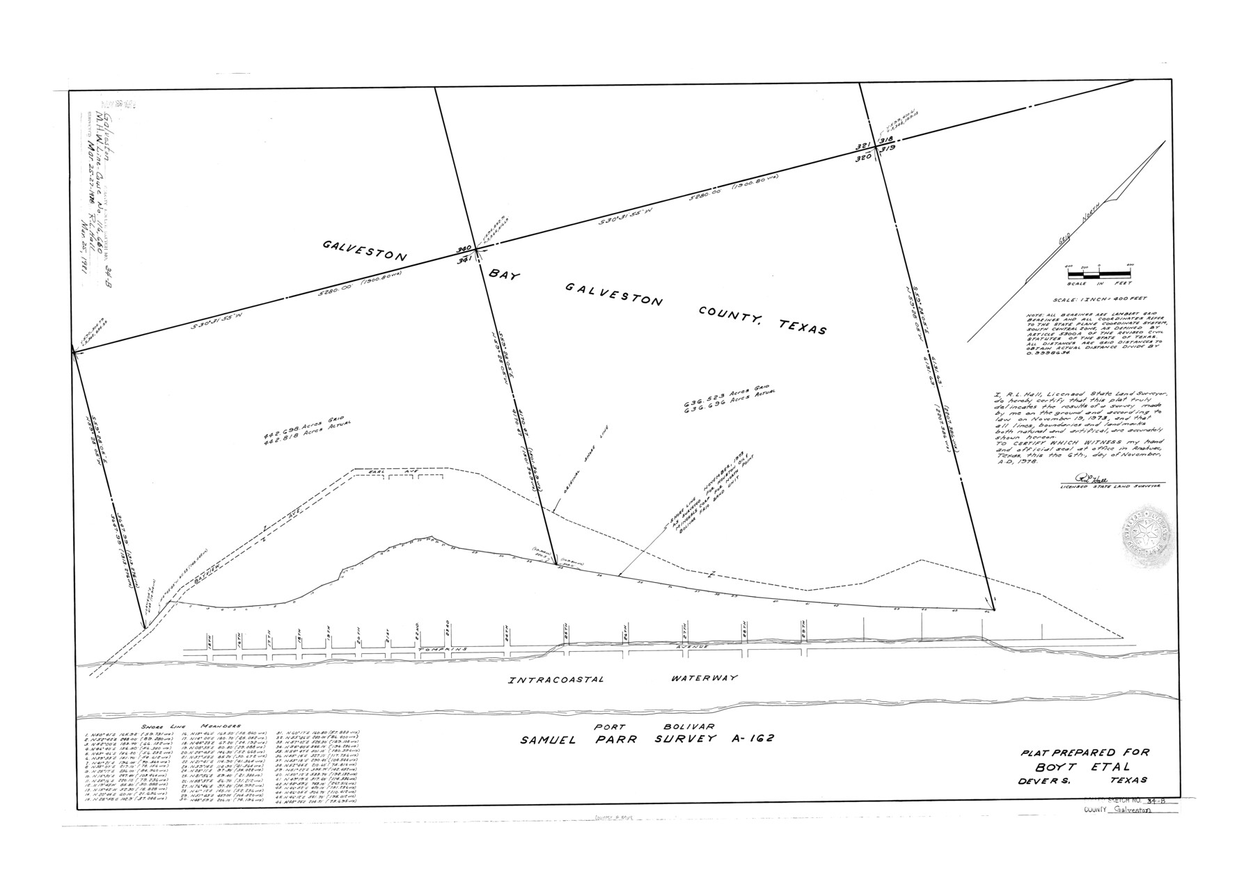
Galveston County Rolled Sketch 34B
[M.H.W. line - Cause 116,660]
-
Map/Doc
5968
-
Collection
General Map Collection
-
Object Dates
1981/3/25 (File Date)
1978/11/6 (Creation Date)
-
People and Organizations
R.L. Hall (Surveyor/Engineer)
-
Counties
Galveston
-
Subjects
Surveying Rolled Sketch
-
Height x Width
28.4 x 40.0 inches
72.1 x 101.6 cm
-
Medium
mylar, print
-
Scale
1" = 400 feet
Part of: General Map Collection
Houston & Great Northern RR through Smith & other counties

Print $66.00
- Digital $50.00
Houston & Great Northern RR through Smith & other counties
1872
Size 14.2 x 8.4 inches
Map/Doc 64339
Presidio County Working Sketch 63

Print $40.00
- Digital $50.00
Presidio County Working Sketch 63
1958
Size 64.8 x 38.9 inches
Map/Doc 71740
Kendall County Working Sketch 4

Print $20.00
- Digital $50.00
Kendall County Working Sketch 4
1946
Size 25.7 x 24.3 inches
Map/Doc 66676
Hudspeth County Sketch File 49

Print $18.00
- Digital $50.00
Hudspeth County Sketch File 49
1986
Size 11.2 x 8.7 inches
Map/Doc 27065
Duval County Boundary File 3h

Print $4.00
- Digital $50.00
Duval County Boundary File 3h
Size 10.0 x 8.0 inches
Map/Doc 52749
Montague County Working Sketch 12

Print $20.00
- Digital $50.00
Montague County Working Sketch 12
1937
Size 23.3 x 23.8 inches
Map/Doc 71078
Zavala County Boundary File 3

Print $44.00
- Digital $50.00
Zavala County Boundary File 3
Size 9.4 x 7.3 inches
Map/Doc 60258
Old Miscellaneous File 9

Print $4.00
- Digital $50.00
Old Miscellaneous File 9
1871
Size 9.8 x 8.0 inches
Map/Doc 75433
Gaines County Working Sketch 15

Print $40.00
- Digital $50.00
Gaines County Working Sketch 15
1958
Size 66.3 x 34.0 inches
Map/Doc 69315
Hood County Sketch File 21

Print $12.00
- Digital $50.00
Hood County Sketch File 21
1873
Size 7.8 x 6.7 inches
Map/Doc 26609
Floyd County Sketch File 18

Print $32.00
- Digital $50.00
Floyd County Sketch File 18
1913
Size 13.4 x 9.0 inches
Map/Doc 22753
Eastland County Working Sketch 46

Print $20.00
- Digital $50.00
Eastland County Working Sketch 46
1980
Size 33.4 x 36.6 inches
Map/Doc 68827
You may also like
Crane County Rolled Sketch 23

Print $20.00
- Digital $50.00
Crane County Rolled Sketch 23
2002
Size 23.9 x 34.3 inches
Map/Doc 76426
McLennan County Boundary File 1a

Print $14.00
- Digital $50.00
McLennan County Boundary File 1a
Size 8.0 x 6.6 inches
Map/Doc 56941
Erath County Working Sketch 44

Print $20.00
- Digital $50.00
Erath County Working Sketch 44
1981
Size 29.7 x 30.4 inches
Map/Doc 69125
Texas-Oklahoma Boundary Line: brief summary of the lands surveyed and the lands not surveyed in the dispute between Oklahoma vs. Texas

Print $356.00
- Digital $50.00
Texas-Oklahoma Boundary Line: brief summary of the lands surveyed and the lands not surveyed in the dispute between Oklahoma vs. Texas
1923
Size 6.0 x 9.2 inches
Map/Doc 3061
Carson County Working Sketch 1

Print $40.00
- Digital $50.00
Carson County Working Sketch 1
Size 44.6 x 77.4 inches
Map/Doc 67872
Brooks County Working Sketch 18

Print $20.00
- Digital $50.00
Brooks County Working Sketch 18
1981
Size 20.6 x 32.4 inches
Map/Doc 67802
Map of Coleman County

Print $20.00
- Digital $50.00
Map of Coleman County
1878
Size 23.9 x 20.3 inches
Map/Doc 3412
Kinney County Working Sketch 18

Print $40.00
- Digital $50.00
Kinney County Working Sketch 18
1948
Size 56.7 x 40.5 inches
Map/Doc 70200
Jasper County Rolled Sketch 8

Print $20.00
- Digital $50.00
Jasper County Rolled Sketch 8
Size 17.8 x 12.0 inches
Map/Doc 6358
Bowie County Sketch File 7d

Print $40.00
- Digital $50.00
Bowie County Sketch File 7d
1927
Size 16.2 x 13.7 inches
Map/Doc 10944
El Paso County Rolled Sketch VD

Print $40.00
- Digital $50.00
El Paso County Rolled Sketch VD
1915
Size 18.4 x 67.4 inches
Map/Doc 8862
Jack County Sketch File 36

Print $120.00
- Digital $50.00
Jack County Sketch File 36
1882
Size 16.3 x 11.0 inches
Map/Doc 27575