Gray County Boundary File 1
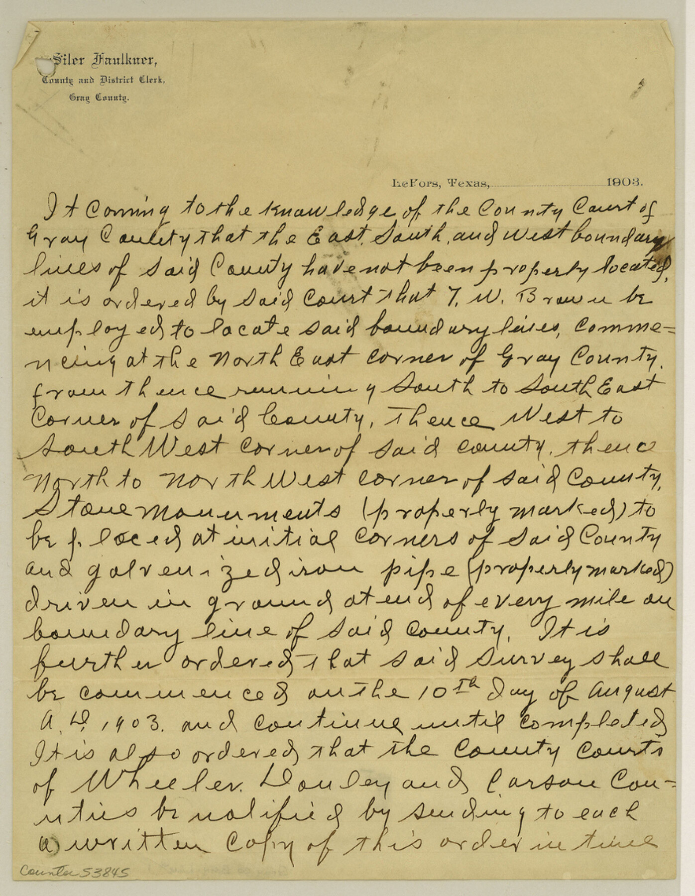
[Court Order regarding the Boundary lines of Gray County]
-
Map/Doc
53845
-
Collection
General Map Collection
-
Counties
Gray
-
Subjects
County Boundaries
-
Height x Width
11.4 x 8.8 inches
29.0 x 22.4 cm
Part of: General Map Collection
Map of Starr County State of Texas

Print $20.00
- Digital $50.00
Map of Starr County State of Texas
1911
Size 25.1 x 23.2 inches
Map/Doc 4048
Eastland County Sketch File 20

Print $62.00
- Digital $50.00
Eastland County Sketch File 20
1987
Size 9.1 x 11.3 inches
Map/Doc 21609
Brewster County Working Sketch 59

Print $20.00
- Digital $50.00
Brewster County Working Sketch 59
1955
Size 24.6 x 19.0 inches
Map/Doc 67660
Travis County Rolled Sketch 31

Print $20.00
- Digital $50.00
Travis County Rolled Sketch 31
1943
Size 43.4 x 27.3 inches
Map/Doc 8033
Zavala County

Print $20.00
- Digital $50.00
Zavala County
1915
Size 38.6 x 46.6 inches
Map/Doc 16940
Map of Erath County

Print $40.00
- Digital $50.00
Map of Erath County
1896
Size 48.6 x 45.1 inches
Map/Doc 66821
Brazoria County NRC Article 33.136 Sketch 3

Print $20.00
- Digital $50.00
Brazoria County NRC Article 33.136 Sketch 3
2002
Size 40.6 x 29.6 inches
Map/Doc 77039
Zavala County Sketch File 22

Print $4.00
- Digital $50.00
Zavala County Sketch File 22
1885
Size 11.0 x 8.4 inches
Map/Doc 41378
Presidio County Sketch File 34

Print $4.00
- Digital $50.00
Presidio County Sketch File 34
1891
Size 14.3 x 8.7 inches
Map/Doc 34484
Zapata County Working Sketch 18

Print $20.00
- Digital $50.00
Zapata County Working Sketch 18
1975
Size 43.2 x 29.1 inches
Map/Doc 62069
Comanche County Working Sketch 3

Print $20.00
- Digital $50.00
Comanche County Working Sketch 3
1919
Size 21.9 x 12.6 inches
Map/Doc 68137
Andrews County

Print $40.00
- Digital $50.00
Andrews County
1901
Size 35.9 x 49.7 inches
Map/Doc 4872
You may also like
Map of the River Sabine from its mouth on the Gulf of Mexico in the sea to Logan's Ferry

Print $20.00
- Digital $50.00
Map of the River Sabine from its mouth on the Gulf of Mexico in the sea to Logan's Ferry
1842
Size 37.5 x 9.4 inches
Map/Doc 93767
Plat showing proposed counties to be taken from Zapata, Starr & Hidalgo Counties

Print $20.00
- Digital $50.00
Plat showing proposed counties to be taken from Zapata, Starr & Hidalgo Counties
1911
Size 24.8 x 27.8 inches
Map/Doc 2660
Cherokee County

Print $40.00
- Digital $50.00
Cherokee County
1933
Size 57.0 x 38.8 inches
Map/Doc 77236
Public Land on Mustang Island, Nueces County

Print $20.00
- Digital $50.00
Public Land on Mustang Island, Nueces County
1945
Size 43.4 x 40.1 inches
Map/Doc 73335
Panola County Working Sketch 18

Print $20.00
- Digital $50.00
Panola County Working Sketch 18
1945
Map/Doc 71427
Coke County Working Sketch 14

Print $40.00
- Digital $50.00
Coke County Working Sketch 14
1948
Size 50.3 x 43.1 inches
Map/Doc 68051
Montgomery County Working Sketch Graphic Index, Sheet 2 (Sketches 36 to Most Recent)

Print $40.00
- Digital $50.00
Montgomery County Working Sketch Graphic Index, Sheet 2 (Sketches 36 to Most Recent)
1943
Size 42.9 x 51.9 inches
Map/Doc 76647
Hudspeth County Rolled Sketch 69

Print $20.00
- Digital $50.00
Hudspeth County Rolled Sketch 69
1973
Size 13.3 x 20.5 inches
Map/Doc 7716
Brazoria County Rolled Sketch AH

Print $20.00
- Digital $50.00
Brazoria County Rolled Sketch AH
Size 43.9 x 31.2 inches
Map/Doc 10714
Maps & Lists Showing Prison Lands (Oil & Gas) Leased as of June 1955

Digital $50.00
Maps & Lists Showing Prison Lands (Oil & Gas) Leased as of June 1955
1930
Size 24.4 x 26.8 inches
Map/Doc 62876
Cherokee County Working Sketch 9

Print $20.00
- Digital $50.00
Cherokee County Working Sketch 9
1957
Size 46.9 x 34.0 inches
Map/Doc 67964
