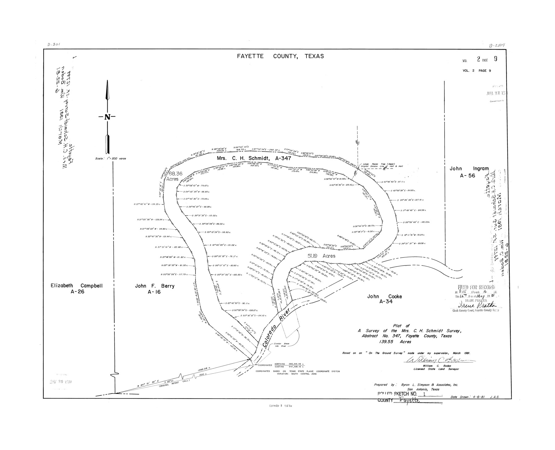
Fayette County Rolled Sketch 1
Plat of a survey of the Mrs. C.H. Schmidt survey, abstract no. 347, Fayette County, Texas, 139.55 acres
-
Map/Doc
5876
-
Collection
General Map Collection
-
Object Dates
1981 (Survey Date)
1981/6/22 (File Date)
1981/4/6 (Creation Date)
-
People and Organizations
William C. Boden (Surveyor/Engineer)
-
Counties
Fayette
-
Subjects
Surveying Rolled Sketch
-
Height x Width
20.9 x 25.8 inches
53.1 x 65.5 cm
-
Scale
1" = 200 varas
Part of: General Map Collection
Atascosa County Rolled Sketch 22

Print $40.00
- Digital $50.00
Atascosa County Rolled Sketch 22
1917
Size 26.5 x 57.2 inches
Map/Doc 8922
Montague County Rolled Sketch 3

Print $20.00
- Digital $50.00
Montague County Rolled Sketch 3
1940
Size 24.0 x 15.9 inches
Map/Doc 6787
Galveston County

Print $20.00
- Digital $50.00
Galveston County
1860
Size 20.2 x 31.4 inches
Map/Doc 3575
Map of Hunt County

Print $20.00
- Digital $50.00
Map of Hunt County
1851
Size 27.0 x 19.8 inches
Map/Doc 4569
Stephens County Sketch File 6

Print $4.00
- Digital $50.00
Stephens County Sketch File 6
Size 9.1 x 9.1 inches
Map/Doc 37021
Right of Way and Track Map International & Gt. Northern Ry. operated by the International & Gt. Northern Ry. Co., Gulf Division, Columbia Branch

Print $40.00
- Digital $50.00
Right of Way and Track Map International & Gt. Northern Ry. operated by the International & Gt. Northern Ry. Co., Gulf Division, Columbia Branch
1917
Size 25.3 x 56.7 inches
Map/Doc 64601
Flight Mission No. CUG-1P, Frame 69, Kleberg County

Print $20.00
- Digital $50.00
Flight Mission No. CUG-1P, Frame 69, Kleberg County
1956
Size 18.6 x 22.3 inches
Map/Doc 86134
Flight Mission No. CLL-1N, Frame 18, Willacy County

Print $20.00
- Digital $50.00
Flight Mission No. CLL-1N, Frame 18, Willacy County
1954
Size 18.3 x 22.1 inches
Map/Doc 87005
Louisiana and Texas Intracoastal Waterway

Print $20.00
- Digital $50.00
Louisiana and Texas Intracoastal Waterway
1929
Size 13.6 x 19.8 inches
Map/Doc 83345
Flight Mission No. BRA-7M, Frame 120, Jefferson County

Print $20.00
- Digital $50.00
Flight Mission No. BRA-7M, Frame 120, Jefferson County
1953
Size 18.7 x 22.4 inches
Map/Doc 85514
Yoakum County Sketch File 4

Print $30.00
- Digital $50.00
Yoakum County Sketch File 4
Size 8.0 x 7.8 inches
Map/Doc 40718
Flight Mission No. CGI-3N, Frame 97, Cameron County

Print $20.00
- Digital $50.00
Flight Mission No. CGI-3N, Frame 97, Cameron County
1954
Size 18.6 x 22.1 inches
Map/Doc 84577
You may also like
Starr County Sketch File D

Print $8.00
- Digital $50.00
Starr County Sketch File D
1892
Size 14.2 x 8.7 inches
Map/Doc 36915
Burnet County Boundary File 3

Print $18.00
- Digital $50.00
Burnet County Boundary File 3
Size 12.8 x 8.2 inches
Map/Doc 50863
Map of Hamilton County

Print $20.00
- Digital $50.00
Map of Hamilton County
1872
Size 14.9 x 21.9 inches
Map/Doc 4556
King County Sketch File 3

Print $20.00
- Digital $50.00
King County Sketch File 3
Size 22.2 x 27.1 inches
Map/Doc 11934
[Township 3 North, Block 31]
![91217, [Township 3 North, Block 31], Twichell Survey Records](https://historictexasmaps.com/wmedia_w700/maps/91217-1.tif.jpg)
Print $3.00
- Digital $50.00
[Township 3 North, Block 31]
Size 11.6 x 13.4 inches
Map/Doc 91217
Map of State University Land, Pecos County, Texas

Print $20.00
- Digital $50.00
Map of State University Land, Pecos County, Texas
1929
Size 28.4 x 22.7 inches
Map/Doc 91631
Lavaca County Working Sketch 17

Print $20.00
- Digital $50.00
Lavaca County Working Sketch 17
1979
Size 34.7 x 44.6 inches
Map/Doc 70370
Schleicher County Sketch File 39

Print $9.00
- Digital $50.00
Schleicher County Sketch File 39
1958
Size 14.8 x 9.4 inches
Map/Doc 36538
Trinity County Sketch File 24

Print $4.00
- Digital $50.00
Trinity County Sketch File 24
Size 7.5 x 10.5 inches
Map/Doc 38556
Andrews County Working Sketch 34

Print $20.00
- Digital $50.00
Andrews County Working Sketch 34
1990
Size 29.9 x 31.0 inches
Map/Doc 67080
Flight Mission No. BRE-2P, Frame 132, Nueces County

Print $20.00
- Digital $50.00
Flight Mission No. BRE-2P, Frame 132, Nueces County
1956
Size 18.4 x 22.5 inches
Map/Doc 86805
Mason County Working Sketch 16

Print $20.00
- Digital $50.00
Mason County Working Sketch 16
1980
Size 28.2 x 36.5 inches
Map/Doc 70852