Rockwall County Boundary File 9
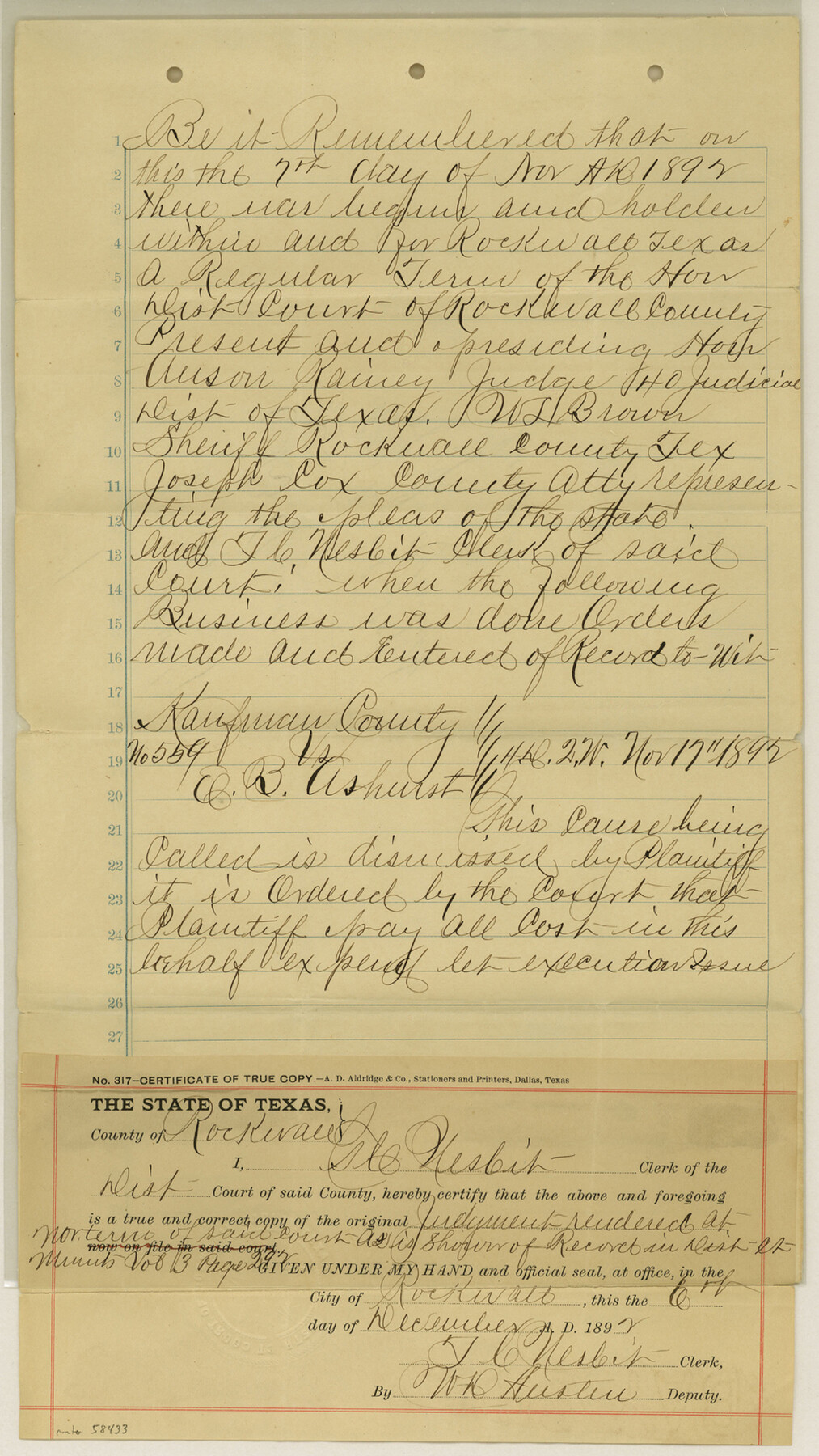
Kaufman County vs. E. B. Ashurst Certified Copy of Judgment; Rockwall County Final Judgment of Court on Co. bdy between Kaufman and Rockwall Cos.
-
Map/Doc
58433
-
Collection
General Map Collection
-
Counties
Rockwall
-
Subjects
County Boundaries
-
Height x Width
15.9 x 9.0 inches
40.4 x 22.9 cm
Part of: General Map Collection
Webb County Working Sketch 52

Print $20.00
- Digital $50.00
Webb County Working Sketch 52
1951
Size 30.8 x 37.3 inches
Map/Doc 72418
Flight Mission No. DAH-17M, Frame 18, Orange County

Print $20.00
- Digital $50.00
Flight Mission No. DAH-17M, Frame 18, Orange County
1953
Size 18.5 x 22.6 inches
Map/Doc 86881
Zavala County Sketch File 33

Print $7.00
- Digital $50.00
Zavala County Sketch File 33
1886
Size 10.9 x 8.3 inches
Map/Doc 41392
Wichita County Working Sketch 15

Print $20.00
- Digital $50.00
Wichita County Working Sketch 15
1919
Size 29.9 x 38.5 inches
Map/Doc 72525
Mason County Sketch File 9

Print $20.00
- Digital $50.00
Mason County Sketch File 9
1880
Size 20.5 x 13.9 inches
Map/Doc 12034
University Land Field Notes for Blocks 29 through 33, Crockett County

University Land Field Notes for Blocks 29 through 33, Crockett County
Map/Doc 81715
Parmer County Sketch File 2

Print $26.00
- Digital $50.00
Parmer County Sketch File 2
1903
Size 7.2 x 8.7 inches
Map/Doc 33626
Maps of Gulf Intracoastal Waterway, Texas - Sabine River to the Rio Grande and connecting waterways including ship channels

Print $20.00
- Digital $50.00
Maps of Gulf Intracoastal Waterway, Texas - Sabine River to the Rio Grande and connecting waterways including ship channels
1966
Size 14.6 x 22.3 inches
Map/Doc 61957
Kleberg County Rolled Sketch 10-8

Print $20.00
- Digital $50.00
Kleberg County Rolled Sketch 10-8
1951
Size 36.6 x 33.7 inches
Map/Doc 9370
Menard County Sketch File 26

Print $8.00
- Digital $50.00
Menard County Sketch File 26
1936
Size 8.7 x 14.3 inches
Map/Doc 31560
[10th St and 29th St Groins - Galveston]
![73621, [10th St and 29th St Groins - Galveston], General Map Collection](https://historictexasmaps.com/wmedia_w700/maps/73621-1.tif.jpg)
Print $6.00
- Digital $50.00
[10th St and 29th St Groins - Galveston]
1983
Size 25.6 x 35.2 inches
Map/Doc 73621
Orange County NRC Article 33.136 Sketch 1

Print $20.00
- Digital $50.00
Orange County NRC Article 33.136 Sketch 1
2004
Size 23.8 x 34.5 inches
Map/Doc 81979
You may also like
Mason County Working Sketch 7

Print $20.00
- Digital $50.00
Mason County Working Sketch 7
1945
Size 35.8 x 43.9 inches
Map/Doc 70843
Hartley County

Print $40.00
- Digital $50.00
Hartley County
1925
Size 41.1 x 48.5 inches
Map/Doc 73174
Flight Mission No. DAG-18K, Frame 180, Matagorda County

Print $20.00
- Digital $50.00
Flight Mission No. DAG-18K, Frame 180, Matagorda County
1952
Size 18.6 x 22.3 inches
Map/Doc 86372
Val Verde County Working Sketch 105

Print $20.00
- Digital $50.00
Val Verde County Working Sketch 105
1983
Size 39.8 x 43.0 inches
Map/Doc 72240
Kerr County Rolled Sketch 12

Print $20.00
- Digital $50.00
Kerr County Rolled Sketch 12
1951
Size 22.6 x 28.5 inches
Map/Doc 6497
Kleberg County Boundary File 4a

Print $40.00
- Digital $50.00
Kleberg County Boundary File 4a
Size 23.3 x 62.2 inches
Map/Doc 64997
Brewster County Sketch File NS-4g

Print $4.00
- Digital $50.00
Brewster County Sketch File NS-4g
1930
Size 10.5 x 7.2 inches
Map/Doc 15981
Flight Mission No. DCL-6C, Frame 19, Kenedy County

Print $20.00
- Digital $50.00
Flight Mission No. DCL-6C, Frame 19, Kenedy County
1943
Size 18.6 x 22.4 inches
Map/Doc 85876
Newton County Sketch File 48

Print $4.00
- Digital $50.00
Newton County Sketch File 48
Size 12.4 x 7.9 inches
Map/Doc 32460
Jefferson Co.

Print $20.00
- Digital $50.00
Jefferson Co.
1918
Size 46.7 x 40.8 inches
Map/Doc 16860
Brazoria County Aerial Photograph Index Sheet 7

Print $20.00
- Digital $50.00
Brazoria County Aerial Photograph Index Sheet 7
1953
Size 23.9 x 19.8 inches
Map/Doc 83669
A true copy of Peck's field book No. 7 pages 50 to 55, except classfication of lands

Print $40.00
- Digital $50.00
A true copy of Peck's field book No. 7 pages 50 to 55, except classfication of lands
Size 6.1 x 54.3 inches
Map/Doc 89666