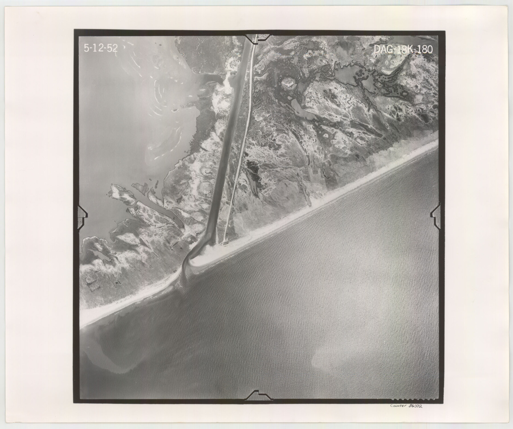
Flight Mission No. DAG-18K, Frame 180, Matagorda County
DAG-18K-180
-
Map/Doc
86372
-
Collection
General Map Collection
-
Object Dates
1952/5/12 (Creation Date)
-
People and Organizations
U. S. Department of Agriculture (Publisher)
-
Counties
Matagorda
-
Subjects
Aerial Photograph
-
Height x Width
18.6 x 22.3 inches
47.2 x 56.6 cm
-
Comments
Flown by Aero Exploration Company of Tulsa, Oklahoma.
Part of: General Map Collection
Foard County Sketch File 33

Print $26.00
- Digital $50.00
Foard County Sketch File 33
1958
Size 11.4 x 8.9 inches
Map/Doc 22866
Plan of the City of Austin

Print $40.00
- Digital $50.00
Plan of the City of Austin
1840
Size 56.2 x 42.0 inches
Map/Doc 4837
Flight Mission No. DIX-10P, Frame 167, Aransas County

Print $20.00
- Digital $50.00
Flight Mission No. DIX-10P, Frame 167, Aransas County
1956
Size 18.6 x 22.3 inches
Map/Doc 83957
Polk County Sketch File 23

Print $20.00
- Digital $50.00
Polk County Sketch File 23
Size 18.0 x 18.6 inches
Map/Doc 12191
Hill County Sketch File 18

Print $26.00
- Digital $50.00
Hill County Sketch File 18
1852
Size 8.6 x 4.9 inches
Map/Doc 26486
Henderson County Rolled Sketch 11

Print $20.00
- Digital $50.00
Henderson County Rolled Sketch 11
1915
Size 29.1 x 42.4 inches
Map/Doc 75948
Hunt County Sketch File A

Print $4.00
- Digital $50.00
Hunt County Sketch File A
1884
Size 14.4 x 8.3 inches
Map/Doc 27170
Anderson County Rolled Sketch 12

Print $20.00
- Digital $50.00
Anderson County Rolled Sketch 12
1954
Size 24.6 x 21.3 inches
Map/Doc 77157
Orange County Working Sketch 18

Print $20.00
- Digital $50.00
Orange County Working Sketch 18
1931
Size 28.1 x 36.9 inches
Map/Doc 71350
Wharton County Sketch File 13a

Print $20.00
- Digital $50.00
Wharton County Sketch File 13a
1894
Size 18.3 x 28.7 inches
Map/Doc 12663
Bosque County Working Sketch 21

Print $40.00
- Digital $50.00
Bosque County Working Sketch 21
1984
Size 38.5 x 55.1 inches
Map/Doc 67454
Cameron County Working Sketch 2

Print $40.00
- Digital $50.00
Cameron County Working Sketch 2
1937
Size 43.1 x 51.7 inches
Map/Doc 67881
You may also like
Flight Mission No. DQO-3K, Frame 25, Galveston County

Print $20.00
- Digital $50.00
Flight Mission No. DQO-3K, Frame 25, Galveston County
1952
Size 18.8 x 22.4 inches
Map/Doc 85066
Cameron County Rolled Sketch 10

Print $20.00
- Digital $50.00
Cameron County Rolled Sketch 10
Size 38.5 x 44.5 inches
Map/Doc 8566
Sabine County Working Sketch 6

Print $20.00
- Digital $50.00
Sabine County Working Sketch 6
1918
Size 17.5 x 17.6 inches
Map/Doc 63677
Railroad Track Map, H&TCRRCo., Falls County, Texas

Print $4.00
- Digital $50.00
Railroad Track Map, H&TCRRCo., Falls County, Texas
1918
Size 11.7 x 18.7 inches
Map/Doc 62841
Blocks 56 and 57, Townships 1 and 2, resurvey of Texas & Pacific Railway Lands in the eighty mile reservation

Print $20.00
- Digital $50.00
Blocks 56 and 57, Townships 1 and 2, resurvey of Texas & Pacific Railway Lands in the eighty mile reservation
1931
Size 41.4 x 31.4 inches
Map/Doc 2246
[E. L. & R. R. Block 10]
![91352, [E. L. & R. R. Block 10], Twichell Survey Records](https://historictexasmaps.com/wmedia_w700/maps/91352-1.tif.jpg)
Print $20.00
- Digital $50.00
[E. L. & R. R. Block 10]
Size 25.6 x 15.8 inches
Map/Doc 91352
PSL Field Notes for Blocks A19, A20, A22, A23, A26, A28, A29, A30, A31, A32, A33, A34, A35, A36, A37, A38, A39, A40, A41 in Andrews County

PSL Field Notes for Blocks A19, A20, A22, A23, A26, A28, A29, A30, A31, A32, A33, A34, A35, A36, A37, A38, A39, A40, A41 in Andrews County
Map/Doc 81642
Padre Island National Seashore, Texas - Dependent Resurvey

Print $4.00
- Digital $50.00
Padre Island National Seashore, Texas - Dependent Resurvey
2001
Size 18.2 x 24.3 inches
Map/Doc 60548
Galveston County NRC Article 33.136 Sketch 97

Print $414.00
Galveston County NRC Article 33.136 Sketch 97
2024
Map/Doc 97407
Flight Mission No. BRA-3M, Frame 190, Jefferson County

Print $20.00
- Digital $50.00
Flight Mission No. BRA-3M, Frame 190, Jefferson County
1953
Size 18.6 x 22.3 inches
Map/Doc 85405
Bexar County Sketch File 36

Print $14.00
- Digital $50.00
Bexar County Sketch File 36
1868
Size 8.8 x 7.6 inches
Map/Doc 14500
Fayette County Boundary File 6

Print $20.00
- Digital $50.00
Fayette County Boundary File 6
Size 14.4 x 9.0 inches
Map/Doc 53391