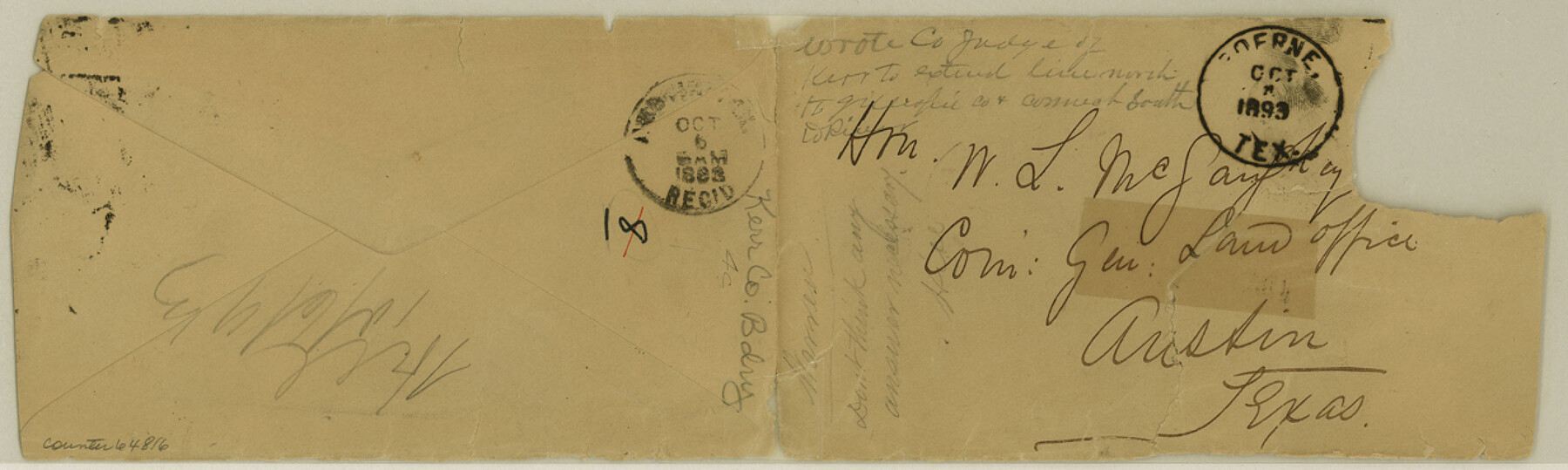
Kerr County Boundary File 4c
[Letter] to Co. Judge of Kerr to extend line north to Gillespie Co. & connect South to River
-
Map/Doc
64816
-
Collection
General Map Collection
-
Counties
Kerr
-
Subjects
County Boundaries
-
Height x Width
3.7 x 12.3 inches
9.4 x 31.2 cm
Part of: General Map Collection
Flight Mission No. BRA-3M, Frame 193, Jefferson County

Print $20.00
- Digital $50.00
Flight Mission No. BRA-3M, Frame 193, Jefferson County
1953
Size 18.6 x 22.3 inches
Map/Doc 85408
Montague County

Print $20.00
- Digital $50.00
Montague County
1875
Size 24.6 x 21.1 inches
Map/Doc 3884
Flight Mission No. BRA-16M, Frame 56, Jefferson County

Print $20.00
- Digital $50.00
Flight Mission No. BRA-16M, Frame 56, Jefferson County
1953
Size 18.6 x 22.5 inches
Map/Doc 85673
Knox County Working Sketch 6

Print $20.00
- Digital $50.00
Knox County Working Sketch 6
1937
Size 31.4 x 18.2 inches
Map/Doc 70248
Carson County Sketch File 4

Print $4.00
- Digital $50.00
Carson County Sketch File 4
1901
Size 9.7 x 6.2 inches
Map/Doc 17351
Rains County Boundary File 71

Print $6.00
- Digital $50.00
Rains County Boundary File 71
Size 8.7 x 3.5 inches
Map/Doc 58094
Bandera County Working Sketch 3

Print $20.00
- Digital $50.00
Bandera County Working Sketch 3
1914
Size 14.5 x 13.9 inches
Map/Doc 67596
Map of Erath County

Print $20.00
- Digital $50.00
Map of Erath County
1856
Size 22.4 x 28.0 inches
Map/Doc 3519
Roberts County Working Sketch 16

Print $20.00
- Digital $50.00
Roberts County Working Sketch 16
1975
Size 37.1 x 39.8 inches
Map/Doc 63542
Map of the State of Texas from the Latest Authorities

Print $20.00
- Digital $50.00
Map of the State of Texas from the Latest Authorities
1853
Size 14.2 x 17.4 inches
Map/Doc 89221
Rains County Sketch File 4

Print $4.00
- Digital $50.00
Rains County Sketch File 4
1853
Size 11.2 x 8.7 inches
Map/Doc 34951
La Salle County Working Sketch 43

Print $20.00
- Digital $50.00
La Salle County Working Sketch 43
1976
Size 32.7 x 40.1 inches
Map/Doc 70344
You may also like
Harris County Working Sketch 44

Print $20.00
- Digital $50.00
Harris County Working Sketch 44
1941
Size 24.9 x 38.3 inches
Map/Doc 65936
Trinity County Rolled Sketch 3

Print $40.00
- Digital $50.00
Trinity County Rolled Sketch 3
1948
Size 33.8 x 50.3 inches
Map/Doc 10025
Map of Fannin County

Print $20.00
- Digital $50.00
Map of Fannin County
1845
Size 34.7 x 47.0 inches
Map/Doc 87153
Jno. W. Pritchett Preliminary Official LO Map for Lubbock [County]
![89901, Jno. W. Pritchett Preliminary Official LO Map for Lubbock [County], Twichell Survey Records](https://historictexasmaps.com/wmedia_w700/maps/89901-1.tif.jpg)
Print $20.00
- Digital $50.00
Jno. W. Pritchett Preliminary Official LO Map for Lubbock [County]
Size 41.1 x 40.3 inches
Map/Doc 89901
Hale County Rolled Sketch 10

Print $40.00
- Digital $50.00
Hale County Rolled Sketch 10
Size 52.4 x 28.3 inches
Map/Doc 76447
Real County Working Sketch 35

Print $20.00
- Digital $50.00
Real County Working Sketch 35
1949
Size 27.7 x 23.6 inches
Map/Doc 71927
Hays County Sketch File 25a

Print $2.00
- Digital $50.00
Hays County Sketch File 25a
1881
Size 10.2 x 8.0 inches
Map/Doc 26251
Kendall County Rolled Sketch 8

Print $20.00
- Digital $50.00
Kendall County Rolled Sketch 8
1994
Size 17.0 x 18.3 inches
Map/Doc 6461
[Public School Land Blocks]
![93152, [Public School Land Blocks], Twichell Survey Records](https://historictexasmaps.com/wmedia_w700/maps/93152-1.tif.jpg)
Print $40.00
- Digital $50.00
[Public School Land Blocks]
Size 41.3 x 113.1 inches
Map/Doc 93152

General Highway Map, Nueces County, Texas

Print $20.00
General Highway Map, Nueces County, Texas
1940
Size 24.6 x 18.4 inches
Map/Doc 79210
Crane County Working Sketch 6

Print $40.00
- Digital $50.00
Crane County Working Sketch 6
1928
Size 92.2 x 25.3 inches
Map/Doc 68283