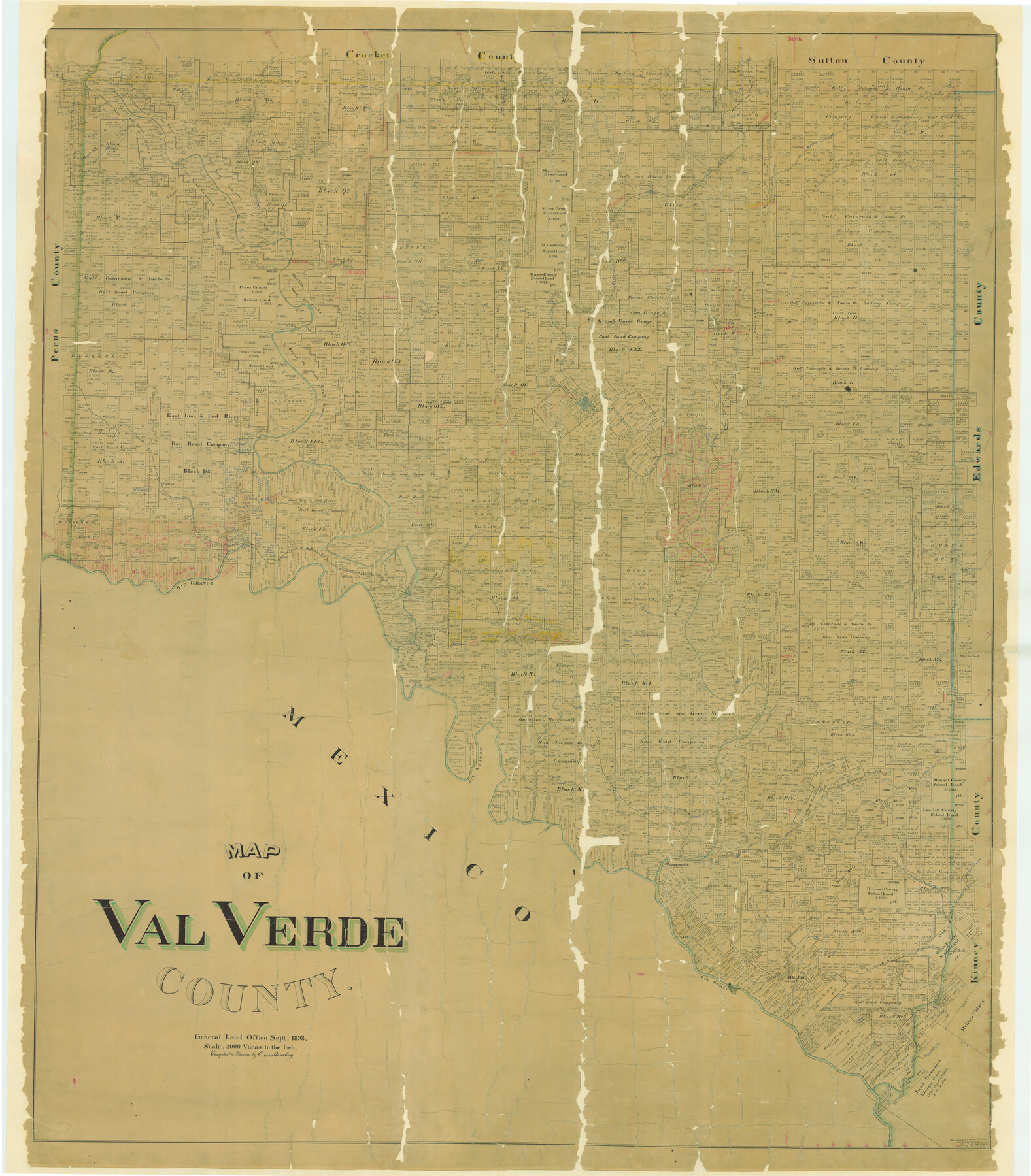
Map of Val Verde County
-
Map/Doc
82014
-
Collection
General Map Collection
-
Object Dates
1898 (Creation Date)
-
People and Organizations
Texas General Land Office (Publisher)
E. von Rosenberg (Draftsman)
E. von Rosenberg (Compiler)
-
Counties
Val Verde
-
Subjects
County
-
Height x Width
80.4 x 70.4 inches
204.2 x 178.8 cm
-
Comments
See counter 82013 for west part. See counter 82014 for digitally combined image.
Conservation funded in 2004 with donation from Glen Sample Ely. -
Features
Howards Creek
Johnsons Run
McKees
Johnsons Ranch
North Prong of Buckley's Creek
Fielder's Creek
Col. Shaftern's Trail
Indian Trail
Buckley's Creek
Bandera Road
China Creek
Dry Creek
Lowe's Creek
Devil's River
Beaver Lake
Old Camp Shafter
Old Mouth of Howard's Creek
Oppenheimer Springs
Chalk Bluff
Yellow Bluff
Ricardo Creek
Dry Devil's River
Dolan Springs
Pecan Springs
Blue Hills
Comstock and Ozona Road
Ozona Road
Comstock Road
Norris Ranch
Lewis Cañon
Fielders Ranch
Camp Hudson
East Fork of Dolan's Creek
Dolan's Creek
Jack Springs
Jack Branch of Ricardo Creek
Grape Springs
Sycamore Springs
R&M Ranch
Osman
Ames Ranch
Cañon Grande
Willow Springs
Langtry
GH&SA
Dead Man's Cañon
Rio Grande
Red Bluff Cañon
Southern Pacific Railroad Company
GH&SA Bridge
Deadmans Creek
Cow Creek
Seminole Springs
Painted Cave Springs
Painted Cave Station
Abandoned Railroad
Elanders Old Station
Comstock
Section House
Almonds Ranch
Evans Creek
Satan's Creek
West Prong of Cow Creek
Rocky Creek
West Fork of Sycamore Creek
East Prong of Cow Creek
Feely Station
California Creek
Lone Hill
Bullis Creek
Bluff Creek
Griner Springs
California Creek
Painted Cave Creek
West Prong of Painted Cave Creek
Goodenough Springs
Lange Cañon
San Pedro Creek
North Fork of San Pedro Creek
East Fork of San Pedro Creek
Middle Fork of Sycamore Creek
West Fork of Sycamore Creek
Dry Branch of San Pedro Creek
Devil's River Station
Sycamore Creek
Head Springs
Stampede Creek
Sienagas Creek
McKee's
Sienegas Springs
Arroyo los Poloncillos
Zacatosa Creek
Del Rio
San Felipe Creek
Poloncillo Mountain
Sugar Loaf Mountain
Conical Mountain
San Felipe
Maverick's Creek
Mud Creek
Geddis Spring
Pecos River
Part of: General Map Collection
Presidio County Rolled Sketch 120

Print $49.00
- Digital $50.00
Presidio County Rolled Sketch 120
Size 9.9 x 15.0 inches
Map/Doc 48816
Crockett County Working Sketch 90

Print $20.00
- Digital $50.00
Crockett County Working Sketch 90
1978
Size 45.2 x 43.3 inches
Map/Doc 68423
Galveston County Sketch File 26

Print $4.00
- Digital $50.00
Galveston County Sketch File 26
1860
Size 11.8 x 5.7 inches
Map/Doc 23397
United States - Gulf Coast - From Latitude 26° 33' to the Rio Grande Texas

Print $20.00
- Digital $50.00
United States - Gulf Coast - From Latitude 26° 33' to the Rio Grande Texas
1913
Size 18.4 x 27.9 inches
Map/Doc 72842
Current Miscellaneous File 11

Print $50.00
- Digital $50.00
Current Miscellaneous File 11
Size 11.2 x 8.7 inches
Map/Doc 73778
Flight Mission No. CUG-3P, Frame 81, Kleberg County

Print $20.00
- Digital $50.00
Flight Mission No. CUG-3P, Frame 81, Kleberg County
1956
Size 18.3 x 22.1 inches
Map/Doc 86256
Cameron County Sketch File 4

Print $52.00
- Digital $50.00
Cameron County Sketch File 4
1968
Size 11.3 x 8.8 inches
Map/Doc 17024
Hartley County Boundary File 3a

Print $42.00
- Digital $50.00
Hartley County Boundary File 3a
Size 8.6 x 22.0 inches
Map/Doc 54483
Jefferson County Rolled Sketch 4

Print $40.00
- Digital $50.00
Jefferson County Rolled Sketch 4
Size 36.7 x 65.3 inches
Map/Doc 9269
Burnet County Sketch File 10

Print $4.00
- Digital $50.00
Burnet County Sketch File 10
1848
Size 12.8 x 8.4 inches
Map/Doc 16690
Colorado River, Matagorda Sheet

Print $6.00
- Digital $50.00
Colorado River, Matagorda Sheet
1937
Size 30.9 x 35.8 inches
Map/Doc 65303
Map of Jack County

Print $20.00
- Digital $50.00
Map of Jack County
1882
Size 21.6 x 24.5 inches
Map/Doc 3706
You may also like
Blanco County Rolled Sketch 20

Print $36.00
- Digital $50.00
Blanco County Rolled Sketch 20
Size 30.7 x 17.0 inches
Map/Doc 87343
Flight Mission No. DQO-2K, Frame 99, Galveston County

Print $20.00
- Digital $50.00
Flight Mission No. DQO-2K, Frame 99, Galveston County
1952
Size 18.8 x 22.5 inches
Map/Doc 85026
Topographical Map of the Rio Grande, Sheet No. 21

Print $20.00
- Digital $50.00
Topographical Map of the Rio Grande, Sheet No. 21
1912
Map/Doc 89545
Copy of Surveyor's Field Book, Morris Browning - In Blocks 7, 5 & 4, I&GNRRCo., Hutchinson and Carson Counties, Texas

Print $2.00
- Digital $50.00
Copy of Surveyor's Field Book, Morris Browning - In Blocks 7, 5 & 4, I&GNRRCo., Hutchinson and Carson Counties, Texas
1888
Size 6.9 x 8.9 inches
Map/Doc 62285
Jeff Davis County Rolled Sketch 11

Print $20.00
- Digital $50.00
Jeff Davis County Rolled Sketch 11
1914
Size 17.9 x 14.4 inches
Map/Doc 6364
Fisher County

Print $20.00
- Digital $50.00
Fisher County
1921
Size 45.8 x 40.4 inches
Map/Doc 66822
Pecos County Working Sketch 1

Print $20.00
- Digital $50.00
Pecos County Working Sketch 1
Size 16.0 x 13.0 inches
Map/Doc 71471
Val Verde County Sketch File 11

Print $8.00
- Digital $50.00
Val Verde County Sketch File 11
1972
Size 11.3 x 8.9 inches
Map/Doc 39110
Refugio County Working Sketch 14

Print $20.00
- Digital $50.00
Refugio County Working Sketch 14
1961
Size 25.7 x 21.7 inches
Map/Doc 63523
Rio Grande - Fernando Sheet

Print $40.00
- Digital $50.00
Rio Grande - Fernando Sheet
1925
Size 28.8 x 66.7 inches
Map/Doc 65115
Nueces County Rolled Sketch 33

Print $47.00
- Digital $50.00
Nueces County Rolled Sketch 33
1953
Size 10.0 x 15.1 inches
Map/Doc 47612
Robertson County Rolled Sketch 1A

Print $20.00
- Digital $50.00
Robertson County Rolled Sketch 1A
1966
Size 45.3 x 28.1 inches
Map/Doc 9863