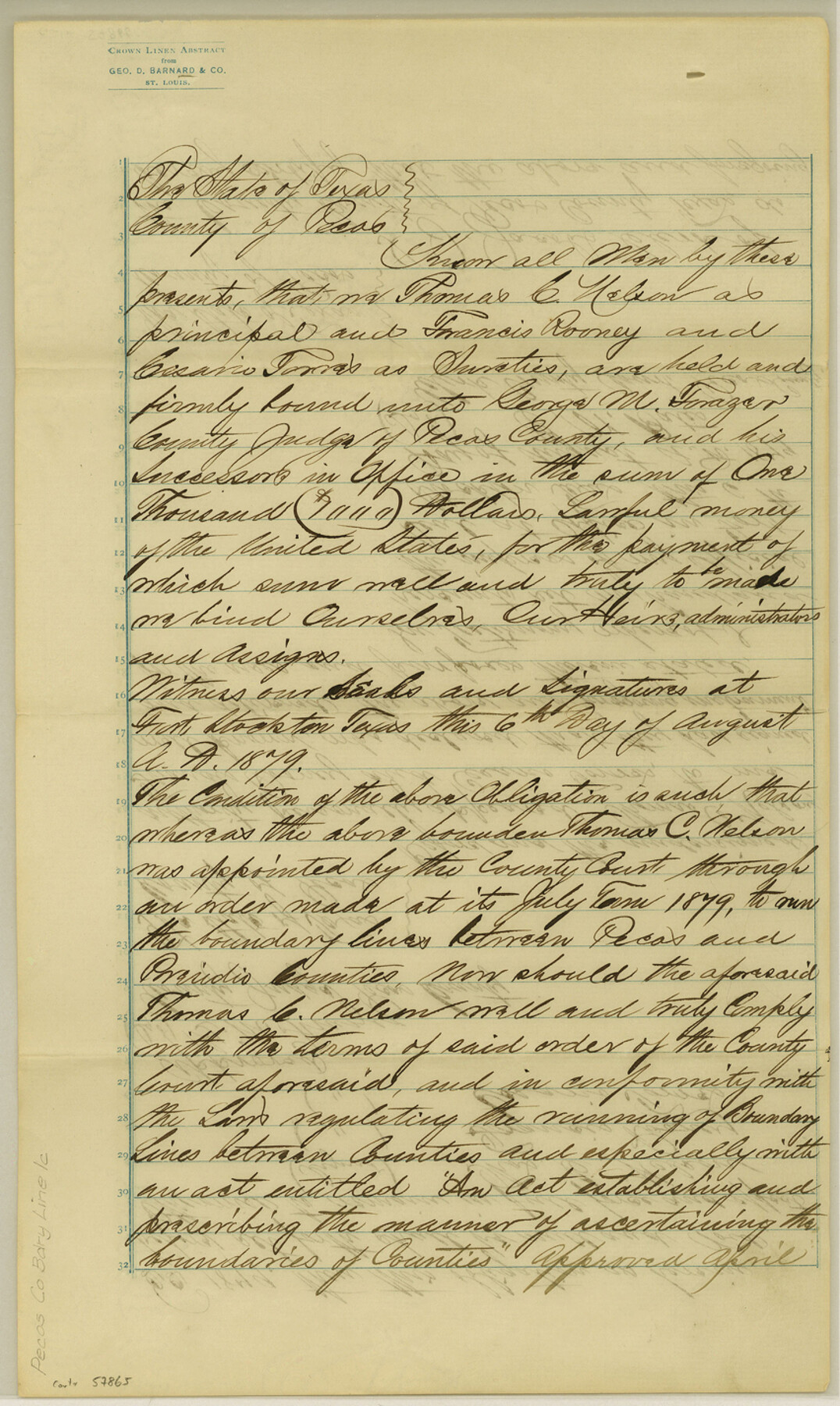
Pecos County Boundary File 1c
[Bond Certificate; Affidavit of County Surveyor]
-
Map/Doc
57865
-
Collection
General Map Collection
-
Counties
Pecos
-
Subjects
County Boundaries
-
Height x Width
14.2 x 8.5 inches
36.1 x 21.6 cm
Part of: General Map Collection
Burnet County Working Sketch 15

Print $20.00
- Digital $50.00
Burnet County Working Sketch 15
1979
Size 38.2 x 30.4 inches
Map/Doc 67858
Bell County Boundary File 3

Print $24.00
- Digital $50.00
Bell County Boundary File 3
Size 11.1 x 8.6 inches
Map/Doc 50490
Map of Concho County

Print $20.00
- Digital $50.00
Map of Concho County
1897
Size 47.0 x 39.5 inches
Map/Doc 4733
Flight Mission No. DAG-21K, Frame 119, Matagorda County

Print $20.00
- Digital $50.00
Flight Mission No. DAG-21K, Frame 119, Matagorda County
1952
Size 18.6 x 22.5 inches
Map/Doc 86445
El Paso County Rolled Sketch 42

Print $20.00
- Digital $50.00
El Paso County Rolled Sketch 42
Size 34.5 x 24.5 inches
Map/Doc 5828
Angelina County

Print $40.00
- Digital $50.00
Angelina County
1899
Size 38.9 x 49.9 inches
Map/Doc 4873

Henderson County Rolled Sketch 11

Print $20.00
- Digital $50.00
Henderson County Rolled Sketch 11
1915
Size 29.4 x 42.4 inches
Map/Doc 75950
Map of Harris County

Print $20.00
- Digital $50.00
Map of Harris County
1893
Size 26.9 x 36.5 inches
Map/Doc 66855
Fort Bend County Sketch File 9a

Print $15.00
- Digital $50.00
Fort Bend County Sketch File 9a
Size 14.6 x 8.9 inches
Map/Doc 22897
Chambers County Sketch File 35

Print $14.00
- Digital $50.00
Chambers County Sketch File 35
Size 7.1 x 7.6 inches
Map/Doc 17625
Gulf Oil Corp. Fishgide - Matagorda

Gulf Oil Corp. Fishgide - Matagorda
1960
Size 12.5 x 22.4 inches
Map/Doc 75977
You may also like

[Mrs. May Vinson Survey]
![91875, [Mrs. May Vinson Survey], Twichell Survey Records](https://historictexasmaps.com/wmedia_w700/maps/91875-1.tif.jpg)
Print $20.00
- Digital $50.00
[Mrs. May Vinson Survey]
Size 25.2 x 14.8 inches
Map/Doc 91875
Map of Asia (Inset: Palestine)

Print $20.00
- Digital $50.00
Map of Asia (Inset: Palestine)
1844
Size 12.1 x 19.0 inches
Map/Doc 93548
Sketch of Section 3, Blk. JW, Showing Quantity East of Each Texas Section

Print $20.00
- Digital $50.00
Sketch of Section 3, Blk. JW, Showing Quantity East of Each Texas Section
Size 34.2 x 8.0 inches
Map/Doc 91985
Township 6 South Range 13 West, South Western District, Louisiana

Print $20.00
- Digital $50.00
Township 6 South Range 13 West, South Western District, Louisiana
1879
Size 19.6 x 24.8 inches
Map/Doc 65886
Map of Travis County

Print $40.00
- Digital $50.00
Map of Travis County
1894
Size 49.8 x 58.8 inches
Map/Doc 16904
[Notes and map showing Public School Land Block K between Yoakum and Terry Counties]
![92009, [Notes and map showing Public School Land Block K between Yoakum and Terry Counties], Twichell Survey Records](https://historictexasmaps.com/wmedia_w700/maps/92009-1.tif.jpg)
Print $2.00
- Digital $50.00
[Notes and map showing Public School Land Block K between Yoakum and Terry Counties]
Size 8.4 x 5.7 inches
Map/Doc 92009
Crane County Sketch File 25

Print $4.00
- Digital $50.00
Crane County Sketch File 25
1935
Size 14.3 x 8.7 inches
Map/Doc 19596
The Great European Alliance against the Mexican Republic

Print $20.00
- Digital $50.00
The Great European Alliance against the Mexican Republic
1861
Size 22.9 x 16.2 inches
Map/Doc 96429
Pecos County Rolled Sketch 138

Print $20.00
- Digital $50.00
Pecos County Rolled Sketch 138
Size 27.9 x 21.7 inches
Map/Doc 7274
Flight Mission No. CLL-3N, Frame 4, Willacy County

Print $20.00
- Digital $50.00
Flight Mission No. CLL-3N, Frame 4, Willacy County
1954
Size 18.5 x 22.0 inches
Map/Doc 87070
Flight Mission No. BRA-8M, Frame 125, Jefferson County

Print $20.00
- Digital $50.00
Flight Mission No. BRA-8M, Frame 125, Jefferson County
1953
Size 15.9 x 15.7 inches
Map/Doc 85621